
The Alps are one of the highest and most extensive mountain ranges in Europe, stretching approximately 1,200 km (750 mi) across eight Alpine countries : Monaco, France, Switzerland, Italy, Liechtenstein, Germany, Austria and Slovenia.

The Alpine region of Switzerland, conventionally referred to as the Swiss Alps, represents a major natural feature of the country and is, along with the Swiss Plateau and the Swiss portion of the Jura Mountains, one of its three main physiographic regions. The Swiss Alps extend over both the Western Alps and the Eastern Alps, encompassing an area sometimes called Central Alps. While the northern ranges from the Bernese Alps to the Appenzell Alps are entirely in Switzerland, the southern ranges from the Mont Blanc massif to the Bernina massif are shared with other countries such as France, Italy, Austria and Liechtenstein.

The Jungfrau, at 4,158 meters (13,642 ft) is one of the main summits of the Bernese Alps, located between the northern canton of Bern and the southern canton of Valais, halfway between Interlaken and Fiesch. Together with the Eiger and Mönch, the Jungfrau forms a massive wall of mountains overlooking the Bernese Oberland and the Swiss Plateau, one of the most distinctive sights of the Swiss Alps.

The Aletsch Glacier or Great Aletsch Glacier is the largest glacier in the Alps. It has a length of about 23 km (14 mi) (2014), a volume of 15.4 km3 (3.7 cu mi) (2011), and covers about 81.7 km2 (2011) in the eastern Bernese Alps in the Swiss canton of Valais. The Aletsch Glacier is composed of four smaller glaciers converging at Konkordiaplatz, where its thickness was measured by the ETH to be still near 1 km (3,300 ft). It then continues towards the Rhône valley before giving birth to the Massa. The Aletsch Glacier is – like most glaciers in the world today – a retreating glacier. As of 2016, since 1980 it lost 1.3 kilometres (0.81 mi) of its length, since 1870 3.2 kilometres (2.0 mi), and lost also more than 300 metres (980 ft) of its thickness.

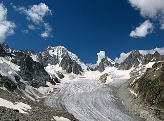
The Mer de Glace is a valley glacier located on the northern slopes of the Mont Blanc massif, in the French Alps. It is 7.5 km long and 200 metres (660 ft) deep but, when all its tributary glaciers are taken into account, it can be regarded as the longest and largest glacier in France, and the second longest in the Alps after the Aletsch Glacier.
I can no otherwise convey to you an image of this body of ice, broken into irregular ridges and deep chasms than by comparing it to waves instantaneously frozen in the midst of a violent storm.

The Klein Matterhorn is a peak of the Pennine Alps, overlooking Zermatt in the Swiss canton of Valais. At 3,883 metres (12,740 ft) above sea level, it is the highest place in Europe that can be reached by aerial tramway or gondola lift, as well as by any other means of transport. The Klein Matterhorn is part of the Breithorn massif and overlooks on its south side the almost equally high flat glacier named Breithorn Plateau, just north of the international border with Italy. The name "Klein Matterhorn" is a reference to its much larger neighbour, the Matterhorn, which lies 7 km (4.3 mi) away across the Theodul Pass.

Monte Rosa is a mountain massif in the eastern part of the Pennine Alps, on the border between Italy and Switzerland (Valais). The highest peak of the massif, amongst several peaks of over 4,000 m (13,000 ft), is the Dufourspitze, the second highest mountain in the Alps and western Europe, after Mont Blanc. The east face of the Monte Rosa towards Italy has a height of about 2,400 metres (7,900 ft) and is the highest mountain wall of the Alps.

The Swiss Plateau or Central Plateau is one of the three major landscapes in Switzerland, lying between the Jura Mountains and the Swiss Alps. It covers about 30% of the Swiss surface area, and is partly flat but mostly hilly. The average height is between 400 metres (1,300 ft) and 700 metres (2,300 ft) AMSL. It is by far the most densely populated region of Switzerland, the center of economy and important transportation.
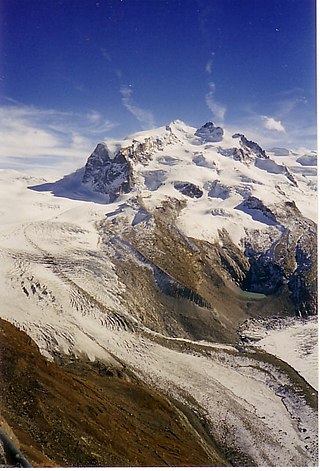
The Gorner Glacier is a valley glacier found on the west side of the Monte Rosa massif close to Zermatt in the canton of Valais, Switzerland. It is about 12.4 km (7.7 mi) long (2014) and 1 to 1.5 km wide. The entire glacial area of the glacier related to Gorner Glacier is 53 km2 (20 sq mi) (2007), which makes it the second largest glacial system in the Alps after the Aletsch Glacier system; however, in length it ranks third behind the Aletsch and Fiescher Glaciers. Numerous smaller glaciers connect with the Gorner Glacier. Its (former) tributaries are the Gorner Glacier, Monte Rosa Glacier, Grenzgletscher, Zwillingsgletscher, Schwärzegletscher, Breithorngletscher, Triftjigletscher, and Unterer Theodulgletscher.

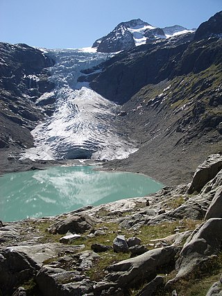
The Morteratsch Glacier is the largest glacier by area in the Bernina Range of the Bündner Alps in Switzerland.

The Plaine Morte Glacier is a glacier located at an elevation of 2,750 m (9,020 ft), in the canton of Bern above Lenk and in the Valais above Crans-Montana in Switzerland. The ice field, which covers 7.88 square kilometres (3.04 sq mi), is located below the mountain of Wildstrubel in the Bernese Alps. Its largest tongue is also called in German Rezligletscher or Rätzligletscher.

The Corbassière Glacier is a valley glacier in the Grand Combin massif in the Pennine Alps in southwestern Valais. It is 9.8 km (6.1 mi) long with an average width of slightly more than 1 km (0.62 mi) and covers an area of 17.4 km2 (6.7 sq mi).

The Oberaletsch Glacier is a valley glacier on the south side of the Bernese Alps, in the canton of Valais. It had a length of 9 km (5.6 mi) with an average width of just under 1 km (0.62 mi) and an area of about 22 km2 (8.5 sq mi) in 1973.
The Saleina Glacier is a 6 km (3.7 mi) long glacier (2002) situated on the north-eastern edge of the Mont Blanc Massif in the canton of Valais in Switzerland. It flows in a roughly north-easterly direction from the Aiguille d'Argentière, down towards the Val Ferret. The Saleina Hut sits above its right bank at an altitude of 2,691 meters above sea level.
The Trift Glacier is a 5 km (3 mi) long glacier (2005) in the Uri Alps near Gadmen, in the extreme east of the canton of Bern in Switzerland.
The Arolla Glacier is a 4 km (2.5 mi) long glacier (2005) situated in the Pennine Alps in the canton of Valais in Switzerland. In 1973 it had an area of 13.17 km2 (5.08 sq mi).
Eibsee is a lake in Bavaria, Germany, 9 km southwest of Garmisch-Partenkirchen and roughly 100 km southwest of Munich. It is 973.28 metres (3,193.2 ft) above sea-level and its surface area is 177.4 hectares. It is at the northerly base of the Zugspitze, Germany's highest mountain. The lake lies within the municipality of Grainau and is privately owned.

The Jungfrau-Aletsch protected area is located in south-western Switzerland between the cantons of Bern and Valais. It is a mountainous region in the easternmost side of the Bernese Alps, containing the northern wall of Jungfrau and Eiger, and the largest glaciated area in western Eurasia, comprising the Aletsch Glacier. The Jungfrau-Aletsch protected area is the first World Natural Heritage site in the Alps; it was inscribed in 2001.
Scenic Point is a 7,522-foot-elevation (2,293-meter) mountain summit located in the Two Medicine area of Glacier National Park, in Glacier County, Montana, United States. It is situated in the Lewis Range, six miles northwest of East Glacier Park Village, and approximately seven miles east of the Continental Divide, with precipitation runoff from the mountain draining into the Two Medicine River watershed. Topographic relief is significant as the north aspect rises over 2,600 feet above Lower Two Medicine Lake in one mile. Access to the summit is via the Continental Divide National Scenic Trail which traverses the upper slopes of this mountain. The trail to Scenic Point was constructed by the Great Northern Railway, and the summit once hosted a locomotive bell, a Swiss Alps tradition. The mountain's name was officially adopted in 1929 by the United States Board on Geographic Names.

The Vernagtferner is a glacier located in the Ötztal Alps in Tyrol, Austria, which covers an area of 7.31 km², making it one of the largest glaciers in the Eastern Alps. The glacier is situated on the southern side of the Weißkamm. The Hochvernagtspitze and the Brochkogel are the highest mountains within its catchment region. While some maps divide Vernagtferner into Kleiner Vernagtferner and Großer Vernagtferner, with the eastern portion of the Brochkogel area referred to as Kleiner Vernagtferner, these sub-areas do not meet scientific criteria for separate designation.


