
The Tödi, is a mountain massif and with the mountain peak Piz Russein the highest mountain in the Glarus Alps and the highest summit in the canton of Glarus, Switzerland. It is located on the border between the cantons of Graubünden, to the south, and Glarus, to the north, close to the point where those two cantons meet the canton of Uri, to the west. Although not the culminating point of Graubünden, it is its highest peak outside the Bernina range.

The Finsteraarhorn is a mountain lying on the border between the cantons of Bern and Valais. It is the highest mountain of the Bernese Alps and the most prominent peak of Switzerland. The Finsteraarhorn is the ninth-highest mountain and third-most prominent peak in the Alps. In 2001 the whole massif and surrounding glaciers were designated as part of the Jungfrau-Aletsch World Heritage Site.
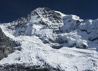
The Mönch at 4,110 metres (13,480 ft) is a mountain in the Bernese Alps, in Switzerland. Together with the Eiger and the Jungfrau, it forms a highly recognisable group of mountains, visible from far away.

The Kitzbühel Alps are a mountain range of the Central Eastern Alps surrounding the town of Kitzbühel in Tyrol, Austria. Geologically they are part of the western slate zone.

Grosses Fiescherhorn is a mountain peak of the Bernese Alps, located on the border between the cantons of Bern and ValaisValais, halfway between the Mönch and the Finsteraarhorn. At 4,049 metres (13,284 ft) above sea level, its summit culminates over the whole Fiescherhorn massif, which is also composed of the slightly lower Hinteres Fiescherhorn to the south and Kleines Fiescherhorn to the east. From the north both are well hidden behind other mountain peaks and can only been seen from Isch in Grindelwald. The mountain is shared between the municipalities of Grindelwald and Fieschertal.

Monte Rosa is a mountain massif in the eastern part of the Pennine Alps. It is between Italy's and Switzerland's (Valais). Monte Rosa is the second highest mountain in the Alps and western Europe, after Mont Blanc.

The Dom is a mountain of the Pennine Alps, located between Randa and Saas-Fee in the canton of Valais in Switzerland. With a height of 4,545 m (14,911 ft), it is the seventh highest summit in the Alps, overall. Based on prominence, it can be regarded as the third highest mountain in the Alps, and the second highest in Switzerland, after Monte Rosa. The Dom is the main summit of the Mischabel group, which is the highest massif lying entirely in Switzerland.

The Grand Combin is a mountain massif in the western Pennine Alps in the canton of Valais. At a height of 4,314 metres (14,154 ft) the summit of Combin de Grafeneire is one of the highest peaks in the Alps and the second most prominent of the Pennine Alps. The Grand Combin is also a large glaciated massif consisting of several summits, among which three are above 4000 metres. The highest part of the massif is wholly in Switzerland, although the border with Italy lies a few kilometres south.

Lyskamm, also known as Silberbast, is a mountain in the Pennine Alps lying on the border between Switzerland and Italy. It consists of a five-kilometre-long ridge with two distinct peaks. The mountain has gained a reputation for seriousness because of the many cornices lying on the ridge and the frequent avalanches, thus leading to its nickname the Menschenfresser.
Piz Kesch (German) or Piz d'Es-cha (Rumantsch) is a peak in the Albula Alps of the Rhaetian Alps in Switzerland. At 3,418 metres (11,214 ft), it is the highest peak in the Albula Alps and the municipality of Bergün, Grisons.

The Ober Gabelhorn is a mountain in the Pennine Alps in Switzerland, located between Zermatt and Zinal.

The Alphubel is a mountain of the Swiss Pennine Alps, located between the valleys of Zermatt and Saas in the canton of Valais. It is part of the Allalin Group, a subgroup of the Mischabel Group, which culminates at the Dom. The summit of the Alphubel consists of a large ice-covered plateau, part of the Fee Glacier on its east side. The west side of the mountain is more rocky and much steeper. It overlooks the Weingartensee.

The Dammastock is the highest mountain in the Urner Alps in Switzerland and is part of the Winterberg massif. Its summit ridge forms the border between the cantons of Uri and the Valais. It is the highest summit in the canton of Uri. The tripoint between the cantons of Berne, Valais and Uri lies near the Eggstock, north of the Dammastock. Politically, the Dammastcok is split between the municipalities of Göschenen (Uri) and Obergoms (Valais).

Mont Dolent is a mountain in the Mont Blanc massif and lies on the border between Italy, Switzerland and France.
The Dôme du Goûter is a mountain in the Mont Blanc massif. It is a shoulder of Mont Blanc, whose summit lies two kilometres to the south-east. The Dôme is traversed on ascents of Mont Blanc via the Bosses route.

The Weisshorn is a major peak of Switzerland and the Alps, culminating at 4,506 metres above sea level. It is part of the Pennine Alps and is located between the valleys of Anniviers and Zermatt in the canton of Valais. In the latter valley, the Weisshorn is one of the many 4000ers surrounding Zermatt, with Monte Rosa and the Matterhorn.

The Wildhorn is a mountain of the Alps, straddling the border between the Swiss cantons of Bern and Valais. At 3,248 metres (10,656 ft) above sea level, it is the highest summit of the Bernese Alps west of the Gemmi Pass. It forms a large glaciated massif, about 10 km wide, extending between the Sanetsch Pass and the Rawil Pass. Along with the Muverans, the Diablerets and the Wildstrubel, the Wildhorn is one of the four distinct mountain massifs of the Bernese Alps that lie west of the Gemmi Pass. The massif of the Wildhorn is at the centre between the valleys of the Saane, Simme and the Rhone (Valais). It comprises several distinct summits, including the Arpelistock, Le Sérac, the Geltenhorn, the Sex Noir, the Sex Rouge, the Schnidehorn and the Six des Eaux Froides. The main crest is between the glaciers named Tungelgletscher and Glacier du Wildhorn. South of the main summit is the almost equally high summit of Mont Pucel. The Wildhorn is surrounded by several large mountain lakes: the Lac de Sénin, the Lauenensee, the Iffigsee, the Lac de Tseuzier and the Lac des Audannes. The Tungelgletscher, on the north-east face, was measured as 1.9 km in length in 1973.

Piz Terri is a mountain in the Lepontine Alps, located on the border between the cantons of Ticino and Graubünden. At 3,149 metres above sea level it is the highest summit lying on the chain between Greina and Soreda Pass. Piz Terri overlooks Lake Luzzone in Val Blenio on its west side, Val Sumvitg on its north side and Lumnezia on its east side. Close localities are Olivone and Vrin (Lumnezia).
The Tieralplistock is a mountain of the Urner Alps, located on the border between the Swiss cantons of Bern and Valais. It lies between the Trift Glacier and the Rhone Glacier, just east of the lake of Gelmer.

The Fleckistock is a 3,417 metres high mountain in the Urner Alps, overlooking Wassen in the canton of Uri. It is the highest summit of the group lying east of the pass of Sustenjoch. This range, starting at the Stucklistock and ending at the Salbitschijen, separates the valleys of Voralp, above Göschenen and Meiental, above Wassen.

