
The Lepontine Alps are a mountain range in the north-western part of the Alps. They are located in Switzerland and Italy.

The Bernese Alps are a mountain range of the Alps, located in western Switzerland. Although the name suggests that they are located in the Berner Oberland region of the canton of Bern, portions of the Bernese Alps are in the adjacent cantons of Valais, Fribourg and Vaud, the latter being usually named Fribourg Alps and Vaud Alps respectively. The highest mountain in the range, the Finsteraarhorn, is also the highest point in the canton of Bern.

Valais, or Wallis, more formally the Canton of Valais, is one of the 26 cantons forming the Swiss Confederation. It is composed of thirteen districts and its capital and largest city is Sion. The flag of the canton is made of thirteen stars representing the districts, on a white-red background.

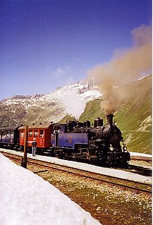
The Glacier Express (GEX) is a direct train connecting railway stations of the two major mountain resorts of Zermatt and St. Moritz via Andermatt in the central Swiss Alps. The train is not an "express" in the sense of being a high-speed train, but rather, in the sense that it provides a one-seat ride for an 8-hours-long end-to-end 291 km (181 mi) journey, and omits stops made by local trains. The Glacier Express is known as the slowest express train in the world. As St. Moritz and Zermatt are home to two well-known mountains, the Glacier Express is also said to travel from Matterhorn to Piz Bernina.

The Rhône Glacier is a glacier in the Swiss Alps and the source of the river Rhône and one of the primary contributors to Lake Geneva in the far eastern end of the Swiss canton of Valais. Because the glacier is located close to the Furka Pass road it is easily accessible.

Furka Pass, with an elevation of 2,429 metres (7,969 ft), is a high mountain pass in the Swiss Alps connecting Gletsch, Valais with Realp, Uri. The Furka Oberalp Bahn line through the Furka Tunnel bypasses the pass. The base tunnel opened in 1982 and replaced a tunnel at 2100 metres.

The Dammastock is the highest mountain in the Urner Alps in Switzerland and is part of the Winterberg massif. Its summit ridge forms the border between the cantons of Uri and the Valais. It is the highest summit in the canton of Uri. The tripoint between the cantons of Berne, Valais and Uri lies near the Eggstock, north of the Dammastock. Politically, the Dammastcok is split between the municipalities of Göschenen (Uri) and Obergoms (Valais).
The Uri Alps are a mountain range in Central Switzerland and part of the Western Alps. They extend into the cantons of Obwalden, Valais, Bern, Uri and Nidwalden and are bordered by the Bernese Alps and the Emmental Alps to the west, the Schwyzer Alps to the north, the Lepontine Alps to the south and the Glarus Alps to the east (Reuss).

The Witenwasserenstock is a peak between the Swiss cantons of Valais and Uri, located in the Lepontine Alps. Close to the summit lies the tripoint border between the cantons of Valais, Uri and Ticino and the triple watershed of the Rhine, Po and Rhône basins.

The Klein Furkahorn is a mountain of the Urner Alps, overlooking the Furka Pass on the border between the Swiss cantons of Valais and Uri. It lies near the southern end of the Galenstock-Gross Furkahorn chain, east of the Rhone Glacier.

The Gross Furkahorn is a mountain of the Urner Alps, located on the border between the Swiss cantons of Valais and Uri. It lies north of the Furka Pass and east of the Rhone Glacier.
The Winterstock is a mountain of the Urner Alps, located west of Realp in the canton of Uri. It lies on the range east of the Tiefenstock, that separates the Göschenertal from the valley called Urseren.
The Rhonestock is a mountain of the Uri Alps, located on the border between the Swiss cantons of Valais and Uri and belongs to the Winterberg massif. It lies south of the Dammastock, between the Rhone Glacier and the Damma Glacier.

The Schneestock is a mountain of the Urner Alps, located on the border between the Swiss cantons of Valais and Uri. It lies north of the Dammastock, between the Rhone Glacier and the Damma Glacier.
The Eggstock, is a minor prominence of the Uri Alps, forming the northern pillar of the Dammastock on the border between the cantons of Valais and Uri. The tripoint between the cantons of Bern, Valais and Uri is located 600 m west of the summit.

Realp railway station is a metre gauge station serving the municipality of Realp, in the Canton of Uri, Switzerland. The station is close to the eastern portal of the Furka Base Tunnel, on the Furka Oberalp Bahn (FO), which connects Brig in Valais, via Andermatt in Uri, with Göschenen, Uri, and Disentis/Mustér, Graubünden. Since 1 January 2003, the FO has been owned and operated by the Matterhorn Gotthard Bahn (MGB), following a merger between the FO and the Brig-Visp-Zermatt railway (BVZ).

Oberwald railway station is a railway station serving the village of Oberwald, in the Canton of Valais, Switzerland. The station is close to the western portal of the Furka Base Tunnel, on the metre gauge Furka Oberalp Bahn (FO), which connects Brig in Valais, via the base tunnel and Andermatt in Uri, with Göschenen, Uri, and Disentis/Mustér, Graubünden. Since 1 January 2003, the FO has been owned and operated by the Matterhorn Gotthard Bahn (MGB), following a merger between the FO and the Brig-Visp-Zermatt railway (BVZ).

Fiesch railway station is a metre gauge station serving the municipality of Fiesch, in the Canton of Valais, Switzerland. The station forms part of the Furka Oberalp Bahn (FO), which connects Brig in Valais, via Furka Base Tunnel, Andermatt in Uri, with Göschenen, Uri, and Disentis/Mustér, Graubünden. Since 1 January 2003, the FO has been owned and operated by the Matterhorn Gotthard Bahn (MGB), following a merger between the FO and the Brig-Visp-Zermatt railway (BVZ).
Muttbach-Belvédère railway station is a metre gauge railway passenger facility, at the western portal of the Furka Summit Tunnel, in the Canton of Valais, Switzerland.

The Muttenhorn is a mountain in the Lepontine Alps, located on the border between the cantons of Valais and Uri. At 3,099 metres above sea level, it overlooks the south side of Furka Pass. A glacier named Muttgletscher lies over its north-western flanks, above 2,600 metres.
