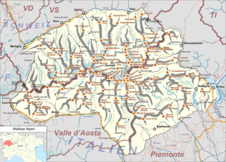
Pennine Alps

Last updated
Pennine Alps
French: Alpes Pennines, German: Walliser Alpen, Italian: Alpi Pennine, Latin: Alpes Poeninae
Valais Alps.jpg
View of Pennine Alps from Riederalp
Highest point
Peak Italian: Punta Dufour/German: Dufourspitze
Elevation 4,634 m (15,203 ft)
Coordinates 45°56′12″N7°52′00″E / 45.93667°N 7.86667°E / 45.93667; 7.86667
Geography
Walliser Alpen.png
Map of Pennine Alps and their location in Switzerland and Italy (red)
Countries Italy and Switzerland
Regions/Canton Aosta Valley, Piedmont and Valais
Range coordinates 46°05′N7°50′E / 46.083°N 7.833°E / 46.083; 7.833
Parent range Alps
Borders on Bernese Alps, Graian Alps, Lepontine Alps and Po Valley

The Pennine Alps French : Alpes Pennines, German : Walliser Alpen, Italian : Alpi Pennine, Latin : Alpes Poeninae ), sometimes referred to as the Valais Alps (which are just the Northern - Swiss - part of the Pennine Alps), are a mountain range in the western part of the Alps. They are located in Italy (the Aosta Valley and Piedmont) and Switzerland (Valais).

Contents

The Pennine Alps are amongst the three highest major subranges of the Alps, together with the Bernese Alps and the Graian Alps that include the Mont Blanc massif. [1]

Geography

The Italian side is drained by the rivers Dora Baltea, Sesia and Toce, tributaries of the Po. The Swiss side is drained by the Rhône.

The Great St Bernard Tunnel, under the Great St Bernard Pass, leads from Martigny, Switzerland to Aosta.

Morphology

The main chain (watershed between the Mediterranean Sea and the Adriatic Sea) runs from west to east on the border between Italy (south) and Switzerland (north). From Mont Vélan, the first high summit east of St Bernard Pass, the chain rarely goes below 3000 metres and contains many four-thousanders such as Matterhorn or Monte Rosa. The valleys are quite similar on both side of the border, being generally oriented perpendicular to the main chain and descending progressively into the Rhône Valley on the north and the Aosta Valley on the south. Unlike many other mountain ranges, the higher peaks are often located outside the main chain and found themselves between the northern valleys (Grand Combin, Weisshorn, Mischabel, Weissmies).

Peaks

The chief peaks of the Pennine Alps are:

NameHeight
Dufourspitze 4,634 m (15,203 ft)
Dunantspitze 4,632 m (15,197 ft)
Grenzgipfel 4,618 m (15,151 ft)
Nordend 4,609 m (15,121 ft)
Zumsteinspitze 4,563 m (14,970 ft)
Signalkuppe 4,554 m (14,941 ft)
Dom 4,545 m (14,911 ft)
Liskamm 4,538 m (14,888 ft)
Weisshorn 4,506 m (14,783 ft)
Täschhorn 4,491 m (14,734 ft)
Matterhorn 4,478 m (14,692 ft)
Parrotspitze 4,432 m (14,541 ft)
Dent Blanche 4,364 m (14,318 ft)
Nadelhorn 4,327 m (14,196 ft)
Grand Combin 4,314 m (14,154 ft)
Lenzspitze 4,294 m (14,088 ft)
Stecknadelhorn 4,241 m (13,914 ft)
Castor 4,230 m (13,878 ft)
Zinalrothorn 4,223 m (13,855 ft)
Hohberghorn 4,219 m (13,842 ft)
Alphubel 4,206 m (13,799 ft)
Rimpfischhorn 4,199 m (13,776 ft)
Strahlhorn 4,190 m (13,747 ft)
Dent d'Hérens 4,171 m (13,684 ft)
Breithorn 4,164 m (13,661 ft)
Bishorn 4,153 m (13,625 ft)
Breithornzwillinge 4,139 m (13,579 ft)
Pollux 4,092 m (13,425 ft)
Ober Gabelhorn 4,073 m (13,363 ft)
Dürrenhorn 4,035 m (13,238 ft)
Allalinhorn 4,027 m (13,212 ft)
Weissmies 4,031 m (13,225 ft)
Lagginhorn 4,010 m (13,156 ft)
Fletschhorn 3,993 m (13,100 ft)
Adlerhorn 3,988 m (13,084 ft)
Schalihorn 3,974 m (13,038 ft)
Jägerhorn 3,970 m (13,025 ft)
Grand Cornier 3,962 m (12,999 ft)
Ulrichshorn 3,925 m (12,877 ft)
Wellenkuppe 3,903 m (12,805 ft)
Feechopf 3,888 m (12,756 ft)
Klein Matterhorn 3,883 m (12,740 ft)
Pointe du Mountet 3,877 m (12,720 ft)
La Ruinette 3,879 m (12,726 ft)
NameHeight
Mont Blanc de Cheilon 3,870 m (12,697 ft)
Bouquetins 3,838 m (12,592 ft)
Brunegghorn 3,833 m (12,575 ft)
Tour de Boussine 3,833 m (12,575 ft)
Cima di Jazzi 3,818 m (12,526 ft)
Balfrin 3,802 m (12,474 ft)
Pigne d'Arolla 3,796 m (12,454 ft)
Mont Vélan 3,765 m (12,352 ft)
Kinhorn 3,750 m (12,303 ft)
Tête Blanche 3,750 m (12,303 ft)
L'Évêque 3,738 m (12,264 ft)
Le Pleureur 3,706 m (12,159 ft)
Aiguille de la Tsa 3,668 m (12,034 ft)
Besso 3,667 m (12,031 ft)
Mont Collon 3,637 m (11,932 ft)
Les Diablons 3,605 m (11,827 ft)
Pointes de Mourti 3,564 m (11,693 ft)
Le Ritord 3,556 m (11,667 ft)
Dents de Bertol 3,547 m (11,637 ft)
Mont Gelé 3,518 m (11,542 ft)
Petite Aiguille 3,517 m (11,539 ft)
Becca di Luseney 3,506 m (11,503 ft)
Château des Dames3,489 m (11,447 ft)
Tällihorn 3,448 m (11,312 ft)
Pigne de la Lé 3,396 m (11,142 ft)
Grand Tournalin3,379 m (11,086 ft)
Rosablanche 3,348 m (10,984 ft)
Wasuhorn 3,343 m (10,968 ft)
Mont Avril 3,341 m (10,961 ft)
Almagellhorn 3,327 m (10,915 ft)
Grande Rochère3,326 m (10,912 ft)
Corno Bianco 3,320 m (10,892 ft)
Testa Grigia 3,315 m (10,876 ft)
La Cassorte 3,301 m (10,830 ft)
Böshorn 3,268 m (10,722 ft)
Le Parrain 3,259 m (10,692 ft)
Sasseneire 3,259 m (10,692 ft)
Bösentrift 3,248 m (10,656 ft)
Festihorn 3,248 m (10,656 ft)
Grand Golliat 3,240 m (10,630 ft)
Jazzihorn 3,227 m (10,587 ft)
Pizzo Bianco3,216 m (10,551 ft)
Mont de la Gouille 3,212 m (10,538 ft)
Latelhorn 3,207 m (10,522 ft)
Jegihorn 3,206 m (10,518 ft)
NameHeight
Schwarzhorn 3,204 m (10,512 ft)
Lammenhorn 3,190 m (10,466 ft)
Gornergrat 3,136 m (10,289 ft)
Pointe d'Ar Pitetta 3,133 m (10,279 ft)
Frilihorn 3,124 m (10,249 ft)
Mont Rogneux 3,084 m (10,118 ft)
Le Boudri 3,070 m (10,072 ft)
Mont Néry 3,070 m (10,072 ft)
Seetalhorn 3,037 m (9,964 ft)
Bella Tola 3,028 m (9,934 ft)
Corno Bussola 3,023 m (9,918 ft)
Le Toûno 3,018 m (9,902 ft)
Sparruhorn 2,988 m (9,803 ft)
Monte Tagliaferro 2,964 m (9,724 ft)
Pointe de Barasson 2,963 m (9,721 ft)
Mont Blava 2,932 m (9,619 ft)
Riffelhorn 2,931 m (9,616 ft)
Palanche de la Cretta 2,927 m (9,603 ft)
Bec de la Montau 2,922 m (9,587 ft)
Ochsehorn 2,912 m (9,554 ft)
Signalhorn 2,911 m (9,551 ft)
Sex de Marinda 2,906 m (9,534 ft)
Aiguille des Angroniettes 2,885 m (9,465 ft)
Balmahorn 2,870 m (9,416 ft)
Roc d'Orzival 2,853 m (9,360 ft)
Le Mourin 2,766 m (9,075 ft)
Pletschuhorn 2,751 m (9,026 ft)
Becca de Corbassière 2,749 m (9,019 ft)
Cima del Rosso 2,624 m (8,609 ft)
Wenghorn 2,587 m (8,488 ft)
Cima di Bo 2,556 m (8,386 ft)
Ergischhorn 2,526 m (8,287 ft)
Glishorn 2,525 m (8,284 ft)
Crêta de Vella 2,519 m (8,264 ft)
Six Blanc 2,445 m (8,022 ft)
Cima Verosso 2,444 m (8,018 ft)
Guggilihorn 2,351 m (7,713 ft)
Testa di Comagna 2,106 m (6,909 ft)

Glaciers

Weissmies Weissmies.jpg
Weissmies
Grand Combin GrandCombin3.jpg
Grand Combin

Main glaciers:

Passes

Great St Bernard pass Great St Bernard-700px.jpg
Great St Bernard pass

The chief passes of the Pennine Alps are: [2]

Mountain passlocationtypeelevation
Sesiajoch Zermatt to Alagna snow4,42414,515
Domjoch Randa to Saas-Fee snow4,28614,062
LisjochZermatt to Gressoney-La-Trinité snow4,27714,033
MischabeljochZermatt to Saas-Feesnow3,85612,651
Alphubel PassZermatt to Saas-Feesnow3,80212,474
Adler PassZermatt to Saas-Feesnow3,79812,461
Moming PassZermatt to Zinal snow3,74512,287
SchwarztorZermatt to Ayas snow3,74112,274
Ried Pass Sankt-Niklaus to Saas-Feesnow3,59711,800
Neues WeisstorZermatt to Macugnaga snow3,58011,746
Allalin PassZermatt to Saas-Feesnow3,57011,713
Col de ValpellineZermatt to Aosta snow3,56211,687
BiesjochRanda to Turtmann snow3,54911,644
TriftjochZermatt to Zinalsnow3,54011,615
Col du Sonadon Bourg-Saint-Pierre to the Val de Bagnes snow3,48911,447
Col d'HerensZermatt to Evolène snow3,48011,418
Col DurandZermatt to Zinalsnow3,47411,398
Col des Maisons BlanchesBourg-Saint-Pierre to the Val de Bagnessnow3,42611,241
Col de Bertol Arolla to the Col d'Herenssnow3,41411,200
Col du Mont RougeVal de Bagnes to the Val d'Hérémence snow3,34110,962
Theodulpass Zermatt to Valtournenche snow3,32210,899
Col de TracuitZinal to Turtmannsnow3,25210,670
Zwischbergen PassSaas-Fee to Gondo snow3,24810,657
Col d'OrenVal de Bagnes to the Valpelline snow3,24210,637
Col de SeilonVal de Bagnes to the Val d'Hérémencesnow3,20010,499
Col du CretVal de Bagnes to the Val d'Hérémencesnow3,14810,329
Col de ValcourneraValtournenche to the Valpelline snow3,14710,325
Col de CollonArolla to Aostasnow3,13010,270
Col de ValsoreyBourg-Saint-Pierre to Aostasnow3,11310'214
Col de ChermontaneVal de Bagnes to Arollasnow308410,119
Cimes BlanchesValtournenche to Ayasbridle path2,9809,777
Col de TorrentEvolène to the Val de Torrentbridle path2,9249,593
Augstbord PassSankt-Niklaus to Turtmannbridle path2,8939,492
Col de Crête Sèche Val de Bagnes to the Valpellinesnow2,8889,475
Col d'OlenAlagna to Gressoneybridle path2,8719,420
Monte MoroSaas-Fee to Macugnaga bridle path2,8629,390
Pas de ChevresArolla to the Val d'Hérémencefootpath2,8519,354
Antrona PassSaas-Fee to Antrona bridle path2,8449,331
Col de SoreboisZinal to the Val de Torrentbridle path2,8259,269
Col de VessonaValpelline to Nus footpath2,7949,167
Fenêtre de DurandVal de Bagnes to Aosta bridle path2,7869,141
Z'Meiden PassZinal to Turtmannbridle path2,7729,095
Turlo PassAlagna to Macugnagafootpath2,7368,977
Fenêtre de Ferret Great St Bernard to the Swiss Val Ferretbridle path2,6998,855
Bettaforca Pass [3] (Bättforko)Ayas to Gressoney-La-Trinitébridle path2,6768,780
Col SerenaGreat St Bernard to Morgex footpath2,5388,327
Col Ferret Courmayeur to Orsièresbridle path2,5338,311
Col de ValdobbiaGressoney to the Val Sesia bridle path2,4798,134
Great St Bernard Martigny to Aosta road2,4728,111
Col de MoudAlagna to Rima bridle path2,3237,622
Col d'EguaRima to the Valle Anzasca bridle path2,2367,336
Simplon Pass Brig to Domodossola road2,0096,592
Bocchetta del Croso Piedicavallo to Valsesia bridle path1,9416,374
Baranca Pass Varallo to the Val Anzascabridle path1,8205,971

Nature conservation

Some regional nature parks, like the Parco Naturale Alta Valsesia (6,511 ha - Piedmont, IT), [4] the Riserva Naturale Mont Mars (390 ha - Aosta Valley, IT) [5] and the Regional park of Binn valley (15,891 ha - Valais, CH), [6] have been established on both sides of the main water divide.

See also

Maps

Related Research Articles

<span class="mw-page-title-main">Swiss Alps</span> Portion of the Alps that lies within Switzerland

The Alpine region of Switzerland, conventionally referred to as the Swiss Alps, represents a major natural feature of the country and is, along with the Swiss Plateau and the Swiss portion of the Jura Mountains, one of its three main physiographic regions. The Swiss Alps extend over both the Western Alps and the Eastern Alps, encompassing an area sometimes called Central Alps. While the northern ranges from the Bernese Alps to the Appenzell Alps are entirely in Switzerland, the southern ranges from the Mont Blanc massif to the Bernina massif are shared with other countries such as France, Italy, Austria and Liechtenstein.

<span class="mw-page-title-main">Bernese Alps</span> Part of the Alps mountain range in Switzerland

The Bernese Alps are a mountain range of the Alps, located in western Switzerland. Although the name suggests that they are located in the Berner Oberland region of the canton of Bern, portions of the Bernese Alps are in the adjacent cantons of Valais, Fribourg and Vaud, the latter being usually named Fribourg Alps and Vaud Alps respectively. The highest mountain in the range, the Finsteraarhorn, is also the highest point in the canton of Bern.

<span class="mw-page-title-main">Graian Alps</span> Mountain range in the western part of the Alps

The Graian Alps are a mountain range in the western part of the Alps.

<span class="mw-page-title-main">Main chain of the Alps</span> Central line of mountains that forms the divide of the Alps

The main chain of the Alps, also called the Alpine divide is the central line of mountains that forms the drainage divide of the range. Main chains of mountain ranges are traditionally designated in this way, and generally include the highest peaks of a range. The Alps are something of an unusual case in that several significant groups of mountains are separated from the main chain by sizable distances. Among these groups are the Dauphine Alps, the Eastern and Western Graians, the entire Bernese Alps, the Tödi, Albula and Silvretta groups, the Ortler and Adamello ranges, and the Dolomites of South Tyrol, as well as the lower Alps of Vorarlberg, Bavaria, and Salzburg.

This article lists the principal mountain passes and tunnels in the Alps, and gives a history of transport across the Alps.

<span class="mw-page-title-main">Valais</span> Canton of Switzerland

Valais ,,(German; Wallis) more formally the Canton of Valais/Canton of Wallis is one of the 26 cantons forming the Swiss Confederation. It is composed of thirteen districts and its capital and largest city is Sion. The flag of the canton is made of thirteen stars representing the districts, on a white-red background.

<span class="mw-page-title-main">Matterhorn</span> Mountain in the Swiss and Italian Alps

The Matterhorn is a mountain of the Alps, straddling the main watershed and border between Italy and Switzerland. It is a large, near-symmetric pyramidal peak in the extended Monte Rosa area of the Pennine Alps, whose summit is 4,478 metres (14,692 ft) above sea level, making it one of the highest summits in the Alps and Europe. The four steep faces, rising above the surrounding glaciers, face the four compass points and are split by the Hörnli, Furggen, Leone/Lion, and Zmutt ridges. The mountain overlooks the Swiss town of Zermatt, in the canton of Valais, to the northeast; and the Italian town of Breuil-Cervinia in the Aosta Valley to the south. Just east of the Matterhorn is Theodul Pass, the main passage between the two valleys on its north and south sides, which has been a trade route since the Roman Era.

<span class="mw-page-title-main">Gran Paradiso</span> Mountain in the Graian Alps in Italy

The Gran Paradiso or Grand Paradis is a mountain in the Graian Alps in Italy, located between the Aosta Valley and Piedmont regions. It is located in Gran Paradiso National Park.

<span class="mw-page-title-main">Breithorn</span> Mountain range of the Pennine Alps

The Breithorn is a mountain range of the Pennine Alps with its highest peak of the same name, located on the border between Switzerland and Italy. It lies on the main chain of the Alps, approximately halfway between the Matterhorn and Monte Rosa and east of the Theodul Pass. Most of the massif is glaciated and includes several subsidiary peaks, all located east of the main summit: the Central Breithorn, the western Breithorn Twin, the Gendarm and the Roccia Nera. The main summit is sometimes distinguished by the name Western Breithorn. The nearest settlements are Zermatt (Valais) and St-Jacques.

<span class="mw-page-title-main">Dufourspitze</span> Highest mountain in Switzerland

The Dufourspitze is the highest peak of Monte Rosa, an ice-covered mountain massif in the Alps. Dufourspitze is the highest mountain of both Switzerland and the Pennine Alps and is also the second-highest mountain of the Alps and Western Europe, after Mont Blanc. It is located between Switzerland and Italy. The peak itself is located wholly in Switzerland.

<span class="mw-page-title-main">Monte Rosa</span> Massif in Switzerland and Italy

Monte Rosa is a mountain massif in the eastern part of the Pennine Alps, on the border between Italy and Switzerland (Valais). The highest peak of the massif, amongst several peaks of over 4.000 m, is the Dufourspitze, the second highest mountain in the Alps and western Europe, after Mont Blanc. The east face of the Monte Rosa towards Italy has a height of about 2.400 meters and is the highest mountain wall of the Alps.

<span class="mw-page-title-main">Geography of the Alps</span> Description of the landforms of the Alps mountain range

The Alps form a large mountain range dominating Central Europe, including parts of Italy, France, Switzerland, Liechtenstein, Austria, Slovenia, Germany and Hungary.

<span class="mw-page-title-main">Tourism in Switzerland</span> Overview of tourism in Switzerland

Tourists are drawn to Switzerland's diverse landscape as well as the available activities, which take advantage of the Alpine climate and landscapes, in particular skiing and mountaineering.

<span class="mw-page-title-main">Castor (mountain)</span> Mountain in the Pennine Alps

Castor is a mountain in the Pennine Alps on the border between Valais, Switzerland and the Aosta Valley in Italy. It is the higher of a pair of twin peaks, the other being Pollux, named after the Gemini twins of Roman mythology. Castor's peak is at an elevation of 4,223 m (13,855 ft), and it lies between Breithorn and the Monte Rosa. It is separated from Pollux by a pass at 3,847 m (12,621 ft), named Passo di Verra in Italian and Zwillingsjoch in German.

<span class="mw-page-title-main">Cima di Jazzi</span> Mountain in Valais, Switzerland and Piedmont, Italy

The Cima di Jazzi is a mountain of the Pennine Alps, located on the Swiss-Italian border, just north of Monte Rosa. It overlooks Macugnaga on its east (Italian) side. The west (Swiss) side is entirely covered by glaciers.

The Petit Col Ferret is an Alpine pass between the canton of Valais and the Aosta Valley.

<span class="mw-page-title-main">Partizione delle Alpi</span>

The Partizione delle Alpi is a classification of the mountain ranges of the Alps, that is primarily used in Italian literature, but also in France and Switzerland. It was devised in 1926.

<span class="mw-page-title-main">Theodul Glacier</span> Glacier of the Alps

The Theodul Glacier is a glacier of the Alps, located south of Zermatt in the canton of Valais. It lies on the Swiss side of the Pennine Alps, although its upper basin touches the Italian region of the Aosta Valley. The glacier descends from the west side of the Breithorn and splits into two diverging branches above Gandegg: the Upper Theodul Glacier, spilling on a high plateau near Trockener Steg, together with the Furgg Glacier, and the Lower Theodul Glacier, reaching a height of about 2,500 metres (8,202 ft) above the Gorner Glacier.

<span class="mw-page-title-main">Mont-Fallère</span> Mountain in Italy

The Mont-Fallère or Mont Fallère is a 3,061.5 metres high mountain belonging to the Italian side of Pennine Alps.

<span class="mw-page-title-main">Mont Tout Blanc</span> Mountain in Italy

The Mont Tout Blanc is a 3,438.2 metres high mountain belonging to the Italian side of Graian Alps.

References

  1. Natural Wonders of the World. Dorling Kindersley Limited. 2017. p. 138. ISBN   9780241428436. The Alps contain many subranges, some of which are mapped below. The loftiest are the Pennine Alps, which contain 13 of the highest 20 alpine peaks; the Bernese Alps contain four; and the Mont Blanc Massif in the Graian Alps has three.
  2. Coolidge, William Augustus Brevoort (1911). "Alps"  . In Chisholm, Hugh (ed.). Encyclopædia Britannica . Vol. 1 (11th ed.). Cambridge University Press. p. 743.
  3. Hilary Sharp, Tour of Monte Rosa: A Trekker's Guide.
  4. Parco Naturale Alta Valsesia site on www.parks.it (accessed in April 2012)
  5. Parco del Mont Avic park site on www.parks.it (accessed in April 2012)
  6. Ein regionaler Naturpark, park site on www.landschaftspark-binntal.ch (accessed in April 2012)