
The Pennine Alps, sometimes referred to as the Valais Alps, are a mountain range in the western part of the Alps. They are located in Italy and Switzerland (Valais).

The Bernese Alps are a mountain range of the Alps, located in western Switzerland. Although the name suggests that they are located in the Berner Oberland region of the canton of Bern, portions of the Bernese Alps are in the adjacent cantons of Valais, Fribourg and Vaud, the latter being usually named Fribourg Alps and Vaud Alps respectively. The highest mountain in the range, the Finsteraarhorn, is also the highest point in the canton of Bern.

The main chain of the Alps, also called the Alpine divide is the central line of mountains that forms the drainage divide of the range. Main chains of mountain ranges are traditionally designated in this way, and generally include the highest peaks of a range. The Alps are something of an unusual case in that several significant groups of mountains are separated from the main chain by sizable distances. Among these groups are the Dauphine Alps, the Eastern and Western Graians, the entire Bernese Alps, the Tödi, Albula and Silvretta groups, the Ortler and Adamello ranges, and the Dolomites of Veneto and South Tyrol, as well as the lower Alps of Vorarlberg, Bavaria, and Salzburg.
Exploration of the higher region of the Alps by travellers from outside the immediate region only became popular from the 18th century. About 20 glacier passes were known before 1600, 25 more before 1700, and another 20 before 1800. While an attempt in 1689 to "re-open" the Col du Géant by Philibert-Amédée Arnod, an official from the duchy of Aosta, may be counted as having been made by a non-native, historical records do not show any further such activities until the last quarter of the 18th century. There are some records of very early ascents by non-natives, including that of the Rocciamelone in 1358 in fulfilment of a vow; that of the Mont Aiguille in 1492 by order of Charles VIII of France; and the ascent of the Gnepfstein, the lowest and the most westerly of the seven summits by Conrad Gessner in 1555.

The Matterhorn is a mountain of the Alps, straddling the main watershed and border between Italy and Switzerland. It is a large, near-symmetric pyramidal peak in the extended Monte Rosa area of the Pennine Alps, whose summit is 4,478 metres (14,692 ft) above sea level, making it one of the highest summits in the Alps and Europe. The four steep faces, rising above the surrounding glaciers, face the four compass points and are split by the Hörnli, Furggen, Leone/Lion, and Zmutt ridges. The mountain overlooks the Swiss town of Zermatt, in the canton of Valais, to the northeast; and the Italian town of Breuil-Cervinia in the Aosta Valley to the south. Just east of the Matterhorn is Theodul Pass, the main passage between the two valleys on its north and south sides, which has been a trade route since the Roman Era.
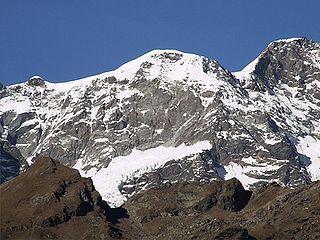
The Breithorn is a mountain range of the Pennine Alps with its highest peak of the same name, located on the border between Switzerland and Italy. It lies on the main chain of the Alps, approximately halfway between the Matterhorn and Monte Rosa and east of the Theodul Pass. Most of the massif is glaciated and includes several subsidiary peaks, all located east of the main summit: the Central Breithorn, the western Breithorn Twin, the Gendarm and the Roccia Nera. The main summit is sometimes distinguished by the name Western Breithorn. The nearest settlements are Zermatt (Valais) and St-Jacques.

The Dufourspitze is the highest peak of Monte Rosa, an ice-covered mountain massif in the Alps. Dufourspitze is the highest mountain of both Switzerland and the Pennine Alps and is also the second-highest mountain of the Alps and Western Europe, after Mont Blanc. It is located between Switzerland and Italy. The peak itself is located wholly in Switzerland.

Monte Rosa is a mountain massif in the eastern part of the Pennine Alps, on the border between Italy and Switzerland (Valais). The highest peak of the massif, amongst several peaks of over 4,000 m (13,000 ft), is the Dufourspitze, the second highest mountain in the Alps and western Europe, after Mont Blanc. The east face of the Monte Rosa towards Italy has a height of about 2,400 metres (7,900 ft) and is the highest mountain wall of the Alps.

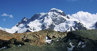
The Dom is a mountain of the Pennine Alps, located between Randa and Saas-Fee in the canton of Valais in Switzerland. With a height of 4,546 m (14,915 ft), it is the seventh highest summit in the Alps, overall. Based on prominence, it can be regarded as the third highest mountain in the Alps, and the second highest in Switzerland, after Monte Rosa. The Dom is the main summit of the Mischabel group, which is the highest massif lying entirely in Switzerland.
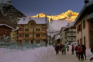
Alagna Valsesia is a comune and small village high in the Valsesia alpine valley in the province of Vercelli, Piedmont, northern Italy, a UNESCO World heritage site since 2013. It is a tourist place for mountaineering and winter sports, and it is internationally renowned for the freeride off-piste skiing. It is also the traditional starting point for the Margherita Hut climb, at 4,554 metres (14,941 ft) above sea level, the highest building in Europe. It was originally settled by Walser at the beginning of the 12th century. It is located at an elevation of 1,191 metres (3,907 ft) just south of the Monte Rosa, elevation 4,638 metres (15,217 ft) ; It is very close to Milan and to the international Milan–Malpensa Airport.

Lyskamm, also known as Silberbast, is a mountain in the Pennine Alps lying on the border between Switzerland and Italy. It consists of a five-kilometre-long ridge with two distinct peaks. The mountain has gained a reputation for seriousness because of the many cornices lying on the ridge and the frequent avalanches, thus leading to its nickname the Menschenfresser.

Castor is a mountain in the Pennine Alps on the border between Valais, Switzerland and the Aosta Valley in Italy. It is the higher of a pair of twin peaks, the other being Pollux, named after the Gemini twins of Roman mythology. Castor's peak is at an elevation of 4,225 m (13,862 ft), and it lies between Breithorn and the Monte Rosa. It is separated from Pollux by a pass at 3,847 m (12,621 ft), named Passo di Verra in Italian and Zwillingsjoch in German.

Pollux is a mountain in the Pennine Alps on the border between Valais, Switzerland and the Aosta Valley in Italy. It is the lower of a pair of twin peaks, the other being Castor, named after the Gemini twins of Roman mythology. Pollux' peak is at an elevation of 4,089 m (13,415 ft). It is separated from Castor by a pass at 3,846 m (12,618 ft), named Passo di Verra in Italian, Col de Verra in French and Zwillingsjoch in German.

The Dunantspitze, formerly called Ostspitze, is a peak of the Monte Rosa Massif in the Pennine Alps in Switzerland. It is the second highest peak of the massif, after the Dufourspitze (4,634 m) and the second highest summit in Switzerland, but its prominence is only about 15 metres. At the time of its first ascent it was unclear which of the summits was the higher.
The Parrotspitze is a peak in the Pennine Alps of Italy and Switzerland. It is located south of Dufourspitze in the Monte Rosa Massif. The mountain is named after Johann Jakob Friedrich Wilhelm Parrot, a German doctor, who made an attempt on the Piramide Vincent with Joseph Zumstein in 1816.

The Signalkuppe also known as Punta Gnifetti is a peak in the Pennine Alps on the border between Italy and Switzerland. It is a subpeak of Monte Rosa. The mountain is named after 'the Signal', a prominent gendarme atop the east ridge, named Cresta Signal.
The Grenzgipfel is a peak of Monte Rosa Massif, located on the border between Italy and Switzerland.
The Ludwigshöhe is a mountain in the Pennine Alps on the Swiss-Italian border. It is situated near the Dufourspitze in the Monte Rosa Massif. The summit is the tripoint between Valais, Aosta Valley and Piedmont.

The Vincent Pyramid is a mountain of the Pennine Alps, located on the border between the Italian regions of Aosta Valley and Piedmont. The Vincent Pyramid makes up a large buttress of the huge multi-summited Monte Rosa. It lies south of the Ludwigshöhe on the border with Switzerland, between the Lysgletscher and the Piode Glacier. A secondary summit of the Vincent Pyramid, the Punta Giordani/Giordanispétz, lies to the southeast. Both Vincent Pyramid and Punta Giordani are on the official UIAA list of Alpine four-thousanders.

Corno Bussola is a 3,023 metres high peak on the Italian side of the Pennine Alps.


