
Exploration of the higher region of the Alps by travellers from outside the immediate region only became popular from the 18th century. About 20 glacier passes were known before 1600, 25 more before 1700, and another 20 before 1800. While an attempt in 1689 to "re-open" the Col du Géant by Philibert-Amédée Arnod, an official from the duchy of Aosta, may be counted as having been made by a non-native, historical records do not show any further such activities until the last quarter of the 18th century. There are some records of very early ascents by non-natives, including that of the Rocciamelone in 1358 in fulfilment of a vow; that of the Mont Aiguille in 1492 by order of Charles VIII of France; and the ascent of the Gnepfstein, the lowest and the most westerly of the seven summits by Conrad Gessner in 1555.

Margherita of Savoy was Queen of Italy by marriage to her first cousin King Umberto I of Italy. She was the daughter of Prince Ferdinand of Savoy, Duke of Genoa and Princess Elisabeth of Saxony, and the mother of the King Victor Emmanuel III of Italy.

The Dent Blanche is a mountain in the Pennine Alps, lying in the canton of Valais in Switzerland. At 4,357 m (14,295 ft)-high, it is one of the highest peaks in the Alps.

The Dufourspitze is the highest peak of Monte Rosa, an ice-covered mountain massif in the Alps. Dufourspitze is the highest mountain of both Switzerland and the Pennine Alps and is also the second-highest mountain of the Alps and Western Europe, after Mont Blanc. It is located between Switzerland and Italy. The peak itself is located wholly in Switzerland.

Monte Rosa is a mountain massif in the eastern part of the Pennine Alps, on the border between Italy and Switzerland (Valais). The highest peak of the massif, amongst several peaks of over 4,000 m (13,000 ft), is the Dufourspitze, the second highest mountain in the Alps and western Europe, after Mont Blanc. The east face of the Monte Rosa towards Italy has a height of about 2,400 metres (7,900 ft) and is the highest mountain wall of the Alps.

The Dom is a mountain of the Pennine Alps, located between Randa and Saas-Fee in the canton of Valais in Switzerland. With a height of 4,546 m (14,915 ft), it is the seventh highest summit in the Alps, overall. Based on prominence, it can be regarded as the third highest mountain in the Alps, and the second highest in Switzerland, after Monte Rosa. The Dom is the main summit of the Mischabel group, which is the highest massif lying entirely in Switzerland.
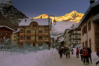
Alagna Valsesia is a comune and small village high in the Valsesia alpine valley in the province of Vercelli, Piedmont, northern Italy, a UNESCO World heritage site since 2013. It is a tourist place for mountaineering and winter sports, and it is internationally renowned for the freeride off-piste skiing. It is also the traditional starting point for the Margherita Hut climb, at 4,554 metres (14,941 ft) above sea level, the highest building in Europe. It was originally settled by Walser at the beginning of the 12th century. It is located at an elevation of 1,191 metres (3,907 ft) just south of the Monte Rosa, elevation 4,638 metres (15,217 ft) ; It is very close to Milan and to the international Milan–Malpensa Airport.
Christian Klucker was a Swiss mountain guide who made many first ascents in the Alps, particularly in the Bernina Range, the Bregaglia and the Pennine Alps.

Lyskamm, also known as Silberbast, is a mountain in the Pennine Alps lying on the border between Switzerland and Italy. It consists of a five-kilometre-long ridge with two distinct peaks. The mountain has gained a reputation for seriousness because of the many cornices lying on the ridge and the frequent avalanches, thus leading to its nickname the Menschenfresser.

The Ober Gabelhorn is a mountain in the Pennine Alps in Switzerland, located between Zermatt and Zinal.

Piz Badile is a mountain of the Bregaglia range in the Swiss canton of Graubünden and the Italian region of Lombardy. The border between the two countries runs along the summit ridge. Its north-east face, overlooking the Swiss Val Bregaglia near Soglio, is considered one of the six great north faces of the Alps. The name Badile means spade or shovel.

Castor is a mountain in the Pennine Alps on the border between Valais, Switzerland and the Aosta Valley in Italy. It is the higher of a pair of twin peaks, the other being Pollux, named after the Gemini twins of Roman mythology. Castor's peak is at an elevation of 4,225 m (13,862 ft), and it lies between Breithorn and the Monte Rosa. It is separated from Pollux by a pass at 3,847 m (12,621 ft), named Passo di Verra in Italian and Zwillingsjoch in German.
The Dent d'Hérens is a mountain in the Pennine Alps, lying on the border between Italy and Switzerland. The mountain lies a few kilometres west of the Matterhorn.

Pollux is a mountain in the Pennine Alps on the border between Valais, Switzerland and the Aosta Valley in Italy. It is the lower of a pair of twin peaks, the other being Castor, named after the Gemini twins of Roman mythology. Pollux' peak is at an elevation of 4,089 m (13,415 ft). It is separated from Castor by a pass at 3,846 m (12,618 ft), named Passo di Verra in Italian, Col de Verra in French and Zwillingsjoch in German.
The Parrotspitze is a peak in the Pennine Alps of Italy and Switzerland. It is located south of Dufourspitze in the Monte Rosa Massif. The mountain is named after Johann Jakob Friedrich Wilhelm Parrot, a German doctor, who made an attempt on the Piramide Vincent with Joseph Zumstein in 1816.

The Zumsteinspitze is a peak in the Pennine Alps on the border between Italy and Switzerland. It is a subpeak of Monte Rosa.

Besso is a mountain in the Pennine Alps in the Swiss canton of Valais. It has two significant summits: the main summit and the north-top.
The Gnifetti Hut is a refuge in the Alps in Aosta Valley, Italy. It is located at an altitude of 3,647 metres (11,965 ft), and provides access to mountaineers climbing any of the fifteen nearby 4,000 metre high summits of the Monte Rosa massif, and gives access to high-level glacier routes as well as to the Margherita Hut, located on the Signalkuppe.

The Vincent Pyramid is a mountain of the Pennine Alps, located on the border between the Italian regions of Aosta Valley and Piedmont. The Vincent Pyramid makes up a large buttress of the huge multi-summited Monte Rosa. It lies south of the Ludwigshöhe on the border with Switzerland, between the Lysgletscher and the Piode Glacier. A secondary summit of the Vincent Pyramid, the Punta Giordani/Giordanispétz, lies to the southeast. Both Vincent Pyramid and Punta Giordani are on the official UIAA list of Alpine four-thousanders.

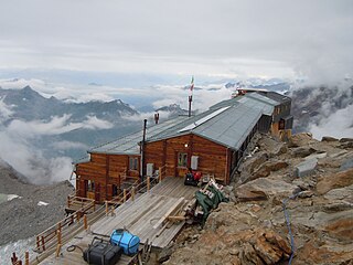
The Margherita Hut is a mountain hut belonging to the Italian Alpine Club, located on the summit of Punta Gnifetti of Monte Rosa, a mountain massif of the Alps lying near the border between Italy and Switzerland. At 4,554 metres (14,941 ft) above sea level, it is the highest building in Europe. It was originally opened in 1893 as a research station for high altitude medicine which it still is, but also serves as a simply equipped mountain hut for alpinists.

