
The Matterhorn is a mountain of the Alps, straddling the main watershed and border between Italy and Switzerland. It is a large, near-symmetric pyramidal peak in the extended Monte Rosa area of the Pennine Alps, whose summit is 4,478 metres (14,692 ft) above sea level, making it one of the highest summits in the Alps and Europe. The four steep faces, rising above the surrounding glaciers, face the four compass points and are split by the Hörnli, Furggen, Leone/Lion, and Zmutt ridges. The mountain overlooks the Swiss town of Zermatt, in the canton of Valais, to the northeast; and the Italian town of Breuil-Cervinia in the Aosta Valley to the south. Just east of the Matterhorn is Theodul Pass, the main passage between the two valleys on its north and south sides, which has been a trade route since the Roman Era.

The Eiger is a 3,967-metre (13,015 ft) mountain of the Bernese Alps, overlooking Grindelwald and Lauterbrunnen in the Bernese Oberland of Switzerland, just north of the main watershed and border with Valais. It is the easternmost peak of a ridge crest that extends across the Mönch to the Jungfrau at 4,158 m (13,642 ft), constituting one of the most emblematic sights of the Swiss Alps. While the northern side of the mountain rises more than 3,000 m (10,000 ft) above the two valleys of Grindelwald and Lauterbrunnen, the southern side faces the large glaciers of the Jungfrau-Aletsch area, the most glaciated region in the Alps. The most notable feature of the Eiger is its nearly 1,800-metre-high (5,900 ft) north face of rock and ice, named Eiger-Nordwand, Eigerwand or just Nordwand, which is the biggest north face in the Alps. This huge face towers over the resort of Kleine Scheidegg at its base, on the eponymous pass connecting the two valleys.

The Finsteraarhorn is a mountain lying on the border between the cantons of Bern and Valais. It is the highest mountain of the Bernese Alps and the most prominent peak of Switzerland. The Finsteraarhorn is the ninth-highest mountain and third-most prominent peak in the Alps. In 2001 the whole massif and surrounding glaciers were designated as part of the Jungfrau-Aletsch World Heritage Site.
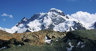
The Breithorn is a mountain range of the Pennine Alps with its highest peak of the same name, located on the border between Switzerland and Italy. It lies on the main chain of the Alps, approximately halfway between the Matterhorn and Monte Rosa and east of the Theodul Pass. Most of the massif is glaciated and includes several subsidiary peaks, all located east of the main summit: the Central Breithorn, the western Breithorn Twin, the Gendarm and the Roccia Nera. The main summit is sometimes distinguished by the name Western Breithorn. The nearest settlements are Zermatt (Valais) and St-Jacques.

The Jungfraujoch is a saddle connecting two major 4000ers of the Bernese Alps: the Jungfrau and the Mönch. It lies at an elevation of 3,463 metres (11,362 ft) above sea level and is directly overlooked by the rocky prominence of the Sphinx. The Jungfraujoch is a glacier saddle, on the upper snows of the Aletsch Glacier, and part of the Jungfrau-Aletsch area, situated on the boundary between the cantons of Bern and Valais, halfway between Interlaken and Fiesch.

The Grossglockner, or just Glockner, is, at 3,798 metres above the Adriatic (12,461 ft), the highest mountain in Austria and the highest mountain in the Alps east of the Brenner Pass. It is part of the larger Glockner Group of the Hohe Tauern range, situated along the main ridge of the Central Eastern Alps and the Alpine divide. The Pasterze, Austria's most extended glacier, lies on the Grossglockner's eastern slope.

The Dufourspitze is the highest peak of Monte Rosa, an ice-covered mountain massif in the Alps. Dufourspitze is the highest mountain of both Switzerland and the Pennine Alps and is also the second-highest mountain of the Alps and Western Europe, after Mont Blanc. It is located between Switzerland and Italy. The peak itself is located wholly in Switzerland.
The Grandes Jorasses is a mountain in the Mont Blanc massif, on the boundary between Haute-Savoie in France and Aosta Valley in Italy.

Piz Bernina is the highest mountain in the Eastern Alps, the highest point of the Bernina Range, and the highest peak in the Rhaetian Alps. It rises 4,048.6 m (13,283 ft) and is located south of Pontresina and near the major Alpine resort of St. Moritz, in the Engadin valley. It is also the most easterly mountain higher than 4,000 m (13,000 ft) in the Alps, the highest point of the Swiss canton of Graubünden, and the fifth-most prominent peak in the Alps. Although the summit lies within Switzerland, the massif is on the border with Italy. The "shoulder" known as La Spedla is the highest point in the Italian Lombardy region.

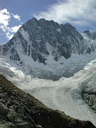
The Grünhorn is a mountain in the Bernese Alps range of the Swiss Alps. It is located on the ridge between the two largest glaciers of the Alps: the Aletsch Glacier to the west and the Fiescher Glacier to the east. To the south lies the Gross Wannenhorn and, to the north, the Gross Fiescherhorn.

Monte Rosa is a mountain massif in the eastern part of the Pennine Alps, on the border between Italy and Switzerland (Valais). The highest peak of the massif, amongst several peaks of over 4.000 m, is the Dufourspitze, the second highest mountain in the Alps and western Europe, after Mont Blanc. The east face of the Monte Rosa towards Italy has a height of about 2.400 meters and is the highest mountain wall of the Alps.

Ortler is, at 3,905 m (12,812 ft) above sea level, the highest mountain in the Eastern Alps outside the Bernina Range. It is the main peak of the Ortler Range. It is the highest point of the Southern Limestone Alps, of South Tyrol in Italy, of Tyrol overall, and, until 1919, of the Austrian-Hungarian empire. In German the mountain is commonly referred to as "König Ortler", like in the unofficial hymn of South Tyrol, the Bozner Bergsteigerlied.

The Dom is a mountain of the Pennine Alps, located between Randa and Saas-Fee in the canton of Valais in Switzerland. With a height of 4,545 m (14,911 ft), it is the seventh highest summit in the Alps, overall. Based on prominence, it can be regarded as the third highest mountain in the Alps, and the second highest in Switzerland, after Monte Rosa. The Dom is the main summit of the Mischabel group, which is the highest massif lying entirely in Switzerland.

The Grand Combin is a mountain massif in the western Pennine Alps in the canton of Valais. At a height of 4,314 metres (14,154 ft) the summit of Combin de Grafeneire is one of the highest peaks in the Alps and the second most prominent of the Pennine Alps. The Grand Combin is also a large glaciated massif consisting of several summits, among which three are above 4000 metres. The highest part of the massif is wholly in Switzerland, although the border with Italy lies a few kilometres south.
The Rheinwaldhorn is the highest point in the Swiss canton of Ticino at 3,402 metres above sea level. It lies on the border between the cantons of Graubünden and Ticino, in the Adula massif, part of the St. Gotthard massif of the Adula Alps in southern Switzerland.

Lyskamm, also known as Silberbast, is a mountain in the Pennine Alps lying on the border between Switzerland and Italy. It consists of a five-kilometre-long ridge with two distinct peaks. The mountain has gained a reputation for seriousness because of the many cornices lying on the ridge and the frequent avalanches, thus leading to its nickname the Menschenfresser.
The Dent d'Hérens is a mountain in the Pennine Alps, lying on the border between Italy and Switzerland. The mountain lies a few kilometres west of the Matterhorn.

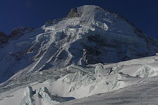
Pollux is a mountain in the Pennine Alps on the border between Valais, Switzerland and the Aosta Valley in Italy. It is the lower of a pair of twin peaks, the other being Castor, named after the Gemini twins of Roman mythology. Pollux' peak is at an elevation of 4,092 m (13,425 ft). It is separated from Castor by a pass at 3,847 m (12,621 ft), named Passo di Verra in Italian, Col de Verra in French and Zwillingsjoch in German.


