
The Alpine region of Switzerland, conventionally referred to as the Swiss Alps, represents a major natural feature of the country and is, along with the Swiss Plateau and the Swiss portion of the Jura Mountains, one of its three main physiographic regions. The Swiss Alps extend over both the Western Alps and the Eastern Alps, encompassing an area sometimes called Central Alps. While the northern ranges from the Bernese Alps to the Appenzell Alps are entirely in Switzerland, the southern ranges from the Mont Blanc massif to the Bernina massif are shared with other countries such as France, Italy, Austria and Liechtenstein.

The Pennine Alps, also known as the Valais Alps, are a mountain range in the western part of the Alps. They are located in Switzerland (Valais) and Italy.

Valais, or Wallis, more formally the Canton of Valais, is one of the 26 cantons forming the Swiss Confederation. It is composed of thirteen districts and its capital and largest city is Sion. The flag of the canton is made of thirteen stars representing the districts, on a white-red background.

The Matterhorn is a mountain of the Alps, straddling the main watershed and border between Switzerland and Italy. It is a large, near-symmetric pyramidal peak in the extended Monte Rosa area of the Pennine Alps, whose summit is 4,478 metres (14,692 ft) high, making it one of the highest summits in the Alps and Europe. The four steep faces, rising above the surrounding glaciers, face the four compass points and are split by the Hörnli, Furggen, Leone/Lion, and Zmutt ridges. The mountain overlooks the Swiss town of Zermatt, in the canton of Valais, to the north-east and the Italian town of Breuil-Cervinia in the Aosta Valley to the south. Just east of the Matterhorn is Theodul Pass, the main passage between the two valleys on its north and south sides, which has been a trade route since the Roman Era.

Zermatt is a municipality in the district of Visp in the German-speaking section of the canton of Valais in Switzerland. It has a year-round population of about 5,800 and is classified as a town by the Swiss Federal Statistical Office (FSO).

The Dufourspitze is the highest peak of Monte Rosa, an ice-covered mountain massif in the Alps. Dufourspitze is the highest mountain peak of both Switzerland and the Pennine Alps and is also the second-highest mountain of the Alps and Western Europe, after Mont Blanc. It is located between Switzerland and Italy.
The Matterhorn Gotthard Bahn is a narrow gauge railway line and a railway company in Switzerland. The track width is 1,000 mm. It was created in 2003 through an amalgamation of Furka Oberalp Bahn (FO) and BVZ Zermatt-Bahn (BVZ). The name comes from the Matterhorn and St. Gotthard Pass.

The Brig-Visp-Zermatt-Bahn (BVZ) – officially known between 1991 and 2002 as the BVZ Zermatt-Bahn – is a metre gauge railway in the Canton of Valais, Switzerland. Its 44 kilometre long line links the communities of Brig and Visp in the Rhone Valley with Täsch and the car free holiday resort of Zermatt in the Mattertal. The BVZ also forms part of the much travelled and admired route of the Glacier Express between St. Moritz and Zermatt. Opened in 1891 as the Visp-Zermatt-Bahn (VZ), the BVZ merged on 1 January 2003 with the Furka Oberalp Bahn (FO) to form the Matterhorn Gotthard Bahn (MGB).

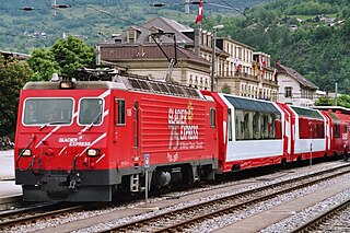
The Glacier Express (GEX) is a direct train connecting railway stations of the two major mountain resorts of Zermatt and St. Moritz via Andermatt in the central Swiss Alps. The train is not an "express" in the sense of being a high-speed train, but rather, in the sense that it provides a one-seat ride for an 8-hours-long end-to-end 291 km (181 mi) journey, and omits stops made by local trains. The Glacier Express is known as the slowest express train in the world. As St. Moritz and Zermatt are home to two well-known mountains, the Glacier Express is also said to travel from Matterhorn to Piz Bernina.

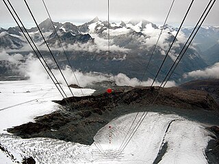
The Klein Matterhorn is a peak of the Pennine Alps, overlooking Zermatt in the Swiss canton of Valais. At 3,883 metres (12,740 ft) above sea level, it is the highest place in Europe that can be reached by aerial tramway or gondola lift, as well as by any other means of transport. The Klein Matterhorn is part of the Breithorn massif and overlooks on its south side the almost equally high flat glacier named Breithorn Plateau, just north of the international border with Italy. The name "Klein Matterhorn" is a reference to its much larger neighbour, the Matterhorn, which lies 7 km (4.3 mi) away across the Theodul Pass.

Monte Rosa is a mountain massif in the eastern part of the Pennine Alps. It is between Italy's and Switzerland's (Valais). Monte Rosa is the second highest mountain in the Alps and western Europe, after Mont Blanc.

The Dom is a mountain of the Pennine Alps, located between Randa and Saas-Fee in the canton of Valais in Switzerland. With a height of 4,545 m (14,911 ft), it is the seventh highest summit in the Alps, overall. Based on prominence, it can be regarded as the third highest mountain in the Alps, and the second highest in Switzerland, after Monte Rosa. The Dom is the main summit of the Mischabel group, which is the highest massif lying entirely in Switzerland.

The Gornergrat Railway is a mountain rack railway, located in the Swiss canton of Valais. It links the resort village of Zermatt, situated at 1,604 m (5,262 ft) above mean sea level, to the summit of the Gornergrat. The Gornergrat railway station is situated at an altitude of 3,089 m (10,135 ft), which makes the Gornergrat Railway the second highest railway in Europe after the Jungfrau, and the highest open-air railway of the continent. The line opened in 1898, and was the first electric rack railway to be built in Switzerland.

The Gornergrat is a rocky ridge of the Pennine Alps, overlooking the Gorner Glacier south-east of Zermatt in Switzerland. It can be reached from Zermatt by the Gornergrat rack railway (GGB), the highest open-air railway in Europe. Between the Gornergrat railway station and the summit is the Kulm Hotel. In the late 1960s two astronomical observatories were installed in the two towers of the Kulmhotel Gornergrat. The project “Stellarium Gornergrat” is hosted in the Gornergrat South Observatory.

The Weisshorn is a major peak of Switzerland and the Alps, culminating at 4,506 metres above sea level. It is part of the Pennine Alps and is located between the valleys of Anniviers and Zermatt in the canton of Valais. In the latter valley, the Weisshorn is one of the many 4000ers surrounding Zermatt, with Monte Rosa and the Matterhorn.

The Mettelhorn is a mountain of the Swiss Pennine Alps, located near Zermatt in the canton of Valais.

The Monte Rosa Hut is a mountain hut located near Zermatt on the Monte Rosa massif and above the Grenzgletscher sitting on a glacier-free rocky part called Untere Plattje at an altitude of 2,883 metres (9,459 ft). It is owned by the Swiss Alpine Club. The hut is the start of the normal route to the summit and other mountains in the area. The first hut was built in 1894–1895 just next to the then still much higher Border Glacier at an altitude of 2,795 metres (9,170 ft). A completely new building was inaugurated in 2009, a hi-tech, energy-wise almost self-sufficient, environmentally friendly mountain hut based on wood with an aluminium shell.

Zermatt railway station is a metre gauge railway station serving the car-free mountaineering and ski resort of Zermatt, in the Canton of Valais, Switzerland. It is the southern terminus of the BVZ Zermatt-Bahn (BVZ), which connects Zermatt with standard gauge lines at Visp and Brig. Since 1 January 2003, the BVZ has been owned and operated by the Matterhorn Gotthard Bahn (MGB), following a merger between the BVZ and the Furka Oberalp Bahn (FO). The station is across the street from Zermatt GGB railway station, the valley terminus of the Gornergrat Railway.
The Theodul Glacier is a glacier of the Alps, located south of Zermatt in the canton of Valais. It lies on the Swiss side of the Pennine Alps, although its upper basin touches the Italian region of the Aosta Valley. The glacier descends from the west side of the Breithorn and splits into two diverging branches above Gandegg: the Upper Theodul Glacier, spilling on a high plateau near Trockener Steg, together with the Furgg Glacier, and the Lower Theodul Glacier, reaching a height of about 2,500 metres (8,202 ft) above the Gorner Glacier. Both branches are part of the Rhone basin, through the rivers Gornera, Mattervispa, and Vispa. Slightly above the glacier splitting is the Theodul Pass, crossing the border between Switzerland and Italy, and connecting Zermatt to Breuil-Cervinia. On the west, the Theodul Glacier is overlooked by the Matterhorn.
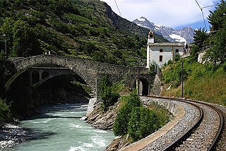
The Vispa is a river in the canton of Valais, located in the Visp area. It is essentially composed of two large branches: the Matter Vispa and the Saaser Vispa, converging at Stalden, then forming the Vispa proper, flowing for less than 10 kilometres before converging with the Rhône at Visp. The Vispa is a left and major affluent of the Rhône, before it enters Lake Geneva.


