
The Matter Valley is located in southwestern Switzerland, south of the Rhone valley in the canton of Valais. The village of Zermatt is the most important settlement of the valley, which is surrounded by many four-thousanders, including the Matterhorn.

Arolla is a village in the municipality of Evolène in the canton of Valais in Switzerland.

The Gornergrat Railway is a mountain rack railway, located in the Swiss canton of Valais. It links the resort village of Zermatt, situated at 1,604 m (5,262 ft) above mean sea level, to the summit of the Gornergrat. The Gornergrat railway station is situated at an altitude of 3,089 m (10,135 ft), which makes the Gornergrat Railway the second highest railway in Europe after the Jungfrau, and the highest open-air railway of the continent. The line opened in 1898, and was the first electric rack railway to be built in Switzerland.
Winkelmatten is a suburb of Zermatt, Switzerland. It was once a separate small hamlet, but as Zermatt has grown it has become incorporated within the greater conurbation.
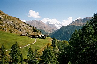
Zmutt is a small village in the municipality of Zermatt, Valais, Switzerland, situated at 1936 m in the Zmutt Valley (Zmuttal) west of Zermatt. The village chapel is dedicated to Saint Catherine of Alexandria, patroness of the Valais. The valley passes the northern slope of the Matterhorn and terminates in the Zmutt Glacier on the border to Italy's Aosta Valley.

Muğanlı is a village in the Qubadli Rayon of Azerbaijan.

The Hörnli Hut is a mountain hut located at the foot of the north-eastern ridge of the Matterhorn. It is situated at 3,260 metres (10,700 ft) above sea level, a few kilometres south-west of the town of Zermatt in the canton of Valais in Switzerland. It is also known as Berghaus Matterhorn.
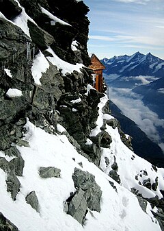
The Solvay Hut or Solvay Bivouac is a mountain hut located on the north-eastern ridge of the Matterhorn, near Zermatt in the canton of Valais. At 4,003 metres (13,133 ft) it is the highest mountain hut owned by the Swiss Alpine Club, but can be used only in case of emergency. The Hörnli Hut lying on the same ridge is the starting point of the normal route to the summit.

The Vignettes Hut is an alpine hut, located south of Arolla in the Swiss canton of Valais. It lies at a height of 3,160 metres above sea level, at the foot of the Pigne d'Arolla and near the Col de Chermotane in the Pennine Alps. All accesses to the hut involve glacier crossing.
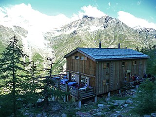
The Europa Hut is a mountain hut located in the Mattertal above Randa in the Mischabel range at 2,265 m, owned by the Swiss Alpine Club. It lies on the Grächen-Zermatt high trail, called Europaweg. From the hut a trail leads to the Dom Hut, on the normal route to the Dom.

The Schönbiel Hut is a mountain hut located north of the Matterhorn. It is situated at 2,694 metres (8,839 ft) above sea level, north of the Zmutt Glacier, a few kilometers west of the town of Zermatt in the canton of Valais in Switzerland. The actual hut was built by the Swiss Alpine Club in 1955, after the demolition of an older hut, built in 1909.

Riffelalp is a hamlet in the municipality of Zermatt in the canton of Valais. It is located at a height of 2,222 metres (7,290 ft) above sea level, just above the tree line, approximately halfway between the town of Zermatt and the Gornergrat mountain. Once the site of the prestigious Riffelalp Grand Hotel, today Riffelalp mainly consists of a large hotel complex, the Riffelalp Resort 2222m, and a chapel.
Xinhua District is a core district of the city of Pingdingshan, Henan province, China.

The Monte Rosa is a hotel, located in the main street of Zermatt. It was frequented by the members of the Alpine Club, including Edward Whymper who made the first ascent of the Matterhorn in 1865. The hotel is named after the highest mountain near Zermatt, Monte Rosa.
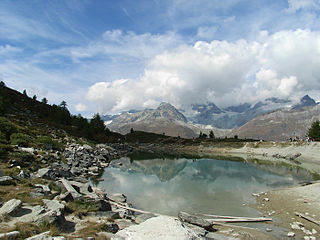
The Grünsee is a small lake near Zermatt, Switzerland, which is fed by the Findel Glacier. It is quite remote and is only accessible by foot, a small hub of the many footpaths in the area. There is a small hamlet nearby of the same name.

The Riffelalp tram is a high altitude tramway line located in the Swiss canton of Valais near the resort of Zermatt. The line links the Riffelalp Resort to Riffelalp station, on the Gornergrat railway, and via that line to Zermatt and beyond.

Findeln is a group of hamlets above Zermatt in the canton of Valais. They are located on the south facing slopes of the Sunnegga–Unterrothorn–Oberrothorn mountains. The main hamlets are Eggen and Ze Gassen, where there is a chapel. Both are easily accessible by the Zermatt–Sunnegga funicular.

The Dent Blanche Hut is a mountain hut of the Swiss Alpine Club, located south of Les Haudères in the canton of Valais. The hut lies at a height of 3,507 metres above sea level, at the foot of the Dent Blanche in the Pennine Alps. The hut, located at the upper end of the valley of Hérens near the watershed with the valley of Zermatt, overlooks the Ferpècle Glacier.

The Rothorn Hut is an alpine hut, located above Zermatt in the canton of Valais. It is located at a height of 3,198 metres above sea level, at the foot of the Zinalrothorn. It can be accessed via the Trift valley by a trail from Zermatt.


