
Landslides, also known as landslips, or rockslides, are several forms of mass wasting that may include a wide range of ground movements, such as rockfalls, mudflows, shallow or deep-seated slope failures and debris flows. Landslides occur in a variety of environments, characterized by either steep or gentle slope gradients, from mountain ranges to coastal cliffs or even underwater, in which case they are called submarine landslides.

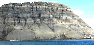
Scree is a collection of broken rock fragments at the base of a cliff or other steep rocky mass that has accumulated through periodic rockfall. Landforms associated with these materials are often called talus deposits. Talus deposits typically have a concave upwards form, where the maximum inclination corresponds to the angle of repose of the mean debris particle size. The exact definition of scree in the primary literature is somewhat relaxed, and it often overlaps with both talus and colluvium.
Mass wasting, also known as mass movement, is a general term for the movement of rock or soil down slopes under the force of gravity. It differs from other processes of erosion in that the debris transported by mass wasting is not entrained in a moving medium, such as water, wind, or ice. Types of mass wasting include creep, solifluction, rockfalls, debris flows, and landslides, each with its own characteristic features, and taking place over timescales from seconds to hundreds of years. Mass wasting occurs on both terrestrial and submarine slopes, and has been observed on Earth, Mars, Venus, Jupiter's moon Io, and on many other bodies in the Solar System.

Socompa is a large stratovolcano at the border of Argentina and Chile with an elevation of 6,051 metres (19,852 ft) metres. Part of the Chilean and Argentine Andean Volcanic Belt (AVB), it is within the Central Volcanic Zone, one of the various segments of the AVB. This part of the Andean volcanic belt begins in Peru and runs first through Bolivia and Chile, and then through Argentina and Chile, and contains about 44 active volcanoes. Socompa lies close to the pass of the same name, where the Salta-Antofagasta railway crosses the border.

A rockfall or rock-fall is a quantity/sheets of rock that has fallen freely from a cliff face. The term is also used for collapse of rock from roof or walls of mine or quarry workings. "A rockfall is a fragment of rock detached by sliding, toppling, or falling, that falls along a vertical or sub-vertical cliff, proceeds down slope by bouncing and flying along ballistic trajectories or by rolling on talus or debris slopes."
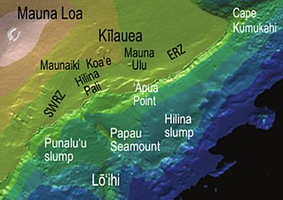
The Hilina Slump, on the south flank of the Kīlauea Volcano on the southeast coast of the Big Island of Hawaiʻi, is the most notable of several landslides that ring each of the Hawaiian Islands. These landslides are the means by which material deposited at a volcano's vents are transferred downward and seaward, eventually spilling onto the seabed to broaden the island.

A mudflow, also known as mudslide or mud flow, is a form of mass wasting involving fast-moving flow of debris and dirt that has become liquified by the addition of water. Such flows can move at speeds ranging from 3 meters/minute to 5 meters/second. Mudflows contain a significant proportion of clay, which makes them more fluid than debris flows, allowing them to travel farther and across lower slope angles. Both types of flow are generally mixtures of particles with a wide range of sizes, which typically become sorted by size upon deposition.

Rock glaciers are distinctive geomorphological landforms, consisting either of angular rock debris frozen in interstitial ice, former "true" glaciers overlain by a layer of talus, or something in-between. Rock glaciers are normally found at high latitudes and/or elevations, and may extend outward and downslope from talus cones, glaciers or terminal moraines of glaciers.

A Sturzstrom or rock avalanche is a large landslide consisting of soil and rock which travels a great horizontal distance compared to its initial vertical drop. Sturzstroms have similarities to the flow of glaciers, mudflows, and lava flows. They flow across land fairly easily, and their mobility increases when volume increases. They have been found on other bodies in the Solar System, including the Moon, Mars, Venus, Io, Callisto, Iapetus, and Phobos.

On February 17, 2006, a massive rock slide-debris avalanche occurred in the Philippine province of Southern Leyte, causing widespread damage and loss of life. The deadly landslide followed a 10-day period of heavy rain and a minor earthquake. The official death toll was 1,126.
There have been known various classifications of landslides. Broad definitions include forms of mass movement that narrower definitions exclude. For example, the McGraw-Hill Encyclopedia of Science and Technology distinguishes the following types of landslides:
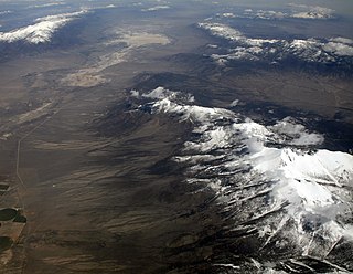
Basin and range topography is characterized by alternating parallel mountain ranges and valleys. It is a result of crustal extension due to mantle upwelling, gravitational collapse, crustal thickening, or relaxation of confining stresses. The extension results in the thinning and deformation of the upper crust, causing it to fracture and create a series of long parallel normal faults. This results in block faulting, where the blocks of rock between the normal faults either subside, uplift, or tilt. The movement of these blocks results in the alternating valleys and mountains. As the crust thins, it also allows heat from the mantle to more easily melt rock and form magma, resulting in increased volcanic activity.

The Khait or Hoit landslide occurred on July 10, 1949 in the Hoit district in the Gharm Oblast in the Tajik Soviet Socialist Republic, then part of the Soviet Union. 'Khait' is a transliteration from Russian: Хаит; the local modern spelling is Hoit.

Lobate debris aprons (LDAs) are geological features on Mars, first seen by the Viking Orbiters, consisting of piles of rock debris below cliffs. These features have a convex topography and a gentle slope from cliffs or escarpments, which suggest flow away from the steep source cliff. In addition, lobate debris aprons can show surface lineations as do rock glaciers on the Earth.
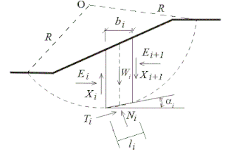
Slope stability analysis is a static or dynamic, analytical or empirical method to evaluate the stability of slopes of soil- and rock-fill dams, embankments, excavated slopes, and natural slopes in soil and rock. It is performed to assess the safe design of a human-made or natural slopes and the equilibrium conditions. Slope stability is the resistance of inclined surface to failure by sliding or collapsing. The main objectives of slope stability analysis are finding endangered areas, investigation of potential failure mechanisms, determination of the slope sensitivity to different triggering mechanisms, designing of optimal slopes with regard to safety, reliability and economics, and designing possible remedial measures, e.g. barriers and stabilization.

The Flims rockslide happened about 10,000 years ago in eastern Switzerland. It is the largest known landslide in the Alps, and the biggest worldwide whose effects are still visible, moving some 12 km3 (2.9 cu mi) of rock, about 300 times that of the historic Swiss Goldau landslide. The town of Flims can be found at the line where the slip surface disappears under the debris. North of Flims the rock face of Flimserstein stands 350 metres (1,148 ft) high whereas more westerly the slide surface is clearly visible. South of Flims is a huge hilly debris area that has been forest ever since, as this area is not suitable for farming, firstly for its shape and, even more for its lack of water. The river Rhine crosses this debris in a gorge called Ruinaulta. The Rhine still runs in debris, which shows that it has not yet reached the level it had before the incident. The highest hill in the debris area is almost 200 metres (656 ft) higher than Flims at the end of the sliding surface.
Mountains are widely distributed across the surface of Io, the innermost large moon of Jupiter. There are about 115 named mountains; the average length is 157 km (98 mi) and the average height is 6,300 m (20,700 ft). The longest is 570 km (350 mi), and the highest is Boösaule Montes, at 17,500 metres (57,400 ft), taller than any mountain on Earth. Ionian mountains often appear as large, isolated structures; no global tectonic pattern is evident, unlike on Earth, where plate tectonics is dominant.

The 2010 Mount Meager landslide was a large catastrophic debris avalanche that occurred in southwestern British Columbia, Canada, on August 6 at 3:27 a.m. PDT (UTC-7). More than 45,000,000 m3 (1.6×10⁹ cu ft) of debris slid down Mount Meager, temporarily blocking Meager Creek and destroying local bridges, roads and equipment. It was one of the largest landslides in Canadian history and one of over 20 landslides to have occurred from the Mount Meager massif in the last 10,000 years.
The Engadine Line is an over 50 kilometres (30 mi) long strike-slip fault in the Swiss canton of Graubünden, which extends into Italy and Austria. It runs along the Engadine Valley and the Bregaglia Valley and offsets Austroalpine and Penninic units in a sinistral direction. The western end of the fault appears to peter out into ductile deformation in the Bregaglia Valley or continues as the Gruf Line to the southwest; the eastern end is buried by the Ötztal tectonic block and may continue as the "Inntal fault", "Isar fault" or "Loisach fault".

The area of Oeschinen Lake and Kander river valley in Switzerland have been subject of multiple large landslides during the Holocene. Both the number and timing of landslides is controversial, with the most recent estimates stating that the large Kander landslide occurred about 3,210 years ago and the smaller Oeschinen Lake landslide 2,300 years ago. Both may have been caused by earthquakes, and the latter landslide generated the Oeschinen Lake. More recent landslides have occurred, and unstable rock masses occur in the landslide area.


