The Niagara Escarpment is a long escarpment, or cuesta, in Canada and the United States that starts from the south shore of Lake Ontario westward, circumscribes the top of the Great Lakes Basin running from New York through Ontario, Michigan, and Wisconsin. The escarpment is the cliff over which the Niagara River plunges at Niagara Falls, for which it is named.

An escarpment is a steep slope or long cliff that forms as a result of faulting or erosion and separates two relatively level areas having different elevations.

An inselberg or monadnock is an isolated rock hill, knob, ridge, or small mountain that rises abruptly from a gently sloping or virtually level surrounding plain. In Southern Africa a similar formation of granite is known as a koppie, an Afrikaans word from the Dutch diminutive word kopje. If the inselberg is dome-shaped and formed from granite or gneiss, it can also be called a bornhardt, though not all bornhardts are inselbergs. An inselberg results when a body of rock resistant to erosion, such as granite, occurring within a body of softer rocks, is exposed by differential erosion and lowering of the surrounding landscape.
Landforms are categorized by characteristic physical attributes such as their creating process, shape, elevation, slope, orientation, rock exposure, and soil type.
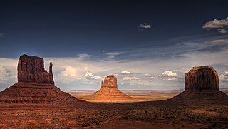
In geomorphology, a butte is an isolated hill with steep, often vertical sides and a small, relatively flat top; buttes are smaller landforms than mesas, plateaus, and tablelands. The word butte comes from the French word butte, meaning knoll ; its use is prevalent in the Western United States, including the southwest where mesa is used for the larger landform. Due to their distinctive shapes, buttes are frequently landmarks in plains and mountainous areas. To differentiate the two landforms, geographers use the rule of thumb that a mesa has a top that is wider than its height, while a butte has a top that is narrower than its height.

A mesa is an isolated, flat-topped elevation, ridge or hill, which is bounded from all sides by steep escarpments and stands distinctly above a surrounding plain. Mesas characteristically consist of flat-lying soft sedimentary rocks capped by a more resistant layer or layers of harder rock, e.g. shales overlain by sandstones. The resistant layer acts as a caprock that forms the flat summit of a mesa. The caprock can consist of either sedimentary rocks such as sandstone and limestone; dissected lava flows; or a deeply eroded duricrust. Unlike plateau, whose usage does not imply horizontal layers of bedrock, e.g. Tibetan Plateau, the term mesa applies exclusively to the landforms built of flat-lying strata. Instead, flat-topped plateaus are specifically known as tablelands.

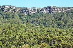
The Great Western Tiers are a collection of mountain bluffs that form the northern edge of the Central Highlands plateau in Tasmania, Australia. The bluffs are contained within the Tasmanian Wilderness World Heritage Site.

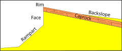
A cuesta is a hill or ridge with a gentle slope on one side, and a steep slope on the other. In geology the term is more specifically applied to a ridge where a harder sedimentary rock overlies a softer layer, the whole being tilted somewhat from the horizontal. This results in a long and gentle backslope called a dip slope that conforms with the dip of resistant strata, called caprock. Where erosion has exposed the frontslope of this, a steep slope or escarpment occurs. The resulting terrain may be called scarpland.

A dip slope is a topographic (geomorphic) surface which slopes in the same direction, and often by the same amount, as the true dip or apparent dip of the underlying strata. A dip slope consists of the upper surface of a resistant layer of rock, often called caprock, that is commonly only slightly lowered and reduced in steepness by erosion. Dip slopes form the backslopes of cuestas, homoclinal ridges, hogbacks, and flatirons. The frontslopes of such ridges consist of either an escarpment, a steep slope, or perhaps even a line of cliffs. Generally, cuestas and homoclinal ridges are asymmetrical in that their dip slopes are less steep than their escarpments. In the case of hogbacks and flatirons, the dip of the rocks is so steep that their dip slope approaches the escarpment in their steepness.

A fault scarp is a small step or offset on the ground surface where one side of a fault has moved vertically with respect to the other. It is the topographic expression of faulting attributed to the displacement of the land surface by movement along faults. They are exhibited either by differential movement and subsequent erosion along an old inactive geologic fault, or by a movement on a recent active fault.

The Great Escarpment is a major topographical feature in Africa that consists of steep slopes from the high central Southern African plateau downward in the direction of the oceans that surround southern Africa on three sides. While it lies predominantly within the borders of South Africa, in the east the escarpment extends northward to form the border between Mozambique and Zimbabwe, continuing on beyond the Zambezi river valley to form the Muchinga Escarpment in eastern Zambia. In the west, it extends northward into Namibia and Angola. It is the combination of this escarpment and the aridity of Southern Africa that leads to the lack of navigable rivers in South Africa.
Caprock or cap rock is a more resistant rock type overlying a less resistant rock type, analogous to an upper crust on a cake that is harder than the underlying layer.

A homoclinal ridge or strike ridge is a hill or ridge with a moderate, generally between 10° and 30°, sloping backslope. Its backslope is a dip slope, that conforms with the dip of a resistant stratum or strata, called caprock. On the other side of the other slope, which is its frontslope, of a homoclinal ridge is a steeper or even cliff-like frontslope (escarpment) that is formed by the outcrop of the caprock. The escarpment cuts through the dipping strata that comprises the homoclinal ridge.

Traditionally in geomorphology, a flatiron is a steeply sloping triangular landform created by the differential erosion of a steeply dipping, erosion-resistant layer of rock overlying softer strata. Flatirons have wide bases that form the base of a steep, triangular facet that narrows upward into a point at its summit. The dissection of a hogback by regularly spaced streams often results in the formation of a series of flatirons along the strike of the rock layer that formed the hogback. As noted in some, but not all definitions, a number of flatirons are perched upon the slope of a larger mountain with the rock layer forming the flatiron inclined in the same direction as, but often at a steeper angle than the associated mountain slope. The name flatiron refers to their resemblance to an upended, household flatiron.

Nilokeras Scopulus is a long escarpment (cliff) in the northern hemisphere of the planet Mars. It is located along the southeastern boundary of the Tempe Terra plateau and forms the northern valley wall of the downstream portion of the immense Kasei Valles outflow channel system. The escarpment is 765 km long and ranges from 1 to a little over 2 km (3300–6600 ft) in height.
The Great Escarpment in eastern Australia is an escarpment that runs east of the Great Dividing Range along most of the east of the continent. It was created due to formation of a new continental margin in the Mesozoic, followed by tectonic uplifting of the divide and then scarp retreat. The escarpment is estimated to be approximately 3,600 kilometres (2,200 mi) in length, from north to south.

The Shinarump Conglomerate is a geologic formation found in the Four Corners region of the United States. It was deposited in the early part of the Late Triassic period.

The Lesotho Highlands are formed by the Drakensberg and Maloti mountain ranges in the east and central parts of the country of Lesotho. Foothills form a divide between the lowlands and the highlands. Snow is common in the highlands in the winter.

A flared slope is a landform consisting in a rock-wall with a smooth transition into a concavity at the foot zone. Flared slopes form due to various weathering patterns that are more effective at the regolith or soil-covered base of rock walls. These landforms are common in granitic rocks but can also occur in other rock types such as ignimbrite. Flared slopes are found in a variety of different lithological and climatic environments in Australia, Spain, South Africa, and the western United States.
Hillslope evolution is the changes in the erosion rates, erosion styles and form of slopes of hills and mountains over time.