
Switzerland, officially the Swiss Confederation, is a landlocked country located at the confluence of Western, Central and Southern Europe. It is bordered by Italy to the south, France to the west, Germany to the north and Austria and Liechtenstein to the east.

The Tödi, is a mountain massif and with the mountain peak Piz Russein the highest mountain in the Glarus Alps and the highest summit in the canton of Glarus, Switzerland. It is located on the border between the cantons of Graubünden, to the south, and Glarus, to the north, close to the point where those two cantons meet the canton of Uri, to the west. Although not the culminating point of Graubünden, it is its highest peak outside the Bernina range.

The Grisons or Graubünden, more formally the Canton of the Grisons or the Canton of Graubünden, is one of the twenty-six cantons of Switzerland. It has eleven districts, and its capital is Chur. The German name of the canton, Graubünden, translates as the "Grey Leagues", referring to the canton's origin in three local alliances, the Three Leagues. The other native names also refer to the Grey League: Grischùn in Sutsilvan, Grischun in the other forms of Romansh, and Grigioni in Italian. Rhaetia is the Latin name for the area. The Alpine ibex is the canton's heraldic symbol.
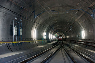
The Gotthard Base Tunnel is a railway tunnel through the Alps in Switzerland. It opened in June 2016 and full service began the following December. With a route length of 57.09 km (35.5 mi), it is the world's longest railway and deepest traffic tunnel and the first flat, low-level route through the Alps. It lies at the heart of the Gotthard axis and constitutes the third tunnel connecting the cantons of Uri and Ticino, after the Gotthard Tunnel and the Gotthard Road Tunnel.

The Gotthard Road Tunnel in Switzerland runs from Göschenen in the canton of Uri at its northern portal, to Airolo in Ticino to the south, and is 16.9 kilometres (10.5 mi) in length below the St Gotthard Pass, a major pass of the Alps. At time of construction, in 1980, it was the longest road tunnel in the world; it is currently the fifth-longest. Although it is a motorway tunnel, part of the A2 from Basel to Chiasso, it consists of only one bidirectional tube with two lanes. With a maximum elevation of 1,175 metres (3,855 ft) at the tunnel's highest point, the A2 motorway has the lowest maximum elevation of any direct north-south road through the Alps.
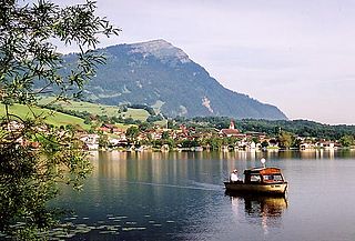
The Rigi is a mountain massif of the Alps, located in Central Switzerland. The whole massif is almost entirely surrounded by the water of three different bodies of water: Lake Lucerne, Lake Zug and Lake Lauerz. The range is in the Schwyzer Alps, and is split between the cantons of Schwyz and Lucerne, although the main summit, named Rigi Kulm, at 1,798 meters above sea level, lies within the canton of Schwyz. The Rigi Kulm Hotel, established in 1816, is located on the summit.

The Gotthard Pass or St. Gotthard Pass at 2,106 m (6,909 ft) is a mountain pass in the Alps traversing the Saint-Gotthard Massif and connecting northern Switzerland with southern Switzerland. The pass lies between Airolo in the Italian-speaking canton of Ticino, and Andermatt in the German-speaking canton of Uri, and connects further Bellinzona and Lugano to Lucerne, Basel, and Zurich. The Gotthard Pass lies at the heart of the Gotthard, a major transport axis of Europe, and it is crossed by three traffic tunnels, each being the world's longest at the time of their construction: the Gotthard Rail Tunnel (1882), the Gotthard Road Tunnel (1980) and the Gotthard Base Tunnel (2016). With the Lötschberg to the west, the Gotthard is one of the two main north-south routes through the Swiss Alps.

Monte Rosa is a mountain massif in the eastern part of the Pennine Alps, on the border between Italy and Switzerland (Valais). The highest peak of the massif, amongst several peaks of over 4.000 m, is the Dufourspitze, the second highest mountain in the Alps and western Europe, after Mont Blanc. The east face of the Monte Rosa towards Italy has a height of about 2.400 meters and is the highest mountain wall of the Alps.
The Mont Blanc massif is a mountain range in the Alps, located mostly in France and Italy, but also straddling Switzerland at its northeastern end. It contains eleven major independent summits, each over 4,000 metres (13,123 ft) in height. It is named after Mont Blanc, the highest point in western Europe and the European Union. Because of its considerable overall altitude, a large proportion of the massif is covered by glaciers, which include the Mer de Glace and the Miage Glacier – the longest glaciers in France and Italy, respectively.
The Rheinwaldhorn is the highest point in the Swiss canton of Ticino at 3,402 metres above sea level. It lies on the border between the cantons of Graubünden and Ticino, in the Adula massif, part of the St. Gotthard massif of the Lepontine Alps in southern Switzerland.

The Kander is a river in Switzerland. It is 44 kilometres (27 mi) long and has a watershed of 1,126 square kilometres (435 sq mi). Originally a tributary of the Aare, with a confluence downstream of the city of Thun, since 1714 it flows into Lake Thun upstream of the city.

Mattmark dam is a reservoir in the Saas Valley of the Canton of Valais, Switzerland. The Mattmark dam was built from 1960 to 1965. The lake's surface area is 1.76 km2 (0.68 sq mi).

The Dunantspitze, formerly called Ostspitze, is a peak of the Monte Rosa Massif in the Pennine Alps in Switzerland. It is the second highest peak of the massif, after the Dufourspitze (4,634 m) and the second highest summit in Switzerland, but its prominence is only about 15 metres. At the time of its first ascent it was unclear which of the summits was the higher.

The Conservative Democratic Party of Switzerland was a conservative political party in Switzerland from 2008 to 2020. After the 2019 federal election, the BDP had three members in the National Council.

The Monte Rosa Hut is a mountain hut located near Zermatt on the Monte Rosa massif and above the Grenzgletscher sitting on a glacier-free rocky part called Untere Plattje at an altitude of 2,883 metres (9,459 ft). It is owned by the Swiss Alpine Club. The hut is the start of the normal route to the summit and other mountains in the area. The first hut was built in 1894–1895 just next to the then still much higher Border Glacier at an altitude of 2,795 metres (9,170 ft). A completely new building was inaugurated in 2009, a hi-tech, energy-wise almost self-sufficient, environmentally friendly mountain hut based on wood with an aluminium shell.

Ulrich "Ueli" Maurer is a Swiss politician who served as a Member of the Swiss Federal Council from 2009 to 2022. A member of the Swiss People's Party (SVP/UDC), he was President of the Swiss Confederation in 2013 and 2019. Formerly head of the Federal Department of Defence, Civil Protection and Sports (2009–2015), Maurer has headed the Federal Department of Finance from 2016 to 2022. Until 2022, he has been the longest-serving current member of the Federal Council since Doris Leuthard's resignation in 2018.

Federal elections were held in Switzerland on 18 October 2015 for the National Council and the first round of elections to the Council of States, with runoff elections to the Council of States being held in various cantons until 22 November.
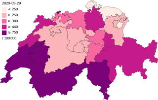
The COVID-19 pandemic in Switzerland is part of the worldwide pandemic of coronavirus disease 2019 caused by severe acute respiratory syndrome coronavirus 2. The virus was confirmed to have spread to Switzerland on 25 February 2020 when the first case of COVID-19 was confirmed following a COVID-19 pandemic in Italy. A 70-year-old man in the Italian-speaking canton of Ticino which borders Italy, tested positive for SARS-CoV-2. The man had previously visited Milan. Afterwards, multiple cases related to the Italy clusters were discovered in multiple cantons, including Basel-City, Zürich, and Graubünden. Multiple isolated cases not related to the Italy clusters were also subsequently confirmed.
