
K2, at 8,611 metres (28,251 ft) above sea level, is the second-highest mountain on Earth, after Mount Everest. It lies in the Karakoram range, partially in the Gilgit-Baltistan region of Pakistan-administered Kashmir and partially in a China-administered territory of the Kashmir region included in the Taxkorgan Tajik Autonomous County of Xinjiang.

Mount Everest is Earth's highest mountain above sea level, located in the Mahalangur Himal sub-range of the Himalayas. The China–Nepal border runs across its summit point. Its elevation of 8,848.86 m (29,031.7 ft) was most recently established in 2020 by the Chinese and Nepali authorities.
The Seven Summits are the highest mountains of each of the seven traditional continents. Climbing to the summit of all of them is regarded as a mountaineering challenge, first achieved on 30 April 1985 by Richard Bass. Climbing the Seven Summits and additionally reaching the North and South poles has been dubbed the Explorers Grand Slam.

Jerimoth Hill is the highest point in the U.S. state of Rhode Island. Located in the town of Foster in the northwest of the state, the site is used as an observatory. It is also a popular destination for highpointers, and prior to 2005 was known for being difficult to access due to a local landowner who prohibited entry.

Snaefell – is the highest mountain and the only summit higher than 2,000 feet (610 m) on the Isle of Man, at 2,037 feet (620.9 m) above sea level. The summit is crowned by a railway station, cafe and several communications masts.

East Spanish Peak is a prominent mountain summit that is the lower of the two Spanish Peaks in the Rocky Mountains of North America. The 12,688-foot (3,867 m) peak is located in the Spanish Peaks Wilderness of San Isabel National Forest, 9.3 miles (14.9 km) southeast by south of the Town of La Veta, Colorado, United States, on the drainage divide between Huerfano and Las Animas counties. The Spanish Peaks are two large igneous stocks which form an eastern outlier of the Culebra Range, a subrange of the Sangre de Cristo Mountains. East Spanish Peak is higher than any point in the United States east of its longitude; it is also the easternmost point in the United States over 12,000 feet (3,700 m), 11,000 feet (3,400 m), and 10,000 feet (3,000 m) feet above sea level.
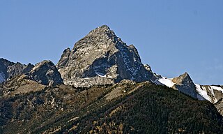
Buck Mountain 11,943 feet (3,640 m) is located in the Teton Range, Grand Teton National Park, Wyoming, immediately southeast of Grand Teton. The mountain is the highest summit south of Garnet Canyon and is easily seen from most vantage points in Jackson Hole. Views from the summit offer excellent views of the Cathedral Group to the north. The west slope of the summit tower are along the Alaska Basin Trail and extend into Caribou-Targhee National Forest and the Jedediah Smith Wilderness, which is the location of Alaska Basin, a popular wilderness camping area for backpackers. Timberline Lake is located on the eastern flanks of the peak.

The Franconia Range is a mountain range located in the White Mountains of the U.S. state of New Hampshire. It is the second-highest range of peaks in the White Mountains.

Southwest Hunter Mountain is a subpeak of Hunter Mountain, located in Greene County, New York. SW Hunter is considered one of the Catskills' High Peaks in its own right, because of its separation from the main summit, and its topographic prominence. Hunter Mountain is named after John Hunter, who also gave his name to the town of Hunter.
Saint Regis Mountain is a 2,838-foot-tall (865 m) mountain in the town of Santa Clara, New York, in Franklin County at the center of the Saint Regis Canoe Area in the Adirondack Park.

Pitchoff Mountain is a 3,600-foot (1,097 m) mountain opposite Cascade Mountain on NY 73 west of Keene Valley in Essex County, New York, in the US. There are two summits; the higher summit is viewless, but the northern summit, at 3,323 feet (1,013 m) offers 360 degree views of the nearby Cascade Lakes, the High Peaks of the Adirondacks, and, in clear weather, the Green Mountains of Vermont. There is a 5.2-mile (8.4 km) hiking trail that starts on Route 73 west of the Cascade Lakes, climbs 2.0 miles (3.2 km) to the blind summit, then traverses the nearly two-mile summit ridge to the northern summit before descending 1.4 miles (2.3 km) to Route 73 east of the Lakes, 2.7 miles (4.3 km) east of the starting point.

Mount Julian is a mountain summit in the northern Front Range of the Rocky Mountains of North America. The 12,933-foot (3,942 m) peak is located in the Rocky Mountain National Park Wilderness, 12.2 miles (19.7 km) west of the Town of Estes Park in Larimer County, Colorado, United States. The mountain was named in honor of Julian Hayden, a civil engineer who lived in Estes Park.

Mount Richthofen is the highest summit of the Never Summer Mountains range of the Rocky Mountains of North America. The prominent 12,945-foot (3,946 m) peak is located 5.6 miles (9.0 km) northwest by west of Milner Pass, Colorado, United States, on the Continental Divide separating the Rocky Mountain National Park Wilderness in Rocky Mountain National Park and Grand County from Routt National Forest and Jackson County. The mountain was named in honor of pioneering German geologist Baron Ferdinand von Richthofen, apparently by Clarence King's 1870 survey team.
Mount Alice is a high mountain summit in the northern Front Range of the Rocky Mountains of North America. The 13,315-foot (4,058 m) thirteener is located in the Rocky Mountain National Park Wilderness, 12.0 miles (19.3 km) southwest by south of the Town of Estes Park, Colorado, United States, immediately east of the Continental Divide between Boulder and Grand counties. Just who the namesake Alice was is unclear, but according to one source she was likely a "woman of ill repute".

Grizzly Peak is a high mountain summit in the Front Range of the Rocky Mountains of North America. Also known as Grizzly Peak D, the 13,433-foot (4,094 m) thirteener is located in Arapaho National Forest, 2.1 miles (3.4 km) southeast by east of Loveland Pass, Colorado, United States, on the Continental Divide between Clear Creek and Summit counties. Its proximate parent peak is Torreys Peak.

Mount Parnassus is a high mountain summit in the Front Range of the Rocky Mountains of North America. The 13,580-foot (4,139 m) thirteener is located in Arapaho National Forest, 5.4 miles (8.7 km) west-northwest of the Town of Silver Plume in Clear Creek County, Colorado, United States.
Croseus Peak at 10,388 feet (3,166 m) above sea level is a peak in the White Cloud Mountains of Idaho. The peak is located in Sawtooth National Recreation Area in Custer County. Croseus has a second summit at 10,288 ft (3,136 m), which is often marked as the primary and highest summit on maps.
Mount Emmons is a mountain summit in the Elk Mountains range of the Rocky Mountains in north-central Gunnison County, Colorado, United States.

