
The Alps are the highest and most extensive mountain range system that lies entirely in Europe, stretching approximately 750 mi (1,210 km) across eight Alpine countries : France, Switzerland, Monaco, Italy, Liechtenstein, Austria, Germany, and Slovenia.

The Alpine region of Switzerland, conventionally referred to as the Swiss Alps, represents a major natural feature of the country and is, along with the Swiss Plateau and the Swiss portion of the Jura Mountains, one of its three main physiographic regions. The Swiss Alps extend over both the Western Alps and the Eastern Alps, encompassing an area sometimes called Central Alps. While the northern ranges from the Bernese Alps to the Appenzell Alps are entirely in Switzerland, the southern ranges from the Mont Blanc massif to the Bernina massif are shared with other countries such as France, Italy, Austria and Liechtenstein.

The Bernese Alps are a mountain range of the Alps, located in western Switzerland. Although the name suggests that they are located in the Berner Oberland region of the canton of Bern, portions of the Bernese Alps are in the adjacent cantons of Valais, Fribourg and Vaud, the latter being usually named Fribourg Alps and Vaud Alps respectively. The highest mountain in the range, the Finsteraarhorn, is also the highest point in the canton of Bern.

The Tödi, is a mountain massif and with the mountain peak Piz Russein the highest mountain in the Glarus Alps and the highest summit in the canton of Glarus, Switzerland. It is located on the border between the cantons of Graubünden, to the south, and Glarus, to the north, close to the point where those two cantons meet the canton of Uri, to the west. Although not the culminating point of Graubünden, it is its highest peak outside the Bernina range.

Piz Bernina is the highest mountain in the Eastern Alps, the highest point of the Bernina Range, and the highest peak in the Rhaetian Alps. It rises 4,048.6 m (13,283 ft) and is located south of Pontresina and near the major Alpine resort of St. Moritz, in the Engadin valley. It is also the most easterly mountain higher than 4,000 m (13,000 ft) in the Alps, the highest point of the Swiss canton of Graubünden, and the fifth-most prominent peak in the Alps. Although the summit lies within Switzerland, the massif is on the border with Italy. The "shoulder" known as La Spedla is the highest point in the Italian Lombardy region.

Monte Rosa is a mountain massif in the eastern part of the Pennine Alps. It is between Italy's and Switzerland's (Valais). Monte Rosa is the second highest mountain in the Alps and western Europe, after Mont Blanc.
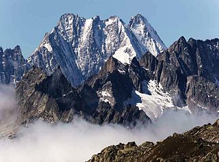
The Lauteraarhorn is a peak of the Bernese Alps, located in the canton of Bern. Together with the higher Schreckhorn, to which it is connected by a high ridge, it lies between the valleys of the Lower Grindelwald Glacier and the Unteraar Glacier, about 10 kilometres southeast of Grindelwald, the closest locality. The Lauteraarhorn belongs to the Aaremassif and is surrounded by large glaciers: the Lauteraargletscher and the Strahlegg-Gletscher and the Obers Ischmeer. Being off the main ridge of the Bernese Alps, all the glaciers surrounding the Lauteraarhorn and the Schreckhorn are part of the Aare basin. The Lauteraarhorn is the second highest summit lying wholly within the canton of Bern. Administratively, it is split between the municipalities of Grindelwald and Guttannen.

Castor is a mountain in the Pennine Alps on the border between Valais, Switzerland and the Aosta Valley in Italy. It is the higher of a pair of twin peaks, the other being Pollux, named after the Gemini twins of Roman mythology. Castor's peak is at an elevation of 4,223 m (13,855 ft), and it lies between Breithorn and the Monte Rosa. It is separated from Pollux by a pass at 3,847 m (12,621 ft), named Passo di Verra in Italian and Zwillingsjoch in German.

The Oberaarhorn is a mountain of the Bernese Alps, located on the border between the Swiss cantons of Valais and Bern. Its summit is the tripoint between the basins of the Fiesch (Valais), Unteraar and Oberaar Glacier (Bern).

The Bärglistock is a mountain of the Bernese Alps, located east of Grindelwald in the Bernese Oberland. The mountain is the tripoint between the valleys of the Upper Grindelwald Glacier, the Unteraar Glacier and the Gauli Glacier.

The Hienderstock is a mountain in the Bernese Alps, located between the Gauli Glacier and the Unteraar Glacier, in the canton of Bern. Its main summit has an elevation of 3,307 metres above sea level.

The Bächlistock is a mountain of the Bernese Alps, overlooking the Unteraar Glacier in the canton of Bern. Its summit has an elevation of 3,247 metres above sea level and is the tripoint between the glacier valleys of Hiendertelltigletscher, Bächligletscher and Unteraar.
The Scheuchzerhorn is a mountain of the Bernese Alps, located west of the Grimsel Pass in the canton of Bern. It lies north-east of the Oberaarhorn, on the range separating the valley of the Unteraar Glacier from the valley of the Oberaar Glacier.
The Sidelhorn is a mountain of the Bernese Alps, located west of the Grimsel Pass. It lies at the eastern end of the mountain chain between the Unteraar Glacier and the Rhone valley, named Aargrat. Because the glacier drains into the Aar and hence the Rhine and North Sea, whilst the Rhone flows into the Mediterranean Sea, the Sidelhorn lies on the European continental divide.

The Studerhorn is a mountain of the Bernese Alps, located on the border between the Swiss cantons of Bern and Valais. It lies between the Finsteraarhorn and the Oberaarhorn, on the ridge separating the basins of the Unteraar Glacier (north) and the Fiescher Glacier (south).

The Klein Lauteraarhorn is a peak of the Bernese Alps, overlooking the Unteraar Glacier in the canton of Bern. It lies south of the Lauteraarhorn, on the range separating the Strahlegg Glacier from the Lauteraar Glacier, both tributaries of the Unteraar Glacier.
The Brandlammhorn is a mountain of the Bernese Alps, overlooking the Unteraar Glacier and Lake Grimsel in the canton of Bern. It lies on the range east of the Bächlistock, which separates the Bächlital from the Unteraar valley.
The Lauteraar Rothörner are a multi-summited mountain of the Bernese Alps, overlooking the Unteraar Glacier in the canton of Bern. They lie one kilometre south-east of the Hugihorn, on the range separating the Strahlegg Glacier from the Lauteraar Glacier, both tributaries of the Unteraar Glacier.
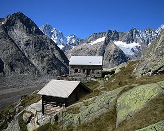
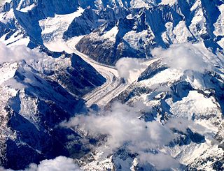
The Lauteraar Hut is a mountain hut of the Swiss Alpine Club, located south-west of Handegg in the canton of Bern. The hut lies at a height of 2,392 metres (7,848 ft) above sea level, above the Unteraar Glacier, at the foot of the Hienderstock in the Bernese Alps.

