
The Bernese Alps are a mountain range of the Alps, located in western Switzerland. Although the name suggests that they are located in the Berner Oberland region of the canton of Bern, portions of the Bernese Alps are in the adjacent cantons of Valais, Fribourg and Vaud, the latter being usually named Fribourg Alps and Vaud Alps respectively. The highest mountain in the range, the Finsteraarhorn, is also the highest point in the canton of Bern.
Galdhøpiggen is the highest mountain in Norway, Scandinavia, and Northern Europe. The 2,469-metre-tall (8,100 ft) mountain is located in Lom Municipality in Innlandet county, Norway. It is in the Jotunheimen mountains within Jotunheimen National Park. The mountain sits about 25 kilometres (16 mi) southwest of the village of Fossbergom and about 45 kilometres (28 mi) northeast of the village of Øvre Årdal. The mountain is surrounded by several other notable mountains including Keilhaus topp to the east; Store Styggehøe to the southeast; Svellnosbreahesten, Midtre Tverråtinden, and Store Tverråtinden to the south; Storjuvtinden and Skardstinden to the west; Veslpiggen, Storgrovtinden, and Storgrovhøe to the northwest; and Galdhøi and Juvvasshøi to the northeast.

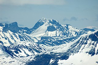
The Finsteraarhorn is a mountain lying on the border between the cantons of Bern and Valais. It is the highest mountain of the Bernese Alps and the most prominent peak of Switzerland. The Finsteraarhorn is the ninth-highest mountain and third-most prominent peak in the Alps. In 2001 the whole massif and surrounding glaciers were designated as part of the Jungfrau-Aletsch World Heritage Site.
Glittertind or Glittertinden is a mountain in Lom Municipality in Innlandet county, Norway. The 2,452-metre (8,045 ft) tall mountain is the second highest mountain in Norway. It is located in the Jotunheimen mountains within Jotunheimen National Park. The mountain sits about 22 kilometres (14 mi) southeast of the village of Fossbergom and about 38 kilometres (24 mi) southwest of the village of Vågåmo. The mountain is surrounded by several other notable mountains including Trollsteineggje, Trollsteinrundhøe, and Svartholshøe to the north; Grotbreahesten to the northeast; Veslekjølen to the east; Austre Hestlægerhøe and Nautgardstinden to the southeast; Steinbukampen and Veopallan to the south; and Galdhøpiggen to the west.

The Klein Matterhorn is a peak of the Pennine Alps, overlooking Zermatt in the Swiss canton of Valais. At 3,883 metres (12,740 ft) above sea level, it is the highest place in Europe that can be reached by aerial tramway or gondola lift, as well as by any other means of transport. The Klein Matterhorn is part of the Breithorn massif and overlooks on its south side the almost equally high flat glacier named Breithorn Plateau, just north of the international border with Italy. The name "Klein Matterhorn" is a reference to its much larger neighbour, the Matterhorn, which lies 7 km (4.3 mi) away across the Theodul Pass.

The Aletschhorn is a mountain in the Alps in Switzerland, lying within the Jungfrau-Aletsch region, which has been designated a World Heritage Site by UNESCO. The mountain shares part of its name with the Aletsch Glacier lying at its foot.

Mount Lyell is the highest point in Yosemite National Park, at 13,114 feet (3,997 m). It is located at the southeast end of the Cathedral Range, 1+1⁄4 miles northwest of Rodgers Peak. The peak as well as nearby Lyell Canyon is named after Charles Lyell, a well-known 19th century geologist. The peak had one of the last remaining glaciers in Yosemite, Lyell Glacier. The Lyell Glacier is currently considered to be a permanent ice field, not a living glacier. Mount Lyell divides the Tuolumne River watershed to the north, the Merced to the west, and the Rush Creek drainage in the Mono Lake Basin to the southeast.

Titlis is a mountain of the Uri Alps, located on the border between the cantons of Obwalden and Bern. At 3,238 metres (10,623 ft) above sea level, it is the highest summit of the range north of the Susten Pass, between the Bernese Oberland and Central Switzerland. It is mainly accessed from Engelberg (OW) on the north side and is famous as the site of the world's first rotating cable car. The cable car system connects Engelberg to the summit of Klein Titlis through the three stages of Gerschnialp, Trübsee and Stand. In 2016, a direct route was created that bypassed Geraschnialp, going directly to Trübsee.
The Lauteraarhorn is a peak of the Bernese Alps, located in the canton of Bern. Together with the higher Schreckhorn, to which it is connected by a high ridge, it lies between the valleys of the Lower Grindelwald Glacier and the Unteraar Glacier, about 10 kilometres southeast of Grindelwald, the closest locality. The Lauteraarhorn belongs to the Aaremassif and is surrounded by large glaciers: the Lauteraargletscher and the Strahlegg-Gletscher and the Obers Ischmeer. Being off the main ridge of the Bernese Alps, all the glaciers surrounding the Lauteraarhorn and the Schreckhorn are part of the Aare basin. The Lauteraarhorn is the second highest summit lying wholly within the canton of Bern. Administratively, it is split between the municipalities of Grindelwald and Guttannen.

The Oberaarhorn is a mountain of the Bernese Alps, located on the border between the Swiss cantons of Valais and Bern. Its summit is the tripoint between the basins of the Fiesch (Valais), Unteraar and Oberaar Glacier (Bern).

The Bärglistock is a mountain of the Bernese Alps, located east of Grindelwald in the Bernese Oberland. The mountain is the tripoint between the valleys of the Upper Grindelwald Glacier, the Unteraar Glacier and the Gauli Glacier. Southeast of Bärglistock, separated by a deep notch, lies the Sub-Peak Ankenbälli.

The Hienderstock is a mountain in the Bernese Alps, located between the Gauli Glacier and the Unteraar Glacier, in the canton of Bern. Its main summit has an elevation of 3,307 metres above sea level.

The Bächlistock is a mountain of the Bernese Alps, overlooking the Unteraar Glacier in the canton of Bern. Its summit has an elevation of 3,246 metres above sea level and is the tripoint between the glacier valleys of Hiendertelltigletscher, Bächligletscher and Unteraar.
The Sidelhorn is a mountain of the Bernese Alps, located west of the Grimsel Pass. It lies at the eastern end of the mountain chain between the Unteraar Glacier and the Rhone valley, named Aargrat. Because the glacier drains into the Aar and hence the Rhine and North Sea, whilst the Rhone flows into the Mediterranean Sea, the Sidelhorn lies on the European continental divide.
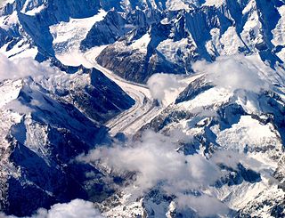
The Aargletschers, literally "Aare-Glaciers", are a system of glaciers located at the sources of the Aare river in the Bernese Alps, Switzerland. In the original German the name is "Aargletscher" both in singular and plural, as in German the plural of "gletscher" is only marked by a change of the article: der Gletscher, die Gletscher. The Aargletschers are constituted by two distinct partial glacier systems:

The Hugihorn is a peak of the Bernese Alps, overlooking the Unteraar Glacier in the canton of Bern. It lies south of the Klein Lauteraarhorn, on the range separating the Strahlegg Glacier from the Lauteraar Glacier, both tributaries of the Unteraar Glacier.
The Lauteraar Rothörner are a multi-summited mountain of the Bernese Alps, overlooking the Unteraar Glacier in the canton of Bern. They lie one kilometre south-east of the Hugihorn, on the range separating the Strahlegg Glacier from the Lauteraar Glacier, both tributaries of the Unteraar Glacier.
The Nasse Strahlegg is a peak of the Bernese Alps, located east of the Finsteraarjoch in the canton of Bern. It is the culminating point of the small range descending from the south-west ridge of the Lauteraarhorn, between the valleys of the Lower Grindelwald Glacier and the Unteraar Glacier.
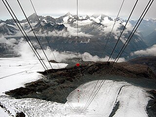
The Theodul Glacier is a glacier of the Alps, located south of Zermatt in the canton of Valais. It lies on the Swiss side of the Pennine Alps, although its upper basin touches the Italian region of the Aosta Valley. The glacier descends from the west side of the Breithorn and splits into two diverging branches above Gandegg: the Upper Theodul Glacier, spilling on a high plateau near Trockener Steg, together with the Furgg Glacier, and the Lower Theodul Glacier, reaching a height of about 2,500 metres (8,202 ft) above the Gorner Glacier.


