Mont Collon

Last updated
Mont Collon
MontCollon.jpg
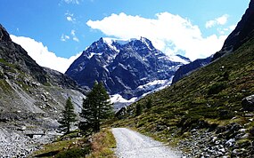
The north face of Mont Collon from the Arolla valley
Highest point
Elevation 3,637 m (11,932 ft)
Prominence 208 m (682 ft) [1]
Parent peak L'Evêque
Coordinates 45°58′35″N7°30′17″E / 45.97639°N 7.50472°E / 45.97639; 7.50472 Coordinates: 45°58′35″N7°30′17″E / 45.97639°N 7.50472°E / 45.97639; 7.50472
Geography
Switzerland relief location map.jpg
Red triangle with thick white border.svg
Mont Collon
Location in Switzerland
Location Valais, Switzerland
Parent range Pennine Alps
Climbing
First ascent 31 July 1867 by George Edward Foster, Hans Baumann and Johann Kronig [2]

Mont Collon (3,637 m) is a mountain of the Swiss Pennine Alps in the canton of Valais. Its glaciated north face dominates the view south from the village of Arolla.

The ascent over the West Ridge, first made by A. Cust and F. Gardiner with the guides Peter Knubel and Johannes Knubel of St. Niklaus in the canton Valais on 3 August 1876, is now the normal route.

Related Research Articles

Dom (mountain) Mountain in the Pennine Alps, Switzerland

The Dom is a mountain of the Pennine Alps, located between Randa and Saas-Fee in the canton of Valais in Switzerland. With a height of 4,545 m (14,911 ft), it is the seventh highest summit in the Alps, overall. Based on prominence, it can be regarded as the third highest mountain in the Alps, and the second highest in Switzerland, after Monte Rosa. The Dom is the main summit of the Mischabel group, which is the highest massif lying entirely in Switzerland.

Grand Combin Mountain massif in the western Pennine Alps, in the Swiss canton of Valais

The Grand Combin is a mountain massif in the western Pennine Alps in the canton of Valais. At a height of 4,314 metres (14,154 ft) the summit of Combin de Grafeneire is one of the highest peaks in the Alps and the second most prominent of the Pennine Alps. The Grand Combin is also a large glaciated massif consisting of several summits, among which three are above 4000 metres. The highest part of the massif is wholly in Switzerland, although the border with Italy lies a few kilometres south.

Arolla Village in the canton of Valais in Switzerland

Arolla is a village in the municipality of Evolène in the canton of Valais in Switzerland.

Val dHérens

Val d'Hérens is an alpine valley in the Valais canton of Switzerland. It was formed by the Hérens glacier, which retreated at the end of the last ice age. It is now the valley of the Borgne river, a tributary of the Rhone

St. Niklaus, Switzerland Municipality in Switzerland in Valais

St. Niklaus is a village and a municipality in the Mattertal, part of the district of Visp in the canton of Valais in Switzerland.

Mont Blanc de Cheilon Mountain in Switzerland

Mont Blanc de Cheilon is a mountain of the Pennine Alps, located in the Swiss canton of Valais. The mountain lies between the valleys of Bagnes and Arolla. Culminating at 3,870 metres above sea level, it is one of the highest summits between the Grand Combin to the west and the Dent Blanche to the east. The massif is glaciated, with the Cheilon Glacier to the north, the Giétro Glacier to the west, the Brenay Glacier to the south and the Tsijiore Nouve Glacier to the east.

Weisshorn Mountain in the Pennine Alps

The Weisshorn is a major peak of Switzerland and the Alps, culminating at 4,506 metres above sea level. It is part of the Pennine Alps and is located between the valleys of Anniviers and Zermatt in the canton of Valais. In the latter valley, the Weisshorn is one of the many 4000ers surrounding Zermatt, with Monte Rosa and the Matterhorn.

Horace Walker English mountaineer

Horace Walker (1838–1908) was an English mountaineer who made many notable first ascents, including Mount Elbrus and the Grandes Jorasses.

Wildhorn Mountain in Switzerland

The Wildhorn is a mountain of the Alps, straddling the border between the Swiss cantons of Bern and Valais. At 3,248 metres (10,656 ft) above sea level, it is the highest summit of the Bernese Alps west of the Gemmi Pass. It forms a large glaciated massif, about 10 km wide, extending between the Sanetsch Pass and the Rawil Pass. Along with the Muverans, the Diablerets and the Wildstrubel, the Wildhorn is one of the four distinct mountain massifs of the Bernese Alps that lie west of the Gemmi Pass. The massif of the Wildhorn is at the centre between the valleys of the Saane, Simme and the Rhone (Valais). It comprises several distinct summits, including the Arpelistock, Le Sérac, the Geltenhorn, the Sex Noir, the Sex Rouge, the Schnidehorn and the Six des Eaux Froides. The main crest is between the glaciers named Tungelgletscher and Glacier du Wildhorn. South of the main summit is the almost equally high summit of Mont Pucel. The Wildhorn is surrounded by several large mountain lakes: the Lac de Sénin, the Lauenensee, the Iffigsee, the Lac de Tseuzier and the Lac des Audannes. The Tungelgletscher, on the north-east face, was measured as 1.9 km in length in 1973.

Mont Vélan Mountain in Switzerland/Italy

Mont Vélan is a mountain of the Pennine Alps, located on the border between Switzerland and Italy. At 3,727, metres Mont Vélan is the highest summit lying between the Great St Bernard Pass and Grand Combin. Two large glaciers cover its northern flanks: Glacier de Tseudet (west) and Glacier de Valsoray (east). The Glacier de Proz, lying on the west side, was traversed during the first ascent.

Petit Mont Collon Mountain in Switzerland

The Petit Mont Collon is a mountain of the Swiss Pennine Alps, located south of Arolla in the canton of Valais. It lies south of the Col de Chermotane and west of Mont Collon.

LEvêque Mountain in Switzerland

L'Evêque is a mountain of the Pennine Alps, overlooking the Col Collon in the canton of Valais, south of Mont Collon. With a height of 3,716 meters above sea level, it is one of the highest summits in the Arolla valley.

Col Collon Mountain pass across the central Pennine Alps

Col Collon is a high mountain pass across the central Pennine Alps, connecting Arolla in the Swiss canton of Valais to Bionaz in the Italian region of Aosta Valley.

Aiguille du Grépon Mountain in the Mont Blanc Massif in Haute-Savoie, France

The Aiguille du Grépon, informally known as The Grepon, is a mountain in the Mont Blanc Massif in Haute-Savoie, France. The Grepon has a Southern and Northern peak, which are the highest points of a sharp granite ridge to the east of the Glacier des Nantillons above Chamonix and northeast of the Aiguille du Midi. A madonna statue is situated on the Southern peak.

Pic Luigi Amedeo Mountain in the Mont Blanc massif in the Val dAosta, Italy

Pic Luigi Amedeo is a mountain in the Mont Blanc massif in the Val d'Aosta, Italy. It lies on the Brouillard ridge to the summit of Mont Blanc, and is only reachable via an ascent of that ridge.

Thyon

Thyon is a purpose-built ski resort in the Swiss Alps, located in the canton of Valais. The resort is situated in the central part of the canton, in the region of Sion, and is associated with the village of Les Collons. It forms part of the "4 Valleys" interlinked ski area, which together includes Thyon, Veysonnaz, Haute-Nendaz, Verbier and La Tzoumaz. The ski pistes from Thyon and Veysonnaz effectively constitute a large, single integrated ski area, and connect with the rest of the "4 Valleys" area.

Josef Knubel was a Swiss mountaineer and mountain guide. He made many first ascents and other climbs in the Alps during his career. He is best known for his ascents as a guide for Geoffrey Winthrop Young.

References

  1. Retrieved from the Swisstopo topographic maps. The key col is located south of the mountain at 3,429 metres.
  2. Note on first ascent by Foster, The Alpine Journal, Volume 4, 1868, Page 56