
The Col du Galibier is a mountain pass in the southern region of the French Dauphiné Alps near Grenoble. It is the eighth highest paved road in the Alps, and recurrently the highest point of the Tour de France.
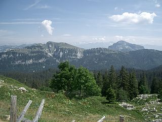
The Chartreuse Mountains are a mountain range in southeastern France, stretching from the city of Grenoble in the south to the Lac du Bourget in the north. They are part of the French Prealps, which continue as the Bauges to the north and the Vercors to the south.

The mountains of the Massif des Écrins form the core of Écrins National Park in Hautes-Alpes and Isère in the French Alps.

The Aravis is a mountain range in Savoie and Haute-Savoie, eastern France. It is part of the French Prealps, a lower chain of mountain ranges west of the main chain of the Alps. Its highest summit is the Pointe Percée, at 2753m. The orientation of the Aravis is north–

The Bauges Mountains is a mountain range in Auvergne-Rhône-Alpes, Eastern France, stretching from the city of Annecy, Haute-Savoie to the city of Chambéry, Savoie, which is part of the French Prealps.

Modane is a commune in the Savoie department in the Auvergne-Rhône-Alpes region in southeastern France.

The Vanoise massif is a mountain range of the Graian Alps, located in the Western Alps. After the Mont Blanc Massif and the Écrins Massif it is the third-highest massif in France, reaching a height of 3,885 m at the summit of Grande Casse. It lies between Tarentaise Valley to the north and the Maurienne Valley in the south. The range is the site of France's first national park, established in 1963, Vanoise National Park. The ski resorts of Tignes and Val-d'Isère and the 2,770-metre-high Col de l'Iseran are located in the eastern part of the range.
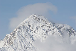
Mont Chaberton is a 3,131 metres (10,272 ft) peak in the French Alps in the group known as the Massif des Cerces in the département of Hautes-Alpes.

The Vallée de la Clarée is a scenic valley in the French Alps near to Montgenèvre, Briançon and the French-Italian border. The Clarée river runs through the valley.

The Fortified Sector of the Dauphiné was the French military organization that in 1940 controlled the section of the Alpine Line portion of the Maginot Line facing Italy in the vicinity of Briançon. By comparison with the integrated defenses of the main Maginot Line, or even of the Fortified Sector of the Maritime Alps to the south, the Dauphiné sector consisted of a series of distinct territories that covered two main invasion routes into France: the route from Turin over the Col de Montgenèvre to Briançon and Grenoble, and the route from Coni over the Col de Larche to Barcelonette and Gap. The sector was the scene of probing attacks by Italian forces during the Italian invasion of France in 1940, in which the French defenses successfully resisted Italian advances until the June 1940 armistice that granted Italy access to southeastern France.

Mont Thabor is a mountain of Savoie and Hautes-Alpes, France. It lies in the Massif des Cerces range. It has an elevation of 3,178 metres above sea level, it stands close to another summit, the Pic du Thabor, culminating at 3,207 metres above sea level.

The Glacier Noir is a glacier in the Massif des Écrins in the French Alps. It is located in the département of Hautes-Alpes.
The Bornes Massif is a mountainous massif in the north French Prealps in the department of Haute-Savoie. It has 20 peaks higher than 2000 m and is a popular destination for winter sports. The Massif is the source of the celebrated cheese Reblochon.
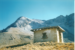
Roche Méane is a two-summit peak in the Massif des Écrins in the French Alps. It is located on the crest between Barre des Écrins and La Meije. The west summit is 3,728 metres (12,231 ft) high and is called Pic Maître; it is on the border between the Provence-Alpes-Côte d'Azur region of the département of Hautes-Alpes and the Rhône-Alpes region of the département of Isère. The east summit is 3,712 metres (12,178 ft) high and is entirely within Hautes-Alpes. The two summits are located in the small massif of La Grande Ruine, the highest summit of which is that of Pointe Brevoort, which is next to Roche Méane. Below the summits are rocky cliffs and three glaciers: the Clot des Cavales, the Grande Ruine glacier, and the Supérieur des Agneaux. In 1907 Baedeker described the mountain as a "very difficult" two-and-a-half-hour ascent from this last.
The Pic du Thabor is a mountain of Savoie and Hautes-Alpes, France. It lies in the Massif des Cerces range. It has an elevation of 3,207 metres above sea level, it stands closed to another summit, the Mont Thabor, culminating at 3,178 metres above sea level.
On 18 January 2016, six French Foreign Legionnaires were killed in an avalanche in the Massif des Cerces, France.

Grand Galibier is a mountain of the Cottian Alps in Savoie, France.
The Pointe Rochers Charniers is a mountain of the Cottian Alps at an elevation of 3,063 metres above sea level, located in France.

The Mont Mézenc is a mountain range in the Massif Central, bordering the departments of Ardèche and Haute-Loire, making up a natural region of France. Its highest point is Mount Mézenc, whose two summits, South and North, are respectively the highest in Ardèche at 1,753 meters and Haute-Loire at 1,744 meters.
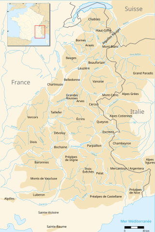
The Nice Prealps are a massif in the southern part of the French Prealps located mainly in the south-east of the French department of Alpes-Maritimes and, for a very small part, in the Italian region of Liguria between the Roya river and the Franco-Italian border.

