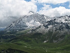
The Graian Alps are a mountain range in the western part of the Alps.
Savoie is a department in the Auvergne-Rhône-Alpes region, Southeastern France. Located in the French Alps, its prefecture is Chambéry. In 2019, Savoie had a population of 436,434.

Faucigny is a commune in the Haute-Savoie department in the Auvergne-Rhône-Alpes region in south-eastern France.

Annecy is the prefecture and largest city of the Haute-Savoie department in the Auvergne-Rhône-Alpes region of Southeastern France. It lies on the northern tip of Lake Annecy, 35 kilometres (22 mi) south of Geneva, Switzerland. Nicknamed the "Pearl of French Alps" in Raoul Blanchard's monograph describing its location between lake and mountains, the city controls the northern entrance to the lake gorge. Due to a lack of available building land between the lake and the protected Semnoz mountain, its population has remained stagnant, around 50,000 inhabitants, since 1950. However, the 2017 merger with several ex-communes extended the city population to 128,199 inhabitants and 177,622 for its urban area, placing Annecy seventh in the Auvergne-Rhône-Alpes region.

Les Houches is a commune in the Haute-Savoie department in the Auvergne-Rhône-Alpes region of Eastern France. In 2017, it had a population of 2,943.

The Mont Blanc tramway or Tramway du Mont-Blanc (TMB) is a mountain railway line in the Haute-Savoie department of France. It is the highest in France and the fourth highest in Europe. It is also the only railway in France reaching over 2,000 metres above sea level.
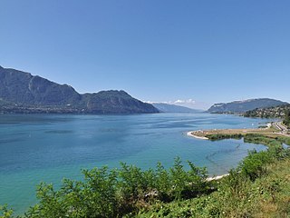
Lac du Bourget, also locally known as Lac Gris or Lac d'Aix, is a lake at the southernmost end of the Jura Mountains in the department of Savoie, France. It is the deepest lake located entirely within France, and either the largest or second largest after Lac de Grand-Lieu depending on season.

Les Contamines-Montjoie is a commune in the Haute-Savoie department in the Auvergne-Rhône-Alpes region in south-eastern France.
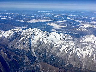
The Mont Blanc massif is a mountain range in the Alps, located mostly in France and Italy, but also straddling Switzerland at its northeastern end. It contains eleven major independent summits, each over 4,000 metres (13,123 ft) in height. It is named after Mont Blanc, the highest point in western Europe and the European Union. Because of its considerable overall altitude, a large proportion of the massif is covered by glaciers, which include the Mer de Glace and the Miage Glacier – the longest glaciers in France and Italy, respectively.

Modane is a commune in the Savoie department in the Auvergne-Rhône-Alpes region in southeastern France.
The Arve Valley is an alpine valley located in the French Haute-Savoie department. The namesake of the valley is the river at the bottom: the Arve. The valley as a whole makes up the majority of Faucigny, one of the Natural Regions of France, and one of six that make up the Savoie region.

Sixt-Fer-à-Cheval is a commune in the Haute-Savoie department within the Auvergne-Rhône-Alpes region in southeastern France. It is located at the end of the Giffre Valley.

Entremont-le-Vieux is a commune in the Savoie department in the Auvergne-Rhône-Alpes region in Southeastern France. In 2019, it had a population of 644.

Aiguille du Belvédère is a mountain of Haute-Savoie, France. It is the highest peak in the Aiguilles Rouges range of the French Prealps and has an altitude of 2,965 metres (9,728 ft) above sea level.

Mont d'Arbois is a mountain of Haute-Savoie, France. It lies in the Beaufortain Massif range, at an altitude of 1833 metres above sea level.

Aiguille de Leschaux is a mountain in the Mont Blanc massif on the border of Haute-Savoie, France and Aosta Valley, Italy.
The Bornes Massif is a mountainous massif in the north French Prealps in the département of Haute-Savoie. It has 20 peaks higher than 2000 m and is a popular destination for winter sports. The Massif is the source of the celebrated cheese Reblochon.
Venance Payot was a naturalist, glaciologist, alpine mountain-guide, scholar, author, and two-time mayor of Chamonix, France. He published a wide range of early scientific literature relating to the mountains of the Mont Blanc massif and undertook some of the earliest continued measurements of the movement of glaciers within that mountain range. He has been posthumously credited in mountaineering literature with being the youngest person to have climbed Mont Blanc, and would have been sixteen years old at the time; other sources have challenged this.

The Pionniers de Chamonix Mont-Blanc are a French ice hockey team based in Chamonix, Haute-Savoie. They play in the country's top tier, the Ligue Magnus. For their inaugural 2016–17 season, they were known as Pionniers de Chamonix-Morzine.
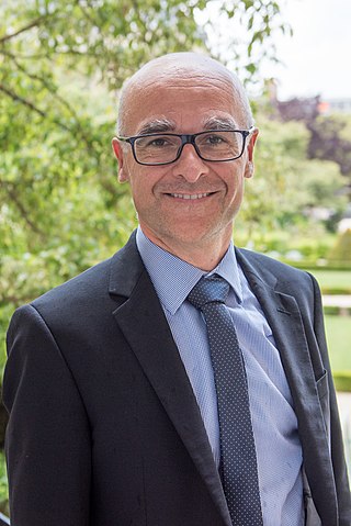
Xavier Roseren is a French politician and shopkeeper who has served as a member of the French National Assembly for Haute-Savoie's 6th constituency since 2017. He is affiliated with La République En Marche (LREM).