Its name (literally Black summit) comes from the dark colour of the shists prevailing in the mountain slopes facing Susa Valley. Also in French official maps the mountain is referred as Punta Nera.[4]
Geography
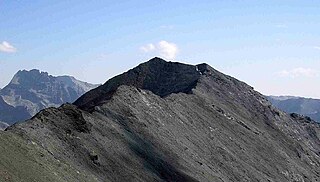
Punta Nera in summertime (SSW slopes)
The mountain is mainly made of detrital deposits and is the highest elevation of the Dora-Arcwater divide between Colle della Rho (2,541m) and Col du Fréjus (2,541m).[3] The mountain ends with two summits divided by a saddle at 3,017m; the western one is the highest (3,047m), while the eastern subsummit (3,041m) overlooks Bardonecchia and is marked by a metallic summit cross.[5] From the summit branches out a third ridge which connects the Punta Nera with the neighbouring Grand Argentier (3,042m), totally in France.
SOIUSA classification
According to SOIUSA (International Standardized Mountain Subdivision of the Alps) the mountain can be classified in the following way:[6]
Summit (on the right) and subsummmit of the Punta Nera as seen from the Grand Argentier
The normal route to access the mountain from its Italian side starts from Grange della Rho (Bardonecchia) and, after Piano dei Morti (at about 2,300m), leaves the footpath leading to the Colle della Rho and reaches the summit through its South-Western slopes, at first grassy and then bare and rocky.[5] From France the normal access route starts from Valfréjus (Modane); in wintertime some skilifts operating there can be used in order to shorten the climb.[7] The mountain is also crossed by a quite demanding ski mountaineering route connecting Col du Fréjus with Colle della Rho.[3]
1 2 Bellino Tripi, Eleonora; Ceragioli, Filippo; Molino, Aldo (2005). "Il Colle della Rho e la Punta Nera". Alta Valle di Susa. Valli e sentieri (in Italian). Torino: Vivalda. pp.155–159. ISBN8874800657.
↑ Marazzi, Sergio (2005). Atlante Orografico delle Alpi. SOIUSA (in Italian). Priuli & Verlucca. p.90. ISBN978-88-8068-273-8.
Istituto Geografico Centrale - Carta dei sentieri e dei rifugi scala 1:50.000 n. 1 Valli di Susa Chisone e Germanasca e 1:25.000 n. 104 Bardonecchia Monte Thabor Sauze d'Oulx
Punta Tre Vescovi is a peak in the Biellese Prealps, in northern Italy. On its top, three valleys meet: Lys Valley, Valsesia, and Cervo Valley.
Mont d'Ambin or Rocca d'Ambin is a mountain on the border of Savoie, France and of the Province of Turin, Italy. It lies in the Ambin group of the Cottian Alps. On the Italian side, it commands the view of the Val di Susa. It has an elevation of 3,378 metres (11,083 ft) above sea level. The Mont d'Ambin base tunnel of the Lyon–Turin rail link is being dug at its base.
Aiguille de Scolette or Pierre Menue is a mountain of Savoie (F) and of the province of Turin (I). It lies in the Cottian Alps and has an elevation of 3,506 metres above sea level.
Pointe de Paumont or Cima del Vallone is a mountain of Savoie, France and of the Province of Turin, Italy. It lies in the Cottian Alps range. It has an elevation of 3,171 metres above sea level.
Punta Bagnà or Cime du Grand Vallon is a mountain of Savoie, France and of the Province of Turin, Italy. It lies in the Cottian Alps range. It has an elevation of 3,129 metres above sea level.
Punta Sommeiller or Pointe Sommeiller is a mountain of the Province of Turin, Italy and of Savoie, France. It lies in the Cottian Alps range. It has an elevation of 3,333 metres (10,935 ft) above sea level.
Rognosa d'Etiache or Rognosa d'Étache is a mountain in the Cottian Alps on the border of Turin, Italy, and Savoie, France. It has an elevation of 3,382 metres above sea level.
Col d'Étache in French,, is a pedestrian pass across the Cottian Alps. It connects Susa Valley and Maurienne.
The Ambin group is a sub-range of the Cottian Alps located on the French-Italian border.
Monte Orsiera is a mountain in the Cottian Alps belonging to the Province of Turin (Italy).
The Punta Ramiere or Bric Froid is a mountain in the Cottian Alps belonging to the department of Hautes-Alpes (FR) and the province of Turin (IT). It's the highest peak of the long stretch of the Po/Rhone water divide starting from the Aiguille de Scolette (north) and ending with the Monviso group (south).
Bric Ghinivert or Eiminàl is a mountain of the Cottian Alps located in Italy.
The Punta Merciantaira or Grand Glaiza is a 3,293 metres high mountain of the Cottian Alps.
The Gran Queyron or Grand Queyron is a 3,060 metres high mountain of the Cottian Alps.
Le Grand Argentier is a mountain of Savoie (France). It lies in the Cottian Alps range at an elevation of 3,042 metres (9,980 ft) above sea level.
The Colle della Rho or Col de la Roue is a mountain col at 2,541 metres (8,337 ft), at the border between the massif des Cerces and the Cottian Alps.
The Monte Civrari is a mountain of the Graian Alps, with an elevation of 2,302 m.
The Monte I Gemelli is an Alpine mountain located between Aosta Valley and Piedmont.
The Punta Lunella is a mountain of the Graian Alps, with an elevation of 2,772 m.
The Cima Ciantiplagna is a mountain in the Cottian Alps belonging to the Province of Turin (Italy).
This page is based on this Wikipedia article Text is available under the CC BY-SA 4.0 license; additional terms may apply. Images, videos and audio are available under their respective licenses.