Pointe Rochers Charniers

Last updated
Pointe Rochers Charniers
Punta Rochers Charniers
Pointe Rochers Charniers da Col Trois Freres Mineurs 27 9 2002.png
View from the Col des Trois Frères Mineurs
Highest point
Elevation 3,063 m (10,049 ft) [1]
Prominence 389 m (1,276 ft) [1] [2]
Parent peak Mont Chaberton
Listing Alpine mountains above 3000 m
Coordinates 44°59′15″N6°44′07″E / 44.98737°N 6.73520°E / 44.98737; 6.73520 Coordinates: 44°59′15″N6°44′07″E / 44.98737°N 6.73520°E / 44.98737; 6.73520
Geography
France relief location map.jpg
Red triangle with thick white border.svg
Pointe Rochers Charniers
France
Location Hautes-Alpes, France
Parent range Cottian Alps / / Massif des Cerces
Climbing
Easiest route Scrambling

The Pointe Rochers Charniers [1] is a mountain of the Cottian Alps at an elevation of 3,063 metres above sea level, [1] located in France.

Contents

Toponymy

In French rochers means rocks . The meaning of charnier is mass grave; [3] the name comes from a bloody battle between French and Spanish troops which took place close to the mountain. [4] In Italian too the mountain is referred as Punta Rochers Charniers. [5]

Geography

The mountain is part of the main chain of the Alps where it marks the Dora-Durance water divide. The main ridge continues northwards with a saddle unnamed on the official French maps which divedes the Rochers Charniers from the Punta di Chalanche Ronde (or Pointe des Grands Becs). The main chain goes on towards South with the Crête des Charniers and the Col des Trois Frères Mineurs (2.586 m), rises up to the Pic du Lauzin (2,733 m) and goes down to the Col de Montgenèvre. A third ridge branches from the Rochers Charniers connecting it, through Col du Chaberton (2.674 m), with Mont Chaberton. [1] According to French alpinistic literature the mountain is part of the Massif des Cerces, [6] while in the SOIUSA (International Standardized Mountain Subdivision of the Alps) is part of the mountain group called "Gruppo del Chaberton"/"Groupe du Chaberton" in the Northern Cottian Alps. [7]

History

The mountain from 1861 to the end of the II World War was on the Franco-Italian border but, following the Paris Peace Treaties signed on February 1947, is now totally in France. The treaty indeed moved the border east of the Rocher Charniers [1] in order to transfer to France the sovereignty of the neighbouring Mont Chaberton and its fortress. During the militarisation of the border and the construction of the Alpine Wallsome military installations were realised as a support to the Chaberton fortress. [8] A military dirt road named Strada militare di Val Morino was also built on the eastern slopes of the Rochers Charniers, in order to connect cesana with the fortress.

Access to the summit

From Claviere (Italy) or Montgenevre (Frane) the mountain is generally accessed through the Col des Trois Frères Mineurs. [5] Is also possible to reach it from Prà Claud, a village in the comune of Cesana Torinese. The climb needs some scabbling and is advisable for experienced hikers (EE - escursionisti esperti). [9] The Pointe des Rochers Charniers, when snow is stable, can also be accessed with a quite demanding ski mountaineering route; per l'accesso in sicurezza è necessaria la presenza di neve ben assestata. [10]

Maps

Related Research Articles

Cottian Alps

The Cottian Alps are a mountain range in the southwestern part of the Alps. They form the border between France and Italy (Piedmont). The Fréjus Road Tunnel and Fréjus Rail Tunnel between Modane and Susa are important transportation arteries between France and Italy (Turin).

Susa Valley

The Susa Valley is a valley in the Metropolitan City of Turin, Piedmont region of northern Italy, located between the Graian Alps in the north and the Cottian Alps in the south. It one of the longest valleys of the Italian Alps. It extends over 50 kilometres (31 mi) in an east-west direction from the French border to the outskirts of Turin. The valley takes its name from the city of Susa which lies in the valley. The Dora Riparia river, a tributary of the Po, flows through the valley.

The massif des Cerces is a region of the French Alps on the Franco-Italian border. On the French side it lies in the departements of Hautes-Alpes and Savoie.

Mont Chaberton

Mont Chaberton is a 3,131 metres (10,272 ft) peak in the French Alps in the group known as the Massif des Cerces in the département of Hautes-Alpes.

Mont dAmbin

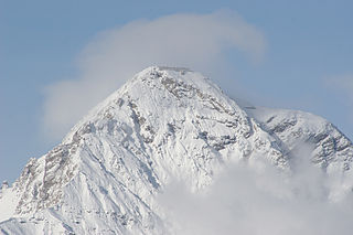
Mont d'Ambin or Rocca d'Ambin is a mountain on the border of Savoie, France and of the Province of Turin, Italy. It lies in the Ambin group of the Cottian Alps. On the Italian side, it commands the view of the Val di Susa. It has an elevation of 3,378 metres (11,083 ft) above sea level.

Pointe de Paumont

Pointe de Paumont or Cima del Vallone is a mountain of Savoie, France and of the Province of Turin, Italy. It lies in the Cottian Alps range. It has an elevation of 3,171 metres above sea level.

Punta Bagnà

Punta Bagnà or Cime du Grand Vallon is a mountain of Savoie, France and of the Province of Turin, Italy. It lies in the Cottian Alps range. It has an elevation of 3,129 metres above sea level.

Punta Sommeiller

Punta Sommeiller or Pointe Sommeiller is a mountain of the Province of Turin, Italy and of Savoie, France. It lies in the Cottian Alps range. It has an elevation of 3,333 metres (10,935 ft) above sea level.

Rognosa dEtiache

Rognosa d'Etiache or Rognosa d'Étache is a mountain in the Cottian Alps on the border of Turin, Italy, and Savoie, France. It has an elevation of 3,382 metres above sea level.

Col dÉtache

Col d'Étache in French,, is a pedestrian pass across the Cottian Alps. It connects Susa Valley and Maurienne.

Monte Orsiera

Monte Orsiera is a mountain in the Cottian Alps belonging to the Province of Turin (Italy).

Punta Ramiere

The Punta Ramiere or Bric Froid is a mountain in the Cottian Alps belonging to the department of Hautes-Alpes (FR) and the province of Turin (IT). It's the highest peak of the long stretch of the Po/Rhone water divide starting from the Aiguille de Scolette (north) and ending with the Monviso group (south).

Mont Giusalet

Mont Giusalet is a mountain in the Ambin group of the Cottian Alps in Savoie, France, near the Italian border.

Bric Ghinivert Mountain in Italy

Bric Ghinivert or Eiminàl is a mountain of the Cottian Alps located in Italy.

Monte Politri Mountain in Italy

Monte Politri or Bric Rosso is a 3,026 m a.s.l. mountain of the Cottian Alps, located in Italy.

Punta Merciantaira

The Punta Merciantaira or Grand Glaiza is a 3,293 metres high mountain of the Cottian Alps.

Grand Queyron

The Gran Queyron or Grand Queyron is a 3,060 metres high mountain of the Cottian Alps.

Punta Nera

The Punta Nera is a mountain of Savoie (France) and of the Province of Turin (Italy). It lies in the Cottian Alps range. It has an elevation of 3,047 metres above sea level.

Pointe de Bellecombe Mountain in France

The Pointe de Bellecombe is a 2,775 m high mountain of the northern Cottian Alps.

Punta Cornour Mountain in Italy

The Punta Cornour is a 2,868 metres high mountain on the Italian side of the Cottian Alps.

References

Commons-logo.svg Media related to Pointe Rochers Charniers at Wikimedia Commons

  1. 1 2 3 4 5 6 Géoportail (Map) (in French). IGN . Retrieved 2019-04-05.
  2. Key col: Col du Chaberton, 2,674 m
  3. "charnier". WordReference.com. Retrieved 2019-04-02.
  4. AA.VV. (1907). Rivista mensile del Club alpino italiano (in Italian). Club Alpino Italiano. p. 384. Retrieved 2019-04-02.
  5. 1 2 Berutto, Giulio (1988). "Punta Chalache Ronde 3042 m La Punta 3047 m Punta Rochers Charniers 3067 m". Valli di Susa Chisone e Germanasca. Guide I.G.C. (in Italian). Torino: Istituto Geografico Centrale. pp. 184–185.
  6. "Névache - Val-des-Prés - Montgenèvre - Vallée Étroite - Massif des Cerces" (in French). Vallouimages - Toponymie de la Clarée. Retrieved 2019-04-05.
  7. Marazzi, Sergio (2005). Atlante Orografico delle Alpi. SOIUSA (in Italian). Priuli & Verlucca. p. 88. ISBN   978-88-8068-273-8.
  8. Manu. "Batteria dello Chaberton" (in Italian). ICSM. Retrieved 2019-04-03.
  9. BENGIA (2010-03-09). "Rochers Charniers (Pointe des) da Prà Claud e il Pian del Morti". gulliver.it. Retrieved 2019-04-02.
  10. wuolz gio notav (2011-02-26). "Rochers Charniers (Pointe des) da Pra Claud" (in Italian). gulliver.it. Retrieved 2019-04-02.