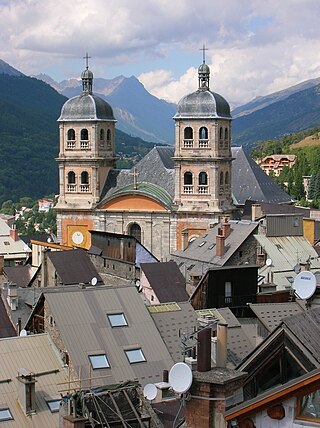
Briançon is the sole subprefecture of the Hautes-Alpes department in the Provence-Alpes-Côte d'Azur region in Southeastern France. It is the highest city in France at an altitude of 1,326 metres, based on the national definition as a community containing more than 2,000 inhabitants. Its most recent population estimate is 11,084 for the commune.

Sestriere (/se'strjɛre/) is a ski resort in Piedmont, Italy, a comune (municipality) of the Metropolitan City of Turin. It is situated in Val Susa, 17 km (11 mi) from the French border. Its name derives from Latin: ad petram sistrariam, that is at sixty Roman miles from Turin.

The Via Lattea is a winter sports area in the Italian and French Alps, straddling the French-Italian border at Claviere/Montgenèvre. Located some 70 km west of Turin, it comprises the five Piedmontese resorts of Claviere (1760m), Sansicario (1700m), Sauze d'Oulx (1509m), Pragelato (1524m) and Sestriere (2035m) and additionally the French resort Montgenèvre (1860m). Altogether there are more than 400 km of skiable pistes, 120 of them with artificial snow, and 70 lifts. The lowest lift begins at 1370m in the service village of Cesana Torinese; the highest point is Mont Motta in the Sestriere ski area, at 2800m. Claviere and Montgenèvre are connected by skiing and ski lifts. The 2006 Winter Olympics had the alpine ski events in the Via Lattea , on Sestriere and Sansicario slopes and most other snow events and bobsleigh nearby.
The Col de Montgenèvre is a high mountain pass in the Cottian Alps, in France 2 kilometres away from Italy.

Pragelato is a comune (municipality) in the Metropolitan City of Turin in the Italian region Piedmont, located about 60 kilometres (37 mi) west of Turin, in the upper Val Chisone. The name Pragelato, meaning "icy meadow", has been derived from the harsh climate and the fact that the ground is covered with ice for long periods. On both sides of the Chisone, extensive forests of pine and larch provide protection from the avalanches which are a common occurrence in the winter season: for this reason in the nineteenth century the people of Pragelato were only permitted to fell trees close to the mountain summits, and even then only with the permission of the communal administration.

Sauze d'Oulx is a town and comune in the Metropolitan City of Turin, Piedmont located 80 km from Turin in the Val di Susa, at the foot of Monte Genevris.

Turin Airport, also known as Turin-Caselle Airport, is an international airport located at Caselle Torinese, 16 km (9.9 mi) north-northwest of the city of Turin, in the Metropolitan City of Turin, Piedmont region, Northern Italy. It is also named Sandro Pertini Airport, after former Italian President Sandro Pertini.

Giaveno is a comune (municipality) in the Metropolitan City of Turin in the Italian region Piedmont, located about 30 kilometres (19 mi) west of Turin.
Angrogna is a comune (municipality) in the Metropolitan City of Turin in the Italian region Piedmont, located about 45 kilometres (28 mi) southwest of Turin.
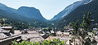
Cesana Torinese is a comune (municipality) in the Metropolitan City of Turin in the Italian region Piedmont, located about 70 kilometres (43 mi) west of Turin, on the border with France. Cesana is a popular winter ski resort, being connected to both Sansicario/Sestriere and Claviere/Montgenevre via chairlifts and gondolas. A run connecting Sagnalonga Monti della luna to Cesana is currently being renovated and will be open from 2022. During the summer, Cesana is a popular holiday destination, famous for its many trekking and alpine lakes in the neighbouring areas.

Oulx is a comune (municipality) in the Metropolitan City of Turin in the Italian region Piedmont, located about 70 kilometres (43 mi) west of Turin, in the Susa Valley on the border with France.

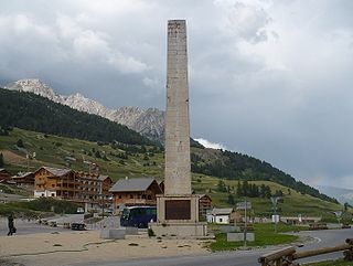
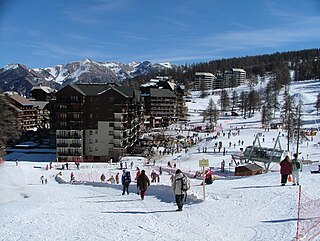
Montgenèvre is a commune on the Italian border in the Hautes-Alpes department in the Provence-Alpes-Côte d'Azur region in Southeastern France. In 2018, it had a population of 456.
Ayrens is a commune in the Cantal department in the Auvergne-Rhône-Alpes region of south-central France.
Risoul is a commune in the Hautes-Alpes department in southeastern France. It is located in the French Alps between the towns of Briançon and Gap.
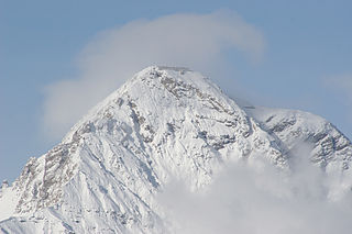
Mont Chaberton is a 3,131 metres (10,272 ft) peak in the French Alps in the group known as the Massif des Cerces in the département of Hautes-Alpes.

Oulx-Cesana-Claviere-Sestriere is a railway station in Oulx. The station is located on the Turin-Modane railway. The train services are operated by Trenitalia and SNCF.

The France–Italy border is 515 km long. It runs from the Alps in the north, a region in which it passes over Mont Blanc, down to the Mediterranean coast in the south. Three national parks are located along the border: Vanoise National Park and Mercantour National Park on the French side and Gran Paradiso National Park on the Italian side.
The Pointe Rochers Charniers is a mountain of the Cottian Alps at an elevation of 3,063 metres above sea level, located in France.

The Mount Chenaillet is a 2,650 metres high mountain of the Cottian Alps, located on the Main chain of the Alps South of the Col de Montgenèvre.

Mount Gimont is a mountain 2,646 m above sea level in the Montgenèvre Alps, in the Cottian Alps. It is located on the border between Italy and France (Hautes-Alpes).


