
Mountaineering, or alpinism, is the set of outdoor activities that involves ascending tall mountains. Mountaineering-related activities include traditional outdoor climbing, skiing and traversing via ferratas. Indoor climbing, sport climbing and bouldering are also considered variants of mountaineering by some.

The Tödi, is a mountain massif and with the mountain peak Piz Russein the highest mountain in the Glarus Alps and the highest summit in the canton of Glarus, Switzerland. It is located on the border between the cantons of Graubünden, to the south, and Glarus, to the north, close to the point where those two cantons meet the canton of Uri, to the west. Although not the culminating point of Graubünden, it is its highest peak outside the Bernina range.

The Gran Paradiso or Grand Paradis is a mountain in the Graian Alps in Italy, located between the Aosta Valley and Piedmont regions.
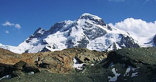
The Breithorn is a mountain range of the Pennine Alps with its highest peak of the same name, located on the border between Switzerland and Italy. It lies on the main chain of the Alps, approximately halfway between the Matterhorn and Monte Rosa and east of the Theodul Pass. Most of the massif is glaciated and includes several subsidiary peaks, all located east of the main summit: the Central Breithorn, the western Breithorn Twin, the Gendarm and the Roccia Nera. The main summit is sometimes distinguished by the name Western Breithorn. The nearest settlements are Zermatt (Valais) and St-Jacques.

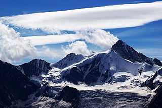
The Grossglockner is, at 3,798 metres above the Adriatic (12,461 ft), the highest mountain in Austria and the highest mountain in the Alps east of the Brenner Pass. It is part of the larger Glockner Group of the Hohe Tauern range, situated along the main ridge of the Central Eastern Alps and the Alpine divide. The Pasterze, Austria's most extended glacier, lies on the Grossglockner's eastern slope.

The Dom is a mountain of the Pennine Alps, located between Randa and Saas-Fee in the canton of Valais in Switzerland. With a height of 4,545 m (14,911 ft), it is the seventh highest summit in the Alps, overall. Based on prominence, it can be regarded as the third highest mountain in the Alps, and the second highest in Switzerland, after Monte Rosa. The Dom is the main summit of the Mischabel group, which is the highest massif lying entirely in Switzerland.

The Barre des Écrins is a mountain in the French Alps with a peak elevation of 4,102 metres (13,458 ft). It is the highest peak of the Massif des Écrins and the Dauphiné Alps and the most southerly alpine peak in Europe that is higher than 4,000 metres. It is the only 4,000-metre mountain in France that lies outside the Mont Blanc Massif. Before the annexation of Savoy in 1860 it was the highest mountain in France.

The Schreckhorn is a mountain in the Bernese Alps. It is the highest peak located entirely in the canton of Berne. The Schreckhorn is the northernmost Alpine four-thousander and the northernmost summit rising above 4,000 metres in Europe.
The Zinalrothorn is a mountain in the Pennine Alps in Switzerland. Its name comes from the village of Zinal lying on the north side and from the German word Rothorn which means Red Peak. When it was first climbed in 1864 the mountain was known locally as Moming.

The Gornergrat is a rocky ridge of the Pennine Alps, overlooking the Gorner Glacier south-east of Zermatt in Switzerland. It can be reached from Zermatt by the Gornergrat rack railway (GGB), the highest open-air railway in Europe. Between the Gornergrat railway station and the summit is the Kulm Hotel. In the late 1960s two astronomical observatories were installed in the two towers of the Kulmhotel Gornergrat. The project “Stellarium Gornergrat” is hosted in the Gornergrat South Observatory.

The Lagginhorn is a mountain in the Pennine Alps in Switzerland. It lies a few kilometres north of the slightly higher Weissmies and also close to the slightly lower Fletschhorn on the north.

The Allgäu Alps are a mountain range in the Northern Limestone Alps, located in Bavaria and Baden-Württemberg in Germany and Tyrol and Vorarlberg in Austria. The range lies directly east of Lake Constance.

The Weisshorn is a major peak of Switzerland and the Alps, culminating at 4,506 metres above sea level. It is part of the Pennine Alps and is located between the valleys of Anniviers and Zermatt in the canton of Valais. In the latter valley, the Weisshorn is one of the many 4000ers surrounding Zermatt, with Monte Rosa and the Matterhorn.

The Wetterstein mountains, colloquially called Wetterstein, is a mountain group in the Northern Limestone Alps within the Eastern Alps. It is a comparatively compact range located between Garmisch-Partenkirchen, Mittenwald, Seefeld in Tirol and Ehrwald along the border between Germany (Bavaria) and Austria (Tyrol). Zugspitze, the highest peak is at the same time the highest mountain in Germany.

The Kaiser Mountains are a mountain range in the Northern Limestone Alps and Eastern Alps. Its main ridges – are the Zahmer Kaiser and south of it the Wilder Kaiser. The mountains are situated in the Austrian province of Tyrol between the town of Kufstein and the town of St. Johann in Tirol. The Kaiser Mountains offer some of the loveliest scenery in all the Northern Limestone Alps.
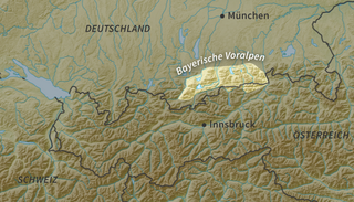
The Bavarian Prealps are a mountain range within the Northern Limestone Alps in south Germany. They include the Bavarian Prealp region between the river Loisach to the west and the river Inn to the east; the range is about 80 kilometres (50 mi) long and 20–30 kilometres (12–19 mi) wide. The term is not defined politically, but alpine-geographically because small areas of the Bavarian Prealps lie in Tyrol.
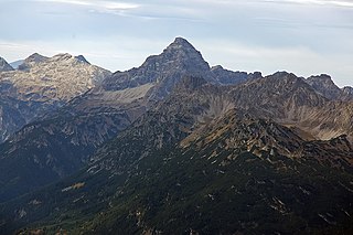
The Hochvogel is a 2,592-metre-high (8,504 ft) mountain in the Allgäu Alps. The national border between Germany and Austria runs over the summit. Although only the thirteenth highest summit in the Allgäu Alps, the Hochvogel dominates other parts of Allgäu Alps and the other ranges in the immediate neighbourhood. This is due to the fact that the majority of the higher peaks are concentrated in the central and western part of the Allgäu Alps. The Hochvogel stands on its own in the eastern part of the mountain group; the nearest neighbouring summits are 200 to 300 metres lower. Experienced climbers can ascend the summit on two marked routes.

The Hochalmspitze is located east of Mallnitz in the Austrian state of Carinthia. It is sometimes called "Tauern Queen" as a counterpart to the "Tauern King", the Grossglockner.

