Venetian Prealps

Last updated
Venetian Prealps
Alta Lessinia in inverno.jpg
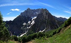
Monti Lessini in winter
Highest point
Peak Col Nudo
Elevation 2,471 m (8,107 ft) [1]
Coordinates 46°13′39″N12°24′12″E / 46.22743°N 12.40331°E / 46.22743; 12.40331 [1]
Naming
Native namePrealpi Venete (Italian)
Geography
SOIUSA-Alpi Orientali-sezione32.png
Venetian prealps (section nr.32) within Eastern Alps
Country Italy
Regions Veneto, Friuli-Venezia Giulia and Trentino-Alto Adige/Südtirol
Provinces Trento, Verona, Vicenza, Treviso, Belluno and Pordenone
Parent range Alps
Borders onBrescia and Garda Prealps, Dolomites, Carnic and Gailtal Alps and Venetian Plain
Geology
Orogeny Alpine orogeny

The Venetian Prealps (Prealpi Venete in Italian) are a mountain range in the south-eastern part of the Alps. They are located in Triveneto, in the north-eastern part of Italy.

Contents

Geography

Administratively the range is divided between the Italian provinces of Trento (in the region of Trentino Alto Adige), Verona, Vicenza, Treviso, Belluno (in the Region of Veneto) and Pordenone (in the region of Friuli-Venezia Giulia).

The Venetian Prealps are drained by the rivers Adige, Brenta, Piave and other minor rivers and streams, all of them tributaries of the Adriatic Sea.

Summits

Northern slopes of Col Nudo Col Nudo.jpg
Northern slopes of Col Nudo

The chief summits of the Venetian prealps are:

Namemetresfeet
Col Nudo 2,4718,107
Cima Dodici 2,3417,680
Cima Portule 2,3107,578
Gruppo della Carega - Cima Carega2,2597,411
Cima Palon2,2327,322
Catena delle Tre Croci - Monte Zevola 1,9766,483
Monte Campomolon 1,8536,079
Monte Grappa 1,7755,823
Col Visentin 1,7645,787

Maps

See also

References

  1. 1 2 "Topographic map of Col Nudo". opentopomap.org. Retrieved 2023-07-03.