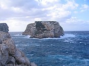
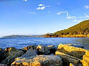
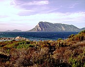
This list is of the Marine Protected Areas (Italian: aree marine protette) of Italy. As of the most recent Official list of natural protected areas [it], decreed on 27 April 2010 and published in the official gazette on 31 May 2010 by the Ministry for Environment, Land and Sea Protection, there were twenty-seven such marine protected areas, and a further two "Submerged Archaeological Parks" (Italian: parchi sommersi); in 2018, two new marine protected areas were created. Typically subdivided into Zones A, B, and C, each affording a different level of protection, these areas help safeguard in total some 228,000 hectares (2,280 km2) of the seas around Italy as well as some 700 kilometres (430 mi) of its coastline. The Ligurian Sea Cetacean Sanctuary is not included in these figures. [1] [2] [3] While some stakeholders have opposed such measures, fearing the impact on short-term economic exploitation, a study of the alternatives at Portofino suggested that steps at protection might offer not only environmental benefits but also the concomitant potential of enhanced long-term usufruct. [4]
| Name | Image | Region | Area (km2) | Coast (km) | Established | Coordinates | EUAP Code | Reference |
|---|---|---|---|---|---|---|---|---|
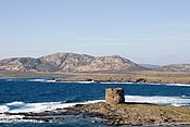
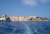
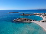
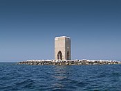
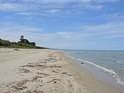
| Baia | 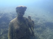 | Campania | 1.77 | 3.72 | 2002 | 40°49′19″N14°04′39″E / 40.8219°N 14.0774°E | EUAP0849 | |
| Gaiola |  | Campania | 0.41 | 1.99 | 2002 | 40°47′31″N14°11′13″E / 40.7919°N 14.1869°E | EUAP0850 | |

The geography of Malta is dominated by water. Malta is an archipelago of coralline limestone, located in Europe, in the Mediterranean Sea, 81 kilometres south of Sicily, Italy, and nearly 300 km north (Libya) and northeast (Tunisia) of Africa. Although Malta is situated in Southern Europe, it is located farther south than Tunis, capital of Tunisia, Algiers, capital of Algeria, Tangier in Morocco and also Aleppo in Syria, and Mosul in Iraq in the Middle East. Only the three largest islands – Malta, Gozo and Comino – are inhabited. Other (uninhabited) islands are: Cominotto, Filfla and the St.Paul's Islands. The country is approximately 316 km2 in area. Numerous bays along the indented coastline of the islands provide harbours. The landscape of the islands is characterised by high hills with terraced fields. The highest point, at 253 metres, Ta' Zuta on mainland Malta. The capital is Valletta.
Specially Protected Areas of Mediterranean Importance (SPAMI) are sites "of importance for conserving the components of biological diversity in the Mediterranean; contain ecosystems specific to the Mediterranean area or the habitats of endangered species; are of special interest at the scientific, aesthetic, cultural or educational levels".
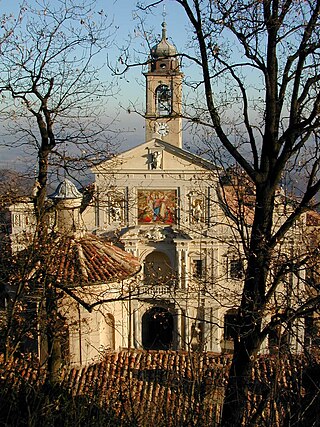
The Sacro Monte di Crea is a Roman Catholic sanctuary in the comune of Serralunga di Crea, Piedmont, northern Italy. It is reached via a steeply ascending route which winds through a wooded natural park, whose flora was catalogued by the Casalese photographer and polymath Francesco Negri.

Duxbury Reef State Marine Conservation Area (SMCA) is a marine protected area located about 1 mile (2 km) west of Bolinas in Marin County on California’s north central coast. This marine protected area covers 0.66 square miles (1.7 km2). Duxbury Reef SMCA prohibits the take of all living marine resources, except the recreational take of finfish from shore only and the recreational take of abalone.

The fauna of Italy comprises all the animal species inhabiting the territory of the Italian Republic and its surrounding waters. Italy has one of the highest levels of faunal biodiversity in Europe, with over 57,000 species recorded, representing more than a third of all European fauna. This is due to various factors. The Italian peninsula is in the centre of the Mediterranean Sea, forming a corridor between central Europe and North Africa, and it has 8,000 km (5,000 mi) of coastline. Italy also receives species from the Balkans, Eurasia, and the Middle East. Italy's varied geological structure, including the Alps and the Apennines, Central Italian woodlands, and Southern Italian Garigue and Maquis shrubland, also contribute to high climate and habitat diversity.

Cambria State Marine Conservation Area (SMCA) is a marine protected area located off the coast of the city of Cambria, California on California’s central coast in San Luis Obispo County, California. The marine protected area covers 6.26 square miles (16.2 km2). Within the SMCA recreational fishing and take is allowed while commercial fishing and take of all living marine resources is prohibited.

Soquel Canyon State Marine Conservation Area (SMCA) is an offshore marine protected area in Monterey Bay. Monterey Bay is on California’s central coast with the city of Monterey at its south end and the city of Santa Cruz at its north end. The SMCA covers 23.41 square miles (60.6 km2). Within the SMCA, fishing and taking of any living marine resources is prohibited except the commercial and recreational take of pelagic finfish.

The Natural Reserve Parma Morta is located in Emilia-Romagna in the commune of Mezzani, and was established in 1990.

The Riserva Naturale Pian di Spagna e Lago di Mezzola is a nature reserve in Lombardy, in northern Italy. The reserve consists of the Lago di Mezzola and the Pian di Spagna, the wetland area which separates it from Lake Como. It includes parts of the comuni of Sorico and Gera Lario in the province of Como, and of the comuni of Dubino, Verceia and Novate Mezzola in the province of Sondrio. It was established by Deliberazione del Consiglio Regionale III/1913, dated 6 February 1985, and has the EUAP reference code EUAP0326.

Wildlife Protection Areas in Japan are established by the Ministry of the Environment and, for areas of more local importance, by the Prefectural Governments in order "to protect and promote the reproduction of birds and mammals" in accordance with the 2002 Wildlife Protection and Hunting Law. The areas established have a maximum duration of twenty years and hunting is prohibited within them. Special Protection Areas (特別保護地区) are designated within the Wildlife Protection Areas in order to protect habitats and ecosystems.
A Regional Reserve is a type of protected area used in South Australia that allows the use of natural resources in conjunction with the protected area's conservation function. This class of protected area was first used in 1988 for the Innamincka Regional Reserve and as of 2015, there are seven regional reserves that cover an area of 93,400 square kilometres (36,062 sq mi) or 9.5% of South Australia's land area.
Natural Habitat Conservation Areas or Natural Habitat Protection Areas in Japan are designated by the Ministry of the Environment to protect species of flora and fauna designated National Endangered Species, in accordance with the 1992 Act on Conservation of Endangered Species of Wild Fauna and Flora. Both managed protection zones and buffer monitoring zones are established.

The Nature Reserve Bosco di Alcamo is a natural protected area of Regione Siciliana established in 1984, and located on the top of monte Bonifato, which dominates the town of Alcamo.
The Beigua Natural Regional Park is a natural park located in province of Savona and the Metropolitan City of Genoa, both in Liguria (Italy). It's the largest protected area of the region. It gets the name from the highest mountain of the area, Monte Beigua.
The Antola Natural Regional Park is a natural park in Metropolitan City of Genoa. It gets the name from the highest mountain of the area, Monte Antola.
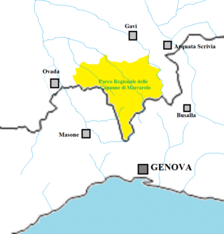
The Capanne di Marcarolo Natural Regional Park is a natural park in the province of Alessandria. It gets the name from a small village in the protected area, Capanne di Marcarolo.

Amami-Ōshima Island, Tokunoshima Island, northern part of Okinawa Island, and Iriomote Island (奄美大島、徳之島、沖縄島北部及び西表島) is a serial UNESCO World Heritage Site consisting of five component parts on four Japanese islands in the Ryukyu Chain of the Nansei Islands. The site was selected in terms of biodiversity for having a diverse ecosystem of plant and animal species that are unique to the region.