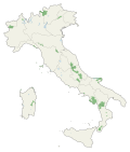
The national parks of Italy are protected natural areas terrestrial, marine, fluvial or lacustrine, which contain one or more intact ecosystems (or only partially altered by anthropic interventions) and/or one or more physical, geological, geomorphological, biological formations of national and international interest, for naturalistic, scientific, cultural, aesthetic, educational, or recreational values, such as to justify the intervention of the State for their conservation.
There are 25 Italian national parks registered on the Official List of Protected Natural Areas (EUAP), and they together cover an area of over 16,000 km2 (6,200 sq mi), which corresponds to approximately 5.3% of the Italian national territory. [1] The parks are managed by the Ministry of the Environment based in Rome (Italian : Ministero dell'Ambiente). [2]
Name | Regions | Area | High Point | Elevation | Established | Map | Quick View |
---|---|---|---|---|---|---|---|
Abruzzo, Lazio and Molise [3] | Abruzzo, Lazio, Molise | 506.83 km2 (195.69 sq mi) | Monte Petroso | 2,249 m (7,379 ft) | 1923 | ||
Circeo [4] | Lazio | 84.40 km2 (32.59 sq mi) | Monte Circeo | 541 m (1,775 ft) | 1934 | ||
Gran Paradiso [5] | Valle d'Aosta, Piedmont | 700.00 km2 (270.27 sq mi) | Gran Paradiso | 4,061 m (13,323 ft) | 1922 | ||
Stelvio [6] | Lombardy, Trentino-Alto Adige/Südtirol | 1,307.00 km2 (504.64 sq mi) | Cima Ortles | 3,905 m (12,812 ft) | 1935 |
Name | Regions | Area | High Point | Elevation | Established | Map | Quick View |
---|---|---|---|---|---|---|---|
Aspromonte [7] | Calabria | 760.53 km2 (293.64 sq mi) | Montalto | 1,955 m (6,414 ft) | 1989 | ||
Dolomiti Bellunesi [8] | Veneto | 31.51 km2 (12.17 sq mi) | Monte Pavione | 2,335 m (7,661 ft) | 1988 | ||
Foreste Casentinesi, Monte Falterona, and Campigna [9] | Emilia-Romagna, Tuscany | 364.00 km2 (140.54 sq mi) | Monte Falterona | 1,645 m (5,397 ft) | 1989 | ||
Pollino [10] | Basilicata, Calabria | 1,925.65 km2 (743.50 sq mi) | Sierra Dolcedorme | 2,267 m (7,438 ft) | 1988 |
Name | Regions | Area | High Point | Elevation | Established | Map | Quick View |
---|---|---|---|---|---|---|---|
Archipelago of La Maddalena [11] | Sardinia | 201.46 km2 (77.78 sq mi) | Punta Tejalone, Caprera [12] | 212 m (696 ft) | 1994 | ||
Asinara [13] | Sardinia | 269.60 km2 (104.09 sq mi) | Punta Scomunica | 408 m (1,339 ft) | 1997 | ||
Cilento, Vallo di Diano, and Alburni [14] | Campania | 1,810.48 km2 (699.03 sq mi) | Monte Cervati | 1,898 m (6,227 ft) | 1991 | ||
Cinque Terre [15] | Liguria | 38.60 km2 (14.90 sq mi) | Monte (Mai-)Pertuso [16] | 820 m (2,690 ft) | 1999 | ||
Gargano [17] | Apulia | 1,211.18 km2 (467.64 sq mi) | Monte Calvo [18] | 1,065 m (3,494 ft) | 1991 | ||
Gennargentu [19] | Sardinia | 730.00 km2 (281.85 sq mi) | Punta La Marmora | 1,834 m (6,017 ft) | 1998 | ||
Gran Sasso and Monti della Laga [20] | Marche, Abruzzo, Lazio | 1,413.31 km2 (545.68 sq mi) | Corno Grande | 2,912 m (9,554 ft) | 1991 | ||
Majella [21] | Abruzzo | 704.00 km2 (271.82 sq mi) | Monte Amaro | 2,793 m (9,163 ft) | 1991 | ||
Sibillini Mountains [22] | Marche, Umbria | 697.22 km2 (269.20 sq mi) | Monte Vettore | 2,476 m (8,123 ft) | 1988 | ||
Tuscan Archipelago [23] | Tuscany | 746.53 km2 (288.24 sq mi) | Monte Capanne on Elba in the Tuscan Archipelago | 1,018 m (3,340 ft) | 1989 | ||
Val Grande [24] | Piedmont | 145.98 km2 (56.36 sq mi) | Monte Togano | 2,295 m (7,530 ft) | 1991 | ||
Vesuvius [25] | Campania | 72.59 km2 (28.03 sq mi) | Great Cone | 1,281 m (4,203 ft) | 1991 |
Name | Regions | Area | High Point | Elevation | Established | Map | Quick View |
---|---|---|---|---|---|---|---|
Alta Murgia [26] | Apulia | 677.39 km2 (261.54 sq mi) | Torre Disperata | 686 m (2,251 ft) | 2004 | ||
Appennino Lucano - Val d'Agri - Lagonegrese [27] | Basilicata | 689.96 km2 (266.40 sq mi) | Monte del Papa | 2,005 m (6,578 ft) | 2007 | ||
Appennino Tosco-Emiliano [28] | Emilia-Romagna, Tuscany | 227.92 km2 (88.00 sq mi) | Monte Cusna | 2,121 m (6,959 ft) | 1997 | ||
Sila [29] | Calabria | 736.95 km2 (284.54 sq mi) | Monte Botte Donato | 1,928 m (6,325 ft) | 1997 |
Name | Regions | Area | High Point | Elevation | Established | Map | Quick View |
---|---|---|---|---|---|---|---|
Island of Pantelleria | Sicily | 66.4 km2 (25.6 sq mi) | Montagna Grande | 836 m (2,743 ft) | 2016 |
Gran Sasso d'Italia is a massif in the Apennine Mountains of Italy. Its highest peak, Corno Grande 2,912 metres (9,554 ft), is the highest mountain in the Apennines, and the second-highest mountain in Italy outside the Alps. The mountain lies within Gran Sasso e Monti della Laga National Park.
The province of Rieti is a province in the Lazio region of Italy. Its capital is the city of Rieti. Established in 1927, it has an area of 2,750.52 square kilometres (1,061.98 sq mi) with a total population of 157,887 people as of 2017. There are 73 comuni in the province.
Abruzzo, Lazio and Molise National Park is an Italian national park established in 1923. The majority of the park is located in the Abruzzo region, with smaller parts in Lazio and Molise. It is sometimes called by its former name Abruzzo National Park. The park headquarters are in Pescasseroli in the Province of L'Aquila. The park's area is 496.80 km2 (191.82 sq mi).
Val Camonica or Valcamonica, also Valle Camonica and anglicized as Camonica Valley, is one of the largest valleys of the central Alps, in eastern Lombardy, Italy. It extends about 90 kilometres (56 mi) from the Tonale Pass to Corna Trentapassi, in the commune of Pisogne near Lake Iseo. It has an area of about 1,335 km2 (515 sq mi) and 118,323 inhabitants. The River Oglio runs through its full length, rising at Ponte di Legno and flowing into Lake Iseo between Pisogne and Costa Volpino.
Cagnano Amiterno is a comune and town in the Province of L'Aquila in the Abruzzo region of central Italy.
Castel del Monte is a medieval and Renaissance hill town and comune in the province of L'Aquila in northern Abruzzo, Italy. Located in the heart of the Gran Sasso mountain range, the town is set into a steep hillside nestled beneath mountain peaks near the high plain of Campo Imperatore. Castel del Monte sits opposite the ancient mountaintop fortress of Rocca Calascio and faces Monte Sirente in the distance. It is located in the Gran Sasso e Monti della Laga National Park. It is one of I Borghi più belli d'Italia.
Brittoli is a comune and town in the province of Pescara in the Abruzzo region of Italy. It is located in the Gran Sasso e Monti della Laga National Park.
Castiglione a Casauria is a comune and town in the province of Pescara in the Abruzzo region of Italy. It is located in the natural park known as the "Gran Sasso e Monti della Laga National Park".
The Gran Sasso and Monti della Laga National Park is a natural park in central Italy. Established in 1991, it covers an area of 2,014 square kilometres (778 sq mi), mostly within the provinces of Teramo, L'Aquila, and Pescara in Abruzzo, with small areas in the provinces of Rieti in Lazio and Ascoli Piceno in Marche. The terrain is predominantly mountainous with alpine plains.
Cilento, Vallo di Diano and Alburni National Park is an Italian national park in the Province of Salerno, in Campania in southern Italy. It includes much of the Cilento, the Vallo di Diano and the Monti Alburni. It was founded in 1991 and was formerly known as the Parco Nazionale del Cilento e Vallo di Diano.
The Gargano National Park is a national park in the province of Foggia in southern Italy. Aside from the Gargano promontory from which it takes its name, it includes also the Tremiti Islands archipelago and the wetlands Lago Salso. It is the largest park in Apulia.
Lorenzo Arnone Sipari is an Italian nature writer and historian, author of many studies on the social and environmental history, especially on the origins and foundation of Parco Nazionale d'Abruzzo.
Tourism in Abruzzo has become one of the most prosperous sectors in the economy of Abruzzo, and in recent years has seen a remarkable growth attracting numerous tourists from Italy and Europe. According to statistics, in 2021 arrivals totaled 1,330,887. A total of 5,197,765 arrivals were tourists, a figure that puts the region seventeenth among the Italian regions for numbers of tourists per year. A moderate support to tourism is also given to the Abruzzo Airport with many low cost and charter flights connecting the entire region with the rest of Europe.
Val Grande National Park is a protected area located in Piedmont, in the north of Italy. It is most notable for landscapes of the High Alps.
The Beigua Natural Regional Park is a natural park located in province of Savona and the Metropolitan City of Genoa, both in Liguria (Italy). It's the largest protected area of the region. It gets the name from the highest mountain of the area, Monte Beigua.
The Antola Natural Regional Park is a natural park in Metropolitan City of Genoa. It gets the name from the highest mountain of the area, Monte Antola.
The Capanne di Marcarolo Natural Regional Park is a natural park in the province of Alessandria. It gets the name from a small village in the protected area, Capanne di Marcarolo.
The Dolomiti Bellunesi National Park is a national park in the province of Belluno, Veneto, in the northern Italy.
Assergi is a frazione of the comune of L'Aquila, located about 11 km (6.8 mi) from the capital. With a population of just over 500, it is situated at an altitude of approximately 1,000 meters, below the western slope of the Gran Sasso in a small plain called the Piana di Assergi (Plain of Assergi). Assergi was formerly included in the comune of Camarda, which is directly to its south.