
The province of Grosseto is a province in the Tuscany region of Italy. Its capital is the city of Grosseto. As of 2013 the province had a total population of 225,098 people.

Abruzzo is a region of Southern Italy with an area of 10,763 square km and a population of 1.3 million. It is divided into four provinces: L'Aquila, Teramo, Pescara, and Chieti. Its western border lies 80 km (50 mi) east of Rome. Abruzzo borders the region of Marche to the north, Lazio to the west and north-west, Molise to the south and the Adriatic Sea to the east. Geographically, Abruzzo is divided into a mountainous area in the west, which includes the highest massifs of the Apennines, such as the Gran Sasso d'Italia and the Maiella, and a coastal area in the east with beaches on the Adriatic Sea.

The Apennines or Apennine Mountains are a mountain range consisting of parallel smaller chains extending c. 1,200 km (750 mi) along the length of peninsular Italy. In the northwest they join with the Ligurian Alps at Altare. In the southwest they end at Reggio di Calabria, the coastal city at the tip of the peninsula. Since 2000 the Environment Ministry of Italy, following the recommendations of the Apennines Park of Europe Project, has been defining the Apennines System to include the mountains of north Sicily, for a total distance of 1,500 kilometres (930 mi). The system forms an arc enclosing the east side of the Ligurian and Tyrrhenian Seas.
Gran Sasso d'Italia is a massif in the Apennine Mountains of Italy. Its highest peak, Corno Grande, is the highest mountain in the Apennines, and the second-highest mountain in Italy outside the Alps. The mountain lies within Gran Sasso e Monti della Laga National Park.

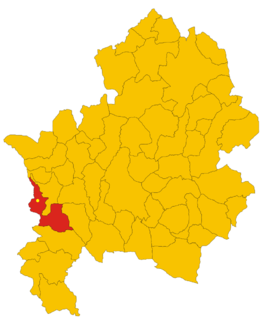
The Province of Rieti is a province in the Lazio region of Italy. Its capital is the city of Rieti. Established in 1927, it has an area of 2,750.52 square kilometres (1,061.98 sq mi) with a total population of 157,887 people as of 2017. There are 73 comuni in the province.
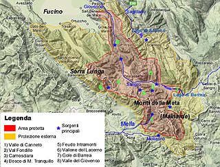
Abruzzo, Lazio and Molise National Park is an Italian national park established in 1923. The majority of the park is located in the Abruzzo region, with smaller parts in Lazio and Molise. It is sometimes called by its former name Abruzzo National Park. The park headquarters are in Pescasseroli in the Province of L'Aquila. The park's area is 496.80 km2 (191.82 sq mi).

Monti della Laga is a mountain range in the central Apennines of Italy. Their ruggedness and inaccessibility makes them one of the lesser known areas of the Italian peninsula.

The Gran Sasso and Monti della Laga National Park is a natural park located mostly in Abruzzo, Italy. It was established in 1991, it has an area of 2,014 square kilometres (778 sq mi), and it is mainly spread out across the province of Teramo, L'Aquila, Pescara, with small areas in the province of Rieti and Ascoli Piceno. The terrain is predominantly mountainous with alpine plains.
The Monti Simbruini are a mountain range in central Italy, a part of Apennines mountain system.

Marsica is a geographical and historical region in the Abruzzo, central Italy, including 37 comuni in the province of L'Aquila. It is located between the plain of the former Fucine Lake, the National Park of Abruzzo, Lazio and Molise, the plain of Carsoli and the valley of Sulmona.

The Maiella is a massif in the Central Apennines, in Abruzzo, central Italy.
Montagna dei Fiori is a mountain group in the Abruzzo, central Italy, forming the Monti Gemelli massif, together with the Montagna di Campli. It is located nearby the boundary between the province of Teramo and the Marche region; due to its proximity to Ascoli Piceno, it is also known as Montagna d'Ascoli.

Monte Gorzano is the highest peak in the Monti della Laga, in northern Abruzzo, central Italy. It has an elevation of 2,458 metres (8,064 ft) and is also the highest peak of Lazio. It is located on the boundary with the provinces of Teramo in the Abruzzo region and Rieti in the Lazio region. The source of the Tordino is near Monte Gorzano (Fiumata).
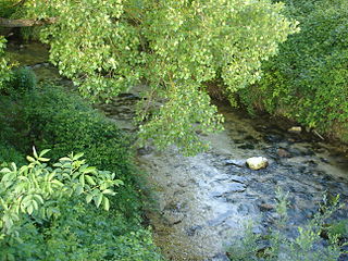
The Melfa is a river in Lazio, Italy. It rises in the Monti della Meta, flows south-west for about 40 kilometres (25 mi) and joins the Liri near San Giovanni Incarico.
Cerasuolo is an Italian village, the most populated hamlet (frazione) of Filignano, a municipality in the province of Isernia, Molise. As of 2009 its population was of 151.
The Monti Marsicani are the sixth-highest group of Apennines located in the Abruzzo region, mostly in the Province of L’Aquila and partly in the Province of Frosinone and Province of Isernia. The highest peak is Monte Greco (2285m). They are limited in north by the Fucino plateau and Peligna Valley, on the east by the River Gizio and Altopiano delle Cinque Miglia, on the south by the Valley Sangro and Volturno, on the east by valley Liri and Melfa.

Tourism in Abruzzo has become one of the most prosperous sectors in the economy of Abruzzo, and in recent years has seen a remarkable growth attracting numerous tourists from Italy and Europe. According to statistics from the Italian institute of statistics (ISTAT), in 2007 arrivals totaled 1,371,155 Italians and 189,651 foreigners. A total of 7,374,646 arrivals were tourists, a figure that puts the region seventeenth among the Italian regions for numbers of tourists per year. According to market analysis and sector studies on tourism in the Abruzzo National Society TurisMonitor 2012, after an increase that was estimated at between 4 and 5% of international tourist arrivals in the Abruzzo region in 2012 was estimated to increase that international arrivals will be around 3/4% by the end of 2012 with staff working in tourism will increase settling at about 25,000 people. Always position first-arrivals from Germany. A moderate support to tourism is also given to the Abruzzo Airport with many low cost and charter flights connecting the entire region with the rest of Europe.
The Monti delle Mainarde, also known just as Le Mainarde, is a range of calcareous mountains on the border between the regions of Lazio and Molise in southern central Italy. It is the southern extension of the Monti della Meta. The highest peak is Monte Cavallo, at 2039 m. Tributaries of the Melfa flow to the south-west from its western flanks, and tributaries of the Volturno to the south-east from its eastern side. Most of the range lies within the Parco Nazionale d'Abruzzo.
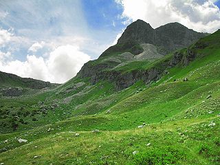
Monte Meta is a mountain of the Apennine Mountains, in central Italy.

