
The Apennines or Apennine Mountains are a mountain range consisting of parallel smaller chains extending c. 1,200 km (750 mi) along the length of peninsular Italy. In the northwest they join with the Ligurian Alps at Altare. In the southwest they end at Reggio di Calabria, the coastal city at the tip of the peninsula. Since 2000 the Environment Ministry of Italy, following the recommendations of the Apennines Park of Europe Project, has been defining the Apennines System to include the mountains of north Sicily, for a total distance of 1,500 kilometres (930 mi). The system forms an arc enclosing the east side of the Ligurian and Tyrrhenian seas.

The province of Teramo is a province in the Abruzzo region of Italy. Its capital is the city of Teramo. The province has an area of 1,948 square kilometres (752 sq mi), a population of 313,029 (2012), and is subdivided into 47 comuni, see comunes of the province of Teramo. The province of Teramo shares its northern border with the province of Ascoli Piceno in the Marche region, southern and southwestern borders with the province of L'Aquila in the Abruzzo region, and a western border with the province of Rieti in the Lazio region. To the south is the province of Pescara in the Abruzzo region and to the east is the Adriatic Sea.
The province of Frosinone is a province in the Lazio region of Italy. Its capital is the city of Frosinone. It has an area of 3,247 square kilometres (1,254 sq mi) and a total population of 493,605 (2016). The province contains 91 comuni, listed in the comuni of the province of Frosinone.

The province of Latina is a province in the Lazio region of Italy. Its provincial capital is the city of Latina. It is bordered by the provinces of Frosinone to the northeast and by the Metropolitan City of Rome Capital to the northwest.

The province of Rieti is a province in the Lazio region of Italy. Its capital is the city of Rieti. Established in 1927, it has an area of 2,750.52 square kilometres (1,061.98 sq mi) with a total population of 157,887 people as of 2017. There are 73 comuni in the province.
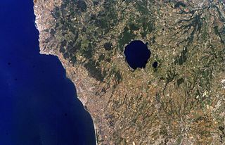
The Monti Sabatini is a geologic region in Lazio, central Italy, a remnant of intense volcanism which started ca. 600,000 years ago, mainly with pyroclastic and maar forming eruptions which continued until 100,000 years ago. The region is classified as a dormant volcanic district. The mountains are part of the Lazio's Anti-Apennines. Included between the Monti Sabatini is the Lake Bracciano, which is a volcanotectonic depression formed about 3.7 Ma, and the Lake Martignano. The sedimentary base of the Sabatini complex lies buried under 200 m (660 ft) of volcanic ash and rocks.

Latium adiectum or Latium Novum was a region of Roman Italy between Monte Circeo and the river Garigliano, south of and immediately adjacent to Old Latium, hence its name of attached Latium.

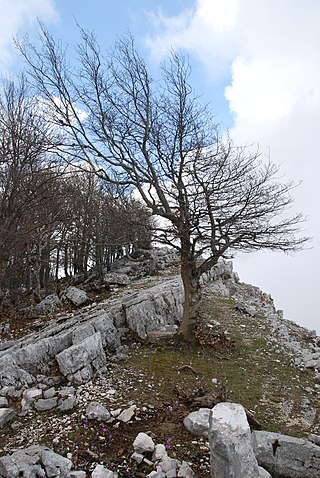
Monti della Laga is a mountain range in the central Apennines of Italy. Their ruggedness and inaccessibility makes them one of the lesser known areas of the Italian peninsula.

The Monti Aurunci is a mountain range of southern Lazio, in central Italy. It is part of the Antiappennini, a group running from the Apennines chain to the Tyrrhenian Sea, where it forms the promontory of Gaeta. It is bounded to the north-west by the Ausoni Mountains, to the north by the Liri river, to the east by the Ausente, to the south-east by the Garigliano and to the south by the Tyrrhenian sea. The line between the Aurunci and the Ausoni has not been clearly established but the Aurunci are considered by convention to be east of a line through Fondi, Lenola, Pico, S. Giovanni and Incarico. Altitudes vary from hills to the 1,533 m of Monte Petrella. Main peaks include the Redentore (1,252 m) and Monte Sant'Angelo (1,402 m). They include a regional park, the Parco Naturale dei Monti Aurunci, created in 1997.
The Monti Ernici are a mountain range in central Italy, part of the sub-Apennines of Lazio. They are bounded by the valley of the river Aniene to the north-east, that of the Liri to the east, and, from south to west, by the valleys of the Cosa and Sacco. They are the natural border between two central Italian regions, Lazio and Abruzzo.
The Sacco is a river of central Italy, a right tributary of the Liri. It flows between the Metropolitan City of Rome Capital and the province of Frosinone in Lazio.
The Monti Simbruini are a mountain range in central Italy, a part of Apennines mountain system.

The Monti della Tolfa are a volcanic group in the Anti-Apennines of the northern part of the Lazio region of Central Italy. They are bounded by the Tyrrhenian Sea coast to the west, by the Monti Sabatini to the east, and by the Monti Cimini and the Mignone river to the north. Tolfa and Allumiere are the principal towns.
The Monti Ausoni or Ausoni Mountains constitute a mountain range in southern Lazio, in central Italy. It is part of the Antiappennini, a group running from the Apennines chain to the Tyrrhenian Sea. They are bounded to the north by the Monti Lepini and to the south by the Monti Aurunci. They take the name from the ancient tribe of the Ausoni. The Monti Ausoni consist mainly of friable limestone. Altitudes vary from hills to the 1,152 m of Cima del Nibbio and the 1,141 m of Monte Calvo. Near Pastena are the Grotte di Pastena (caves).

The Monti Prenestini is a mountain range in the Lazio sub-Apennines, in central Italy to the east of Rome. It is of limestone formation. It is bounded by the Monti Tiburtini to the north, by the Monti Ruffi to the east, and by the valley of the river Sacco to the south. The highest peak is Monte Guadagnolo (1,218 m), in the comune of Capranica Prenestina.

Lake Fondi is a brackish lake about 90 km (56 mi) to the southeast of Rome in the Province of Latina, Lazio, Italy, in the region called Sud or "South" Pontino, the western end of which is the Piana di Fondi, "Plain of Fondi". The plain is a basin below the arc of the Monti Ausoni and the Monti Lepini. The lake forms naturally at the west end of the basin in a depression constantly filling with spring water exuding from the base of the mountains, which are a heavily cracked and faulted limestone karst absorbent of most rainfall. In addition to the flows from springs, a number of canals have been constructed from regions of the marsh below sea level to drain water from the marsh into the lake. Pumping stations are required to lift the water into the canals. Before the marsh was reclaimed the lake was part of it. Canals at either end of the lake connect it to the Tyrrhenian Sea.

The Apennine deciduous montane forests are a temperate broadleaf and mixed forests ecoregion in the Apennine Mountains of Italy. The development of these forests is ensured by the high rainfall in the Apennines, combined with a temperate-cool climate. Because of climate change, the presence of silver fir, although still widespread, has been dramatically reduced in favour of beech.
The Capestrina is an indigenous breed of domestic goat from the southern part of Lazio, in southern central Italy. It originates in the provinces of Frosinone, Latina and Rome, on the spines of the Monti Aurunci, the Monti Ausoni and the Monti Lepini. It is also raised in the Monti delle Mainarde and in the Val Comino, and on the Monti Prenestini. Its geographical range is similar to that of the Bianca Monticellana and the Ciociara Grigia; it is however usually found on higher and less accessible terrain than those breeds.
Monte Semprevisa is the highest peak in the Monti Lepini, in southern Lazio, central Italy. It has an elevation of 1,536 metres (5,039 ft).
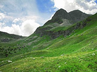
Monte Meta is a mountain of the Apennine Mountains, in central Italy.


