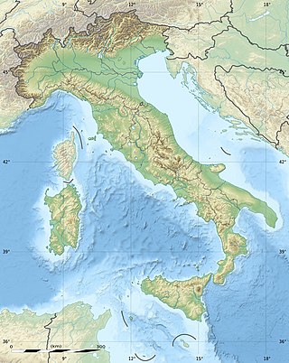
The geography of Italy includes the description of all the physical geographical elements of Italy. Italy, whose territory largely coincides with the homonymous geographical region, is located in southern Europe and comprises the long, boot-shaped Italian Peninsula crossed by the Apennines, the southern side of Alps, the large plain of the Po Valley and some islands including Sicily and Sardinia. Italy is part of the Northern Hemisphere. Two of the Pelagie Islands are located on the African continent.
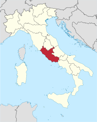
Lazio or Latium is one of the 20 administrative regions of Italy. Situated in the central peninsular section of the country, it has 5,714,882 inhabitants and a GDP of more than €212 billion per year, making it the country's second most populated region and second largest regional economy after Lombardy. The capital of Lazio is Rome, which is also the capital and largest city of Italy, and completely encircles Vatican City.

The Apennines or Apennine Mountains are a mountain range consisting of parallel smaller chains extending c. 1,200 km (750 mi) the length of peninsular Italy. In the northwest they join the Ligurian Alps at Altare. In the southwest they end at Reggio di Calabria, the coastal city at the tip of the peninsula. Since 2000 the Environment Ministry of Italy, following the recommendations of the Apennines Park of Europe Project, has defined the Apennines System to include the mountains of north Sicily, a total distance of 1,500 kilometres (930 mi). The system forms an arc enclosing the east of the Ligurian and Tyrrhenian seas.
The province of Frosinone is a province in the Lazio region of Italy. Its capital is the city of Frosinone. It has an area of 3,247 square kilometres (1,254 sq mi) and a total population of 493,605 (2016). The province contains 91 comuni, listed in the comuni of the province of Frosinone.

The province of Rieti is a province in the Lazio region of Italy. Its capital is the city of Rieti. Established in 1927, it has an area of 2,750.52 square kilometres (1,061.98 sq mi) with a total population of 157,887 people as of 2017. There are 73 comuni in the province.

The Pontine Marshes is an approximately quadrangular area of former marshland in the Lazio Region of central Italy, extending along the coast southeast of Rome about 45 km (28 mi) from just east of Anzio to Terracina, varying in distance inland between the Tyrrhenian Sea and the Volscian Mountains from 15 to 25 km. The northwestern border runs approximately from the mouth of the river Astura along the river and from its upper reaches to Cori in the Monti Lepini.

Latium Adjectum or Adiectum or Latium Novum was a region of Roman Italy between Monte Circeo and the river Garigliano, south of and immediately adjacent to Old Latium and included with it under the Roman Empire.

Monti della Laga is a mountain range in the central Apennines of Italy. Their ruggedness and inaccessibility makes them one of the lesser known areas of the Italian peninsula.

Monte San Giovanni in Sabina is a comune (municipality) in the Province of Rieti in the Italian region of Latium, located about 50 kilometres (31 mi) northeast of Rome and about 10 kilometres (6 mi) southwest of Rieti.

Torri in Sabina is a comune (municipality) in the Province of Rieti in the Italian region of Latium, located about 50 kilometres (31 mi) north of Rome and about 20 kilometres (12 mi) southwest of Rieti. Located on a ridge of the Monti Sabini, it is part of the Sabina traditional region.

The Monti Aurunci is a mountain range of southern Lazio, in central Italy. It is part of the Antiappennini, a group running from the Apennines chain to the Tyrrhenian Sea, where it forms the promontory of Gaeta. It is bounded to the north-west by the Ausoni Mountains, to the north by the Liri river, to the east by the Ausente, to the south-east by the Garigliano and to the south by the Tyrrhenian sea. The line between the Aurunci and the Ausoni has not been clearly established but the Aurunci are considered by convention to be east of a line through Fondi, Lenola, Pico, S. Giovanni and Incarico. Altitudes vary from hills to the 1,533 m of Monte Petrella. Main peaks include the Redentore (1,252 m) and Monte Sant'Angelo (1,402 m). They include a regional park, the Parco Naturale dei Monti Aurunci, created in 1997.

The Sibillini Mountains, or Sibylline Mountains are one of the major mountain groups in the Italian Peninsula, and part of the Apennines range. Most of the peaks are over 2,000 m (6,600 ft); the highest is Monte Vettore at 2,476 m (8,123 ft).
The Monti Ernici are a mountain range in central Italy, part of the sub-Apennines of Lazio. They are bounded by the valley of the river Aniene to the north-east, that of the Liri to the east, and, from south to west, by the valleys of the Cosa and Sacco. They are the natural border between two central Italian regions, Lazio and Abruzzo.

The Monti Lepini are a mountain range which belongs to the Anti-Apennines of the Lazio region of central Italy, between the two provinces of Latina and Rome.
The Monti Simbruini are a mountain range in central Italy, a part of Apennines mountain system.

The Monti Picentini is a mountain range and national park in southern Italy, part of the Apennines, traditionally part in the Campanian Apennines. They are included between the Monti Lattari, the Partenio mount, the Irpinian plateau and the Sele river valley. The chain is included in the Monti Picentini Regional Park.
The Monti Ausoni or Ausoni Mountains constitute a mountain range in southern Lazio, in central Italy. It is part of the Antiappennini, a group running from the Apennines chain to the Tyrrhenian Sea. They are bounded to the north by the Monti Lepini and to the south by the Monti Aurunci. They take the name from the ancient tribe of the Ausoni. The Monti Ausoni consist mainly of friable limestone. Altitudes vary from hills to the 1,152 m of Cima del Nibbio and the 1,141 m of Monte Calvo. Near Pastena are the Grotte di Pastena (caves).

The Monti Prenestini is a mountain range in the Lazio sub-Apennines, in central Italy to the east of Rome. It is of limestone formation. It is bounded by the Monti Tiburtini to the north, by the Monti Ruffi to the east, and by the valley of the river Sacco to the south. The highest peak is Monte Guadagnolo (1,218 m), in the comune of Capranica Prenestina.

The Maiella (or Majella) is a massif in the Central Apennines, in Abruzzo, central Italy.
Monte Cairo (1,669 m) is a mountain in Lazio, overshadowing both the Abbey and the town of Monte Cassino, 5 kilometres to the south. The ancient 'Mons Clarius' was so called because originally a temple dedicated to Apollo (Clarius) stood where the Abbey of Monte Cassino now stands. The Monte Cairo is the main peak of an isolated mountain range that extends eastwards for about 16–18 km from the Alta Valle del Melfa, the road from Rome to Naples.

