| Parco Nazionale dell'Alta Murgia | |
|---|---|
 Poggiorsini dale in Alta Murgia National Park | |
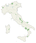
 Alta Murgia Location of Alta Murgia National Park | |
| Location | |
| Nearest city | Bari |
| Coordinates | 40°59′24″N16°22′12″E / 40.99000°N 16.37000°E |
| Area | 677.39 km2 (261.54 sq mi) |
| Established | 2004 |
| Governing body | Ministero dell'Ambiente |
| www | |
The Parco Nazionale dell'Alta Murgia is a national park in Apulia, southern Italy, established in 2004. It lies in the Murgia geographical area, with its headquarters in the town of Gravina in Puglia, and has an area of 677.39 square kilometres. It is part of a larger Special Protection Area established to protect the grass steppe, lesser kestrel's habitat (Site of Community Importance).