
The Gran Paradiso or Grand Paradis is a mountain in the Graian Alps in Italy, located between the Aosta Valley and Piedmont regions.
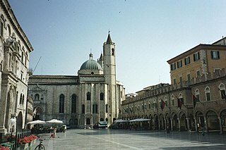
Ascoli Piceno is a town and comune in the Marche region of Italy, capital of the province of the same name. Its population is around 48,278 but the urban area of the city has more than 93,000.
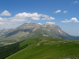
Monte Vettore is a mountain of the Apennines. It is the highest peak of the Sibillini massif.
The Province of Rieti is a province in the Lazio region of Italy. Its capital is the city of Rieti. Established in 1927, it has an area of 2,750.52 square kilometres (1,061.98 sq mi) with a total population of 157,887 people as of 2017. There are 73 comuni in the province.
Parco Nazionale d'Abruzzo, Lazio e Molise is an Italian national park founded in 1922. The majority of the park is located in the Abruzzo region though it is not constrained by regional boundaries and also includes territory in Lazio and Molise. The park headquarters are in Pescasseroli in the Province of L'Aquila. The park currently includes 496.80 km2 (191.82 sq mi).

Padula is a small village in the Province of Teramo, in the Abruzzo region of central Italy. It is a hamlet (frazione) of the commune of Cortino.

Amandola is a comune (municipality) in the Province of Fermo in the Italian region Marche, located about 70 kilometres (43 mi) south of Ancona, about 25 kilometres (16 mi) northwest of Ascoli Piceno and about 35 kilometres (22 mi) west of Fermo. The town was founded in 1248 by the union of the castles of Agello Leone and Marrubbione, which formed a free municipality.

The Sibillini Mountains, or Sibylline Mountains are one of the major mountain groups of italic peninsula, part of Apennines mountain range. Most of the peaks are over 2,000 m (6,600 ft); the highest altitude is reached by Monte Vettore at 2,476 m (8,123 ft).

Pollino National Park is a national park in southern Italy that straddles the regions of Basilicata and Calabria. It is Italy's largest national park, covering 1,925.65 square kilometers.

The Parco Nazionale del Cilento, Vallo di Diano e Alburni is an Italian national park in the Province of Salerno, in Campania in southern Italy. It includes much of the Cilento, the Vallo di Diano and the Monti Alburni. It was founded in 1991, and was formerly known as the Parco Nazionale del Cilento e Vallo di Diano.

Monte Frontè is a mountain in Liguria, northern Italy, part of the Alps. It is located in the province of province of Imperia. It lies at an altitude of 2,152 metres. After Monte Saccarello it is the second highest peak in the Ligurian region.

Monte Reixa is a mountain in Liguria, northern Italy, part of the Ligurian Appennines.
The Sopravissana is a breed of domestic sheep from the province of Macerata, in the Marche in central Italy. The name derives from the area of origin, the comune of Visso in the Monti Sibillini; it was traditionally raised mostly in that area, but flocks ranged into Lazio, Tuscany and Umbria. The Sopravissana derives from the cross-breeding of local ewes with Spanish and Rambouillet Merino rams in the 18th century. It is larger than the Vissana breed from the same area.

The Alta Via dei Monti Liguri (AV) is a long-distance waymarked hiking trail in the Italian region of Liguria. In about 440 kilometres (270 mi) and 44 day hikes, it runs through the arc formed by Ligurian Alps and Ligurian Apennines from Ventimiglia to Ceparana.

The Beigua Natural Regional Park is a natural park located in province of Savona and the Metropolitan City of Genoa, both in Liguria (Italy). It's the largest protected area of the region. It gets the name from the highest mountain of the area, Monte Beigua.
Sant'Agostino is a Roman Catholic church and former monastery located in the town limits of San Ginesio, province of Macerata, in the region of Marche, Italy. The complex for some years included an elementary school, and the church is presently a civic auditorium.
The Abbazia di Santa Maria delle Macchie was a Roman Catholic Benedictine monastery in a rural hamlet of Macchie, a few kilometers from the town of San Ginesio, in the province of Macerata, region of Marche, Italy.
The Chiesa della Madonna del Vallone is a Roman Catholic church or sanctuary located in a rural site in the frazione of Piedicolle in Acquacanina, province of Macerata, in the region of Marche, Italy. It is located within the Parco Nazionale dei Monti Sibillini.


