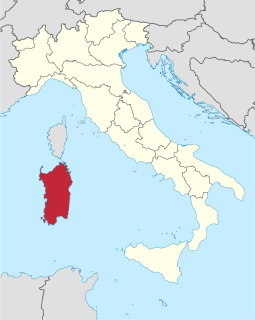
Sardinia is an island in the Mediterranean Sea and politically one of the 20 regions of Italy. It is the second-largest island in the Mediterranean Sea after Sicily, and is located west of the Italian Peninsula, north of Tunisia, and to the immediate south of the French island of Corsica.

Gallura is a region in North-Eastern Sardinia (Italy).
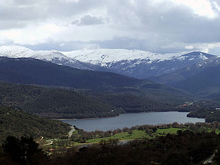
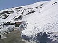
Gennargentu is a large massif in central-southern Sardinia, Italy, encompassing the provinces of Nuoro and Ogliastra. It includes the highest peaks on the island, such as Punta La Marmora, Monte Spada, Punta Erba Irdes, Bruncu Spina and Punta Paulinu.

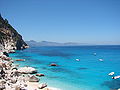
Cala Gonone is an Italian seaside town and a civil parish (frazione) of the municipality (comune) of Dorgali, Province of Nuoro, in the region of Sardinia. In 2007 it had 1,279 inhabitants.

The Province of Nuoro is a province in the autonomous island region of Sardinia, Italy. Its capital is the city of Nuoro.

The Tuscan Archipelago is a chain of islands between the Ligurian Sea and Tyrrhenian Sea, west of Tuscany, Italy.

Asinara is an Italian island of 52 km2 (20 sq mi) in area. The name is Italian for "donkey-inhabited", but it is thought to derive from the Latin "sinuaria", and meaning sinus-shaped. The island is virtually uninhabited. The census of population of 2001 lists one man. The island is located off the north-western tip of Sardinia, and is mountainous in geography with steep, rocky coasts. Because fresh water is scarce, trees are sparse and low scrub is the predominant vegetation. Part of the national parks system of Italy, the island was recently converted to a wildlife and marine preserve. It is home to a population of wild Albino donkeys from which the island may take its name.

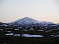
Mount Ortobene is a mountain in the province of Nuoro, in central Sardinia, Italy, close to the town of Nuoro.
Dorgali is a comune (municipality) in the Province of Nuoro in the Italian region Sardinia, located about 230 kilometres (140 mi) northeast of Cagliari and about 38 kilometres (24 mi) east of Nuoro in the Seaside Supramonte mountain area.
Tiana, Tìana in sardinian language, is a comune (municipality) in the Province of Nuoro in the Italian region Sardinia, located in a valley on the slopes of Gennargentu mountain in the Ollolai Barbagia, about 150 kilometres (93 mi) north of Cagliari and about 50 kilometres (31 mi) southwest of Nuoro. As of 31 December 2004, it had a population of 547 and an area of 19.3 square kilometres (7.5 sq mi).

Arbus is a comune (municipality) in the Province of South Sardinia in the Italian region of Sardinia. Located in the southwest coast of the island, Arbus is known for its coastline, the Costa Verde, and for several archeological sites, such as the mines of Montevecchio. With an area of 267 square kilometres, Arbus is the second largest municipality in Sardinia.

Villasimius, Crabonaxa in Sardinian language, is a comune (municipality) in the Province of South Sardinia in the Italian region Sardinia, located about 35 kilometres (22 mi) east of Cagliari.
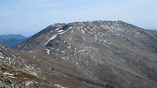
Punta La Marmora is a mountain in the Gennargentu range, Sardinia ( Italy).

The Supramonte is a mountain range located in central-eastern Sardinia, Italy. It lies northeast of the Gennargentu massif, traveling eastwards until it reaches the Tyrrhenian Sea at the Gulf of Orosei. It has an area of about 35,000 hectares, encompassing most of the territories of the comuni (municipalities) of Baunei, Dorgali, Oliena, Orgosolo and Urzulei. The populated areas of these comuni lie at the borders of the Supramonte, which, for the most part, is a largely uninhabited area of sharp limestone cliffs and deep, lush canyons.

The Nuragic civilization, also known as the Nuragic culture was a civilization or culture on the island of Sardinia, Italy, the second largest island in the Mediterranean Sea, which lasted from the 18th century BC to 238 BC when the Romans colonized the island. Others date the culture as lasting at least until the 2nd century or possibly even to the 6th century.

The Sardinians, or Sards, are a Romance ethnic group native to Sardinia, from which the western Mediterranean island and autonomous region of Italy derives its name.

The Metropolitan City of Cagliari is a metropolitan city in Sardinia, Italy. Its capital is the city of Cagliari and includes 17 comuni. It was established by law in 2016 and replaced the Province of Cagliari. The current president is the mayor of Cagliari, Paolo Truzzu. The resident population is approximately 432,000. This figure can rise due to commuting into the functional urban area to approximately 477,000
Sardinia is the second largest island in the Mediterranean Sea and an autonomous region of Italy. Tourism in Sardinia is one of the fastest growing sectors of the regional economy. The island attracts more than a million tourists from both Italy, from the rest of Europe, and, to a lesser degree, from the rest of the world. According to statistics, tourist arrivals in 2016 were 2.9 million people.

The Alpi Liguri Natural Regional Park is a natural park in Province of Imperia. It was established in 2007 by the legge regionale nr.34 of 15/11/2007.