List of national parks of Kazakhstan

Last updated
#NamePhotoLocationKazakhArea (km2)YearDescription
1 Altyn-Emel
Altynemel dune.jpg
Almaty Region
44°20′N78°26′E / 44.333°N 78.433°E / 44.333; 78.433
Relief Map of Kazakhstan.png
Red pog.svg
46001996The park covers about 4600 square kilometers between the Ili River and the Ak-Tau mountain range, near Lake Kapchagai, and consists mostly of desert and rocky terrain. [1]
2 Bayanaul
Mount Bulka.jpg
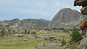
Pavlodar Province
50°49′N75°40′E / 50.817°N 75.667°E / 50.817; 75.667
Relief Map of Kazakhstan.png
Red pog.svg
6841985located in southeastern Pavlodar Province, 140 kilometers from the industrially developed city of Ekibastuz, on the outskirts of the Central Kazakh Uplands. The park was founded in 1985, making it Kazakhstan's first national park. It was created to preserve and restore the natural flora and fauna found in the Bayanaul mountain range.
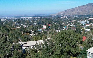
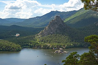
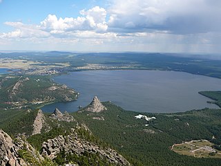
3 Burabay
Burabai.jpg
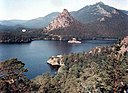
Akmola Region
53°05′N70°18′E / 53.083°N 70.300°E / 53.083; 70.300
Relief Map of Kazakhstan.png
Red pog.svg
8352000Burabay covers a tract of low mountains and pine forests on the Kokshetau steppe of north-central Kazakhstan. The park combines resort facilities, ecotourism, and nature conservation. [2]
4 Buiratau Akmola Region
51°20′N73°20′E / 51.333°N 73.333°E / 51.333; 73.333
Relief Map of Kazakhstan.png
Red pog.svg
8902011Preserves a unique transitional zone between dry steppe and semi-arid forest ecosystems of the Central Uplands of Kazakhstan. [3]
5 Charyn Canyon
Charyn Canyon - 3.jpg
Almaty Region
43°21′N79°04′E / 43.350°N 79.067°E / 43.350; 79.067
Relief Map of Kazakhstan.png
Red pog.svg
12512004The park stretches along the Charyn River, including Charyn Canyon. The Canyon, with its thinly stratified red sedimentary rock, it is said to resemble the Grand Canyon in the US; it is however smaller - 50 km from end to end. [4]
6 Ile-Alatau
Big Almaty Lake (Bolshaya Almatinka) in June.jpg
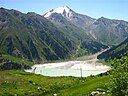
Almaty Region
43°05′N77°5′E / 43.083°N 77.083°E / 43.083; 77.083
Relief Map of Kazakhstan.png
Red pog.svg
20001996It is situated in the Zailiysky Alatau (“raised mountains”), south of the city of Almaty between Gorge Turgen in the east and Chemolgan River in the west. [5]
7 Karkaraly
Karkaraly, Karkaraly National Park, Kazakhstan.jpg
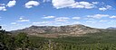
Karaganda Region
49°25′N75°25′E / 49.417°N 75.417°E / 49.417; 75.417
Relief Map of Kazakhstan.png
Red pog.svg
11211998Covers a pine-forested 'mountain oasis' in the steppes of the Kazakh Uplands. [6]
8 Katon-Karagay
Kazakhstan Altay.jpg
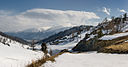
East Kazakhstan Region
49°10′N85°36′E / 49.167°N 85.600°E / 49.167; 85.600
Relief Map of Kazakhstan.png
Red pog.svg
64342001The park fills the west side of the "X" where the borders of Kazakhstan, Russia, China, and Mongolia meet. The highest peak in Siberia (Belukha Mountain, 4,506 m (14,783 ft)), is on the Russian border in the Katun Range. [7]
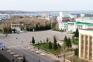
9 Kokshetau
Zerendinskie sopki.jpg
Akmola Region
53°15′N68°26′E / 53.250°N 68.433°E / 53.250; 68.433
Relief Map of Kazakhstan.png
Red pog.svg
18201996Located in the transition zone between the Siberian taiga (to the north) and the southern steppes, the terrain is an "island" of forests, lakes, and mountains surrounded by steppe.
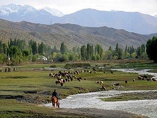
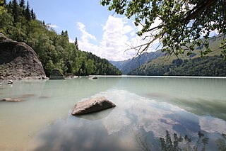
10 Kolsay Lakes
Kolsay Lake.jpeg
Almaty Region
42°56′N78°24′E / 42.933°N 78.400°E / 42.933; 78.400
Relief Map of Kazakhstan.png
Red pog.svg
16192007located on the north slope of the Tian Shan Mountains, southeast Kazakhstan (10 km from the border with Kyrgyzstan). Often referred to as "Pearls of Tien Shan", the park's main feature are the Kolsay Lakes located between the Raiymbek District and Talgar District of Almaty Region. The scenic Lake Kaindy is also within the park.
11 Sayram-Ugam
Reka Ugam vyshe leskhoza - panoramio.jpg
South Kazakhstan Region
41°57′N70°03′E / 41.950°N 70.050°E / 41.950; 70.050
Relief Map of Kazakhstan.png
Red pog.svg
14902007The park is a mountainous region of the Western Tian Shan Mountains, on the border with Uzbekistan. Ugam-Chatkal National Park of Uzbekistan is across the border, and Aksu-Zhabagly Nature Reserve of Kazakhstan is directly to the northeast along the border. It is particularly known for stands of juniper forests, and stands of fruit and nut trees. [8]
12 Tarbagatai
Urzhar.JPG
East Kazakhstan Region
47°17′N81°50′E / 47.283°N 81.833°E / 47.283; 81.833
Relief Map of Kazakhstan.png
Red pog.svg
13632018Tarbagatai was established in 2018 to protect a region of mountain-steppe in East Kazakhstan that supports stands of wild fruit trees that have been isolated from genetic encroachment by commercial varieties. [9]
13 Zhongar-Alatau
Malus sieversii in Zhongar-Alatau NP-1.jpg
Almaty Region
45°0′N80°0′E / 45.000°N 80.000°E / 45.000; 80.000
Relief Map of Kazakhstan.png
Red pog.svg
35602010Also known as Jungar Alatau, or Dzungurian Alatau, the park was created in 2010 to protect the unique ecology of the Dzungarian Alatau, an isolated, glaciated mountain range in Kazakhstan, on the southeastern border with China. [10]

Related Research Articles

<span class="mw-page-title-main">Almaty</span> Largest city in Kazakhstan

Almaty is the largest city in Kazakhstan, with a population of about 2 million. It was the capital of Kazakhstan from 1929 to 1936 as a autonomous republic within the Russian Soviet Federative Socialist Republic as part of the Soviet Union, then from 1936 to 1991 as a union republic and finally from 1991 as an independent state to 1997 when the government relocated the capital to Akmola.

<span class="mw-page-title-main">Kokshetau</span> City in Akmola Region, Kazakhstan

Kokshetau is a city in northern Kazakhstan and the capital of Akmola Region, which stretches along the southern shore of Lake Kopa, lying in the north of Kokshetau Uplands and the southern edge of the Ishim Steppe. It is named after the Mount Kokshe. Earlier, it was the administrative center of Kokshetau Region, which was abolished in 1997. It is also situated at the junction of the Trans-Kazakhstan and South Siberian railways. Kokshetau lies at an elevation of approximately 234 m (768 ft) above sea level.

Issyk-Kul Region Region of Kyrgyzstan

Issyk-Kul Region is one of the regions of Kyrgyzstan. Its capital is Karakol. It is surrounded by Almaty Region, Kazakhstan (north), Chüy Region (west), Naryn Region (southwest) and Xinjiang, China (southeast). It takes its name from Lake Issyk-Kul, the world's second-largest high altitude lake. Its total area is 43,735 km2 (16,886 sq mi). The resident population of the region was 501,933 as of January 2021. The region has a sizeable Russian minority.

Almaty Region Region of Kazakhstan

Almaty Region is a region of Kazakhstan, located in the southeastern part of the country. Its capital, from 1997 to 2022 was the city of Taldykorgan. But with the creation of the new Jetisu Region in 2022, Taldykorgan was chosen to be its capital and the capital of Almaty region was moved to the city of Konaev.

Talgar Town in Almaty Region, Kazakhstan

Talgar is a town in Almaty Region, southeastern Kazakhstan. It is the administrative center of Talgar District. The town is located between Almaty and Esik, 25 km from Almaty and several kilometres east of Birlik. Population: 45,529 ; 43,353.

Kokshetau Airport International airport serving Kokshetau, Kazakhstan

Kokshetau International Airport is an international airport in Akmola Region, Kazakhstan. It is the primary international airport serving Kokshetau, and also the nearest to the Burabay National Park and Kokshetau National Park. Opened in 1945, it is the seventeenth-busiest airport in terms of passenger traffic in Kazakhstan, with 21,683 passengers in calendar year 2019. The airport is located 12.5 km (7.8 mi) north-east from the centre of Kokshetau, the capital of Akmola Region in the northern part of Kazakhstan.

Charyn River in Kazakhstan

The Charyn is a river in the Almaty Province of Kazakhstan. It flows through the Charyn National Park and merges into the Ili River, which is considered to be the largest artery of Lake Balkhash. The Charyn is 427 kilometres (265 mi) long, and has a drainage basin of 7,720 square kilometres (2,980 sq mi). It runs through the territory of Kegen and Uighur regions, forming the Charyn Canyon.

Ile-Alatau National Park

Ile-Alatau National Park is a national park in Kazakhstan. It was created in 1996 and covers about 200,000 ha. It is situated in the mountains south of Almaty between Gorge Turgen in the east and Chemolgan River in the west. The National Park borders Almaty Nature Reserve, which is located around Pik Talgar.

Akmola Region Region of Kazakhstan

Akmola Region is a centrally located region of Kazakhstan. Its capital is Kokshetau. The national capital, Nur-Sultan, is enclosed by the region, but is politically separate from Akmola Region. The region's population is 715,000; Kokshetau's is 157,000.

Burabay National Park National park in Kazakhstan

The Burabay National Park is a natural park located in Burabay District, in Aqmola Region, Kazakhstan, near Nur-Sultan.

Lake Burabay Body of water

Burabay is one prominent lake of a group of lakes that share the same name in northern Kazakhstan, located in the Burabay District of Akmola Region, in the eastern foothills of Mount Kokshe.

Big Almaty Lake Body of water

Big Almaty Lake is natural alpine reservoir. It is located in the Trans-Ili Alatau mountains, 15 km south from the center of Almaty in Kazakhstan. The lake is 2511 meters above sea level.

Buiratau National Park or Buyratau National Nature Park was created in 2011 to preserve a unique transitional zone between dry steppe and semi-arid forest ecosystems of the Central Uplands of Kazakhstan. The park straddles the border of Ereymentau District of Akmola Region, and Osakarov District of Karaganda Region, and is about 60 km east of the capital city of Astana.

Kolsay Lakes National Park

Kolsay Lakes National Park is located on the north slope of the Tian Shan Mountains, southeast Kazakhstan. Often referred to as "Pearls of Tien Shan", the park's main feature are the Kolsay Lakes located between the Raiymbek District and Talgar District of Almaty Region. The scenic Lake Kaindy is also within the park. The park boundary is 120 kilometres (75 mi) southeast of Almaty. Lakes of landslide-tectonic origin, approximately formed in 1887 and 1911 on the Kaindy and Kolsay rivers.

Sayram-Ugam National Park

Sayram-Ugam National Park, also Sairam-Ugam, is a mountainous region of the Western Tian Shan Mountains, on the border with Uzbekistan. Ugam-Chatkal National Park of Uzbekistan is across the border, and Aksu-Zhabagly Nature Reserve of Kazakhstan is directly to the northeast along the border. The area has high levels of species diversity, covering floral communities from steppe to high altitude zones. It is particularly known for stands of juniper forests, and stands of fruit and nut trees. Sayram-Ugam is located in Kazygurt District, Tole Bi District and Tulkibas District of South Kazakhstan Region. The park boundary is 30 kilometres (19 mi) southeast of the regional city of Shymkent, and 50 km northeast of the Uzbekh capital of Tashkent.

Zhongar-Alatau National Park

Zhongar-Alatau National Park, also Jungar Alatau, or Dzungurian Alatau, was created in 2010 to protect the unique ecology of the Dzungarian Alatau, an isolated, glaciated mountain range in Kazakhstan, on the southeastern border with China. One stated reason for creating the park is to protect forests of wild fruit trees, including apricots, barberry, cherries, and currants. Approximately 1% of the land area of the park is forested with Sievers Apple trees, which are the progenitors of all cultured apple varieties in the world. The park is 300 km long (west-to-east), and spreads across Aksu District, Sarkand District and Alakol District of Almaty Region, 300 km northeast of the regional city of Almaty.

Kok Zhailau is a plateau in the territory of the Ile-Alatau State National Natural Park located at an altitude of 2251.2 m. It is located between the Small and Big Almaty gorges, 10 km from the city of Almaty. The plateau is located 1450-1740 m above sea level. Almaty, ski resort Shymbulak, Medeu and Big Almaty peak can be seen from the plateau.

The Mynjylky Mountain Plateau is a plateau in an elevated plain in the Almaty Region of Kazakhstan.

<span class="mw-page-title-main">Zhasylkol Lake</span> Lake in Kazakhstan

Zhasylkol Lake is a lake in Kazakhstan. It is on the Northern slope of the Dzungarian Alatau ridge.

References

  1. Altyn-Emel National Park Bird Life International
  2. "Park Burabay". Official Website - Park Burabay. Retrieved April 22, 2020.
  3. "Buiratau Park". Official web site, Buiratau State National Natural Park. Retrieved April 22, 2020.
  4. "Charyn Canyon NNP" . Retrieved April 18, 2020.
  5. "Ile Alatau National Park". Explore Kazakhstan. Retrieved April 22, 2020.
  6. "Astana Calling" (PDF). Ministry of Foreign Affairs of the Republic of Kazakhstan. Archived from the original (PDF) on December 31, 2010. Retrieved April 22, 2020.
  7. "Katon-Karagay". UNESCO. Retrieved April 22, 2020.
  8. "Sayram-Ugam National Park". Official Park Website. Retrieved April 22, 2020.
  9. "ORDER OF THE GOVERNMENT OF THE REPUBLIC OF KAZAKHSTAN - State national Tarbagatai natural park". CIS Legislation. Retrieved October 10, 2018.
  10. "Zhongar-Alatau National Park". Travel Around the World. UNDP. Retrieved 28 June 2017.

See also