List of national parks of Spain

Last updated

Map showing the distribution of the national parks in Spain as of 2021. Parques nacionales Espana.png
Map showing the distribution of the national parks in Spain as of 2021.

There are sixteen national parks in Spain: eleven in the Iberian Peninsula, four in the Canary Islands and one in the Balearic Islands. Twelve of the seventeen autonomous communities of Spain have national parks. Canary Islands has the most with four, followed by Andalusia with three, and Castile-La Mancha and Castile and León with two each. There are five autonomous communities that have no national parks: Basque Country, La Rioja, Murcia, Navarre, Valencian Community.

Contents

As of 2017 about 15 million people visited Spain's national parks, with Teide accounting for about 28% of all visitors. The second most visited park was Picos de Europa (17%), followed by Ordesa y Monte Perdido (13%). The least visited parks were Cabrera Archipelago (0.81%) and Cabañeros (0.72%). [1] With more than 2.5 million visitors in 2013, Teide was the most visited national park in Europe that year, and sixth most visited in the world. [2]

National parks

NamePhotoProvinceAutonomous communityDesignatedAreaDescriptionRef
Aigüestortes i Estany de Sant Maurici San Mauricio lake.jpg Lleida Catalonia 195514,119 ha
(34,889 acres)
Consists of two valleys (Sant Nicolau and L'Escrita) located between the rivers Noguera Pallaresa and Noguera Ribagorzana. Comaloforno is the highest mountain, with a peak at 3,033 meters (9,951 ft). [3] [4]
Cabañeros Dehesa cabaneros.jpg Ciudad Real and Toledo Castile-La Mancha 199540,856 ha
(100,957 acres)
It is the best and largest surviving area of Iberian Mediterranean forest, with an enormous variety of plant species. Part of the Montes de Toledo system of mountain ranges. Rocigalgo, at about 1,500 meters (4,900 ft), is the highest mountain in the park. [5] [6]
Cabrera Archipelago Port de Cabrera.jpg Balearic Islands Balearic Islands 199190,800.52 ha
(224,373 acres)
Consists of the Balearic island Cabrera, that was isolated from Majorca during the last glacial period 12,000 years ago, and the surrounding archipelago[ needs update ]. [7] [8]
Caldera de Taburiente Caldera de Taburiente.jpg Santa Cruz de Tenerife (La Palma island) Canary Islands 19544,690 ha
(11,589 acres)
A huge volcanic caldera covered by thick forest of Canary Island Pine and Canary Islands Juniper, being home of several endangered species and the astronomical Roque de los Muchachos Observatory. [9]
Doñana Wetlands in Donana.jpg Huelva and Sevilla Andalusia 196954,252 ha
(134,060 acres)
The park is an area of marshes, shallow streams, and sand dunes in Las Marismas, the delta where the Guadalquivir River flows into the Atlantic Ocean. It has a biodiversity that is unique in Europe, including thousands of European and African migratory birds, and endangered species such as the Spanish imperial eagle and the Iberian lynx. [10]
Garajonay Gomera.jpg Santa Cruz de Tenerife (La Gomera island) Canary Islands 19813,984 ha
(9,845 acres)
The park provides the best example of Canarian laurisilva , a humid subtropical forest that in the Tertiary covered almost all of Southern Europe. Many of the species of flora and fauna are endemic to the Macaronesian islands, the Canary Islands or La Gomera, and the Garajonay forest harbors a rich biota of understory plants, invertebrates, and birds and bats, including a large number of endemic species. [11]
Guadarrama Circo y cima de Penalara1.JPG Madrid, Segovia and Ávila Community of Madrid and Castile and León 201333,960 ha
(83,917 acres)
The only Iberian examples of "high Mediterranean mountain" harbouring more than 1,280 different species of plants and animals. [12]
Illas Atlánticas de Galicia Illas Cies Praia.jpg A Coruña and Pontevedra Galicia 20028,480 ha
(20,955 acres)
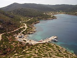
It comprises the archipelagos of Cíes, Ons, Sálvora and Cortegada. The park covers a land area of 1,200 ha (3,000 acres) and a sea area of 7,200 ha (18,000 acres) [13]
Monfragüe Salto del Gitano, Parque Nacional de Monfrague.jpg Cáceres Extremadura 200718,396 ha
(45,458 acres)
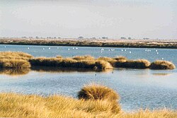
Three main habitats predominate: Mediterranean woodland and scrubland, dehesas, rocky areas and water bodies (rivers and reservoirs). More than 200 vertebrate species breed in the park, many others hibernate or can be seen on passage during migration to other latitudes. Birds are the group of vertebrates with the greatest abundance of species and individuals. [14]
Ordesa y Monte Perdido Valle ordesa.jpg Huesca Aragon 191815,608 ha
(38,568 acres)
High mountain park in the transition between the Euro-Siberian and Mediterranean regions, glacial erosion formations and high biodiversity. [15]
Picos de Europa Lamedo I.jpg Asturias, León and Cantabria Asturias, Castile-Leon and Cantabria 191867,127 ha
(165,874 acres)
Covers the mountain range Picos de Europa (part of the Cantabrian Mountains) and consists of three massifs: Central, Western and Eastern. Torre de Cerredo, at 2,646 meters (8,681 ft), is the highest mountain. [16] [17]
Sierra Nevada DSCN0427.JPG Granada, Almería, and Málaga Andalusia 199985,883 ha
(212,222 acres)
The park has fifteen peaks over 3,000 meters (9,800 ft) altitude, including Mulhacén, the highest mountain in the Iberian Peninsula, with a peak of 3,482 meters (11,424 ft). [18] [19]
Sierra de las Nieves Sierra de las Nieves.jpg Malaga Andalusia 202122,979.76 haThe true hallmark of this territory are the Spanish fir forests, a botanical relic of the Tertiary conifer forests, endemic to the mountain ranges of Malaga and Cadiz, and which have in this protected natural area their largest area of distribution in the world with nearly 2,000 hectares. [20]
Tablas de Daimiel TablasDeDaimiel1.jpg Ciudad Real Castile-La Mancha 19733,030 ha
(7,487 acres)
The park is the last surviving example of floodplain wetlands located in the arid central part of the Iberian peninsula. [21] [22]
Teide Teide Tenerife3.jpg Santa Cruz de Tenerife (Tenerife island) Canary Islands 195418,990 ha
(46,925 acres)
Atop the highest mountain of Spain, this national park, also a UNESCO world heritage site, features volcanic mountains, various plant species including the fragile species such as the Canary Island cedar and the Canaray island pine, and a few birds and animals. [23]
Timanfaya 2008-12-19 Lanzarote Timanfaya.jpg Las Palmas (Lanzarote island) Canary Islands 19745,107 ha
(12,620 acres)
The only National Park in Spain which is entirely geological, representing recent and historical volcanism in the Macaronesian Region. The last volcanic eruptions occurred during the 18th century as well as on the 19th century. [24] [25]

See also

Related Research Articles

<span class="mw-page-title-main">Province of Ciudad Real</span> Province of Spain

The province of Ciudad Real is a province in the southwestern part of the autonomous community of Castile-La Mancha, Spain. It is bordered by the provinces of Cuenca, Albacete, Jaén, Córdoba, Badajoz, and Toledo. It is partly located in the old natural region of La Mancha. Its capital is Ciudad Real. It is the third largest province by area in all of Spain, after Cáceres and Badajoz. The historic comarca Campo de Calatrava is located in the center of the province.

<span class="mw-page-title-main">Sierra Nevada (Spain)</span> Mountain range in southern Spain

Sierra Nevada is a mountain range in the Andalusian province of Granada in Spain. It contains the highest point of continental Spain: Mulhacén, at 3,479 metres (11,414 ft) above sea level.

<span class="mw-page-title-main">Timanfaya National Park</span> National park and biosphere reserve in the Canary Islands, Spain

Timanfaya National Park is a Spanish national park in the southwestern part of the island of Lanzarote, in the Canary Islands. It covers parts of the municipalities Tinajo and Yaiza. The area is 51.07 square kilometres (19.72 sq mi), and the parkland is entirely made up of volcanic soil. The statue El Diablo by César Manrique is its symbol. It is the only National Park in Spain which is entirely geological. Timanfaya National Park represents a sign of recent and historical volcanism in the Macaronesian Region. The last volcanic eruptions occurred during the 18th century as well as in the 19th century.

<span class="mw-page-title-main">Cabañeros National Park</span>

Cabañeros National Park is a national park in the Montes de Toledo, Spain. It falls within two provinces, the northwest of Ciudad Real and the southwest of Toledo.

<span class="mw-page-title-main">Teide National Park</span> National park in Tenerife, Spain

Teide National Park is a national park located in Tenerife, Canary Islands, Spain.

<span class="mw-page-title-main">Asturian Mountain cattle</span> Breed of cattle

Asturian Mountain is a local Spanish breed of cattle named after the Asturias, which possess breeding capacity and docility. They are primarily raised in the east of Asturias, in the north of Spain, particularly in the mountain range of the Picos de Europa, including within the National Park of Covadonga. The breed is also known as the Casina They are beef cattle and one of three breeds used to produce Casín cheese.

<span class="mw-page-title-main">Spain–Ukraine relations</span> Bilateral relations

Relations between Spain and Ukraine were established in January 1992, some time after the Ukrainian independence. Spain is a member of the European Union, which Ukraine applied for in 2022. Both nations are members of the Council of Europe.

<span class="mw-page-title-main">Sierra de las Quijadas National Park</span>

The Sierra de las Quijadas National Park is a national park located in the northwestern part of the Argentine province of San Luis. It was established on December 10, 1991, to protect the natural features, representative of the Semiarid Chaco and the High Monte ecoregions.

<span class="mw-page-title-main">Asturian Valley cattle</span> Breed of cattle

Asturian Valley cattle originate from the valleys of Asturias, Spain. They are mostly raised in the northern coastal areas on the Bay of Biscay and the river valleys at the foot of the Cordillera Cantábrica mountain range. This breed belongs to an exclusive bovine group in Spain known as the tronco Cantábrico that only includes breeds native to northern Spain; it also includes the Asturian Valley cattle. of all those breeds, Asturian Valley maintain the largest number. Traditionally the cattle were used for milk, meat, and work. Since other milk breeds have been introduced to Spain, their prominence has declined in the dairy industry. They remain one of three breeds that may be used to produce Casín cheese.

The National System of Protected Areas (SINAP) is the Colombian national park administrator. It is a department under the Ministry of the Environment, Housing and Regional Development responsible for the conservation and sustainable use of biological diversity. SINAP was established after Colombia signed the Convention on Biological Diversity through Law 165 of 1994, and has been the primary activity of the Colombian Government regarding the conservation of biodiversity. The areas of the Park System supply 25 million people with water.

<span class="mw-page-title-main">Casín cheese</span> Asturian semi-hard cheese

Casín cheese is a Spanish cheese made in the Principality of Asturias. Its name is covered by a protected designation of origin (PDO). It is made from full-fat, unpasteurized cows' milk from specific breeds, namely Asturian Mountain, Asturian Valley (Asturiana de la Valles), Friesian and any crosses between these breeds. Specifically the geographic area of manufacture is the southern part of Asturias which includes the Redes Natural Park and associated land, this is within the municipalities of Caso, Sobrescobio and Piloña. The cheese is classified as hard and semi-hard, and can be semi-cured or cured. It takes its name from one of the breeds of cattle whose milk is used, in turn named after the town of Caso. The shape of the cheese is a thick disc-shape, sometime more conical, of 10–20 cm diameter and 4–7 cm in height. The weight is between 250 and 1,000 g.

<span class="mw-page-title-main">Sierra de las Nieves National Park</span>

The Sierra de las Nieves National Park is a national park in the Sierra de las Nieves range, Andalusia, southern Spain. It is located behind Marbella and to the east of the road to Ronda from the Costa del Sol. In 2019 it was approved to become the sixteenth Spanish national park, the third in Andalusia. On July, 1st, 2021 it was declared National Park.

<span class="mw-page-title-main">Celtic pig</span> Breed of pig

The Celtic pig is a breed of pig native to the autonomous community of Galicia in north-western Spain.

<span class="mw-page-title-main">El Tamá National Park</span>

The El Tamá National Park It is a protected area with the status of a national park that is located between the Andes and plains of Venezuela. It protects part of the Tamá Massif. It has an area of 139,000 hectares and is located in the states of Táchira and Apure, near the border with Colombia. Created as a National Park on December 12, 1978, by the then President Carlos Andrés Pérez.

<span class="mw-page-title-main">Administración de Parques Nacionales</span>

The National Parks Administration of Argentina is a public agency in charge of maintaining the network of national parks, created in 1934 to preserve the biological diversity and the cultural resources of the country. It is managed by the Ministry of Environment and Sustainable Development.

<span class="mw-page-title-main">Ministry of Environment (Spain)</span>

The Ministry for the Ecological Transition and the Demographic Challenge (MITECO) is the department of the Government of Spain responsible for developing the government policy on fight against climate change, prevention of pollution, protecting the natural heritage, biodiversity, forests, sea, water and energy for a more ecological and productive social model. Likewise, it is responsible for the elaboration and development of the government policy against the country's demographic challenges.

<span class="mw-page-title-main">National Parks Autonomous Agency</span>

The National Parks Autonomous Agency (OAPN) is an autonomous agency of the Spanish central government that manages the National Parks Network and the Spanish Biosphere Reserves Network, as well as mountains, farms and other patrimonial assets of its property. The agency was created on June 23, 1995 by the Agriculture Minister Luis María Atienza by merging two other agencies, the Institute for the Conservation of Nature (ICONA) and the National Institute for Agrarian Reform and Development (IRYDA).

<span class="mw-page-title-main">Ministry of the Environment and Sustainable Development (Argentina)</span> Former ministry of Argentina

The Ministry of the Environment and Sustainable Development of Argentina was a ministry of the national executive power that oversaw the government's policy on environmental issues and promotes sustainable development.

<span class="mw-page-title-main">Valsain Valley</span> Valley in Segovia (Spain)

Valsain Valley is a valley of the northern slope of the Guadarrama mountain range. It is located in the southeastern part of the province of Segovia, within the municipality of Real Sitio de San Ildefonso, and borders the Community of Madrid. The valley is covered by an extensive pine forest known as el Pinar, the largest in the mountains and one of the best preserved in Spain.

References

  1. https://www.miteco.gob.es/es/red-parques-nacionales/la-red/gestion/visitasppnn_tcm30-67283.pdf [ bare URL PDF ]
  2. Millet, Daniel (10 February 2014). "El Teide se sitúa entre los diez parques nacionales más visitados del mundo". La Opinión de Tenerife (in Spanish). Retrieved 5 November 2015.
  3. "Aigüestortes i Estany de Sant Maurici: El medio natural". magrama.gob.es (in Spanish). Ministry of Agriculture, Food and Environment. 2015. Retrieved 4 November 2015.
  4. "Aigüestortes i Estany de Sant Maurici: Ficha técnica". magrama.gob.es (in Spanish). Ministry of Agriculture, Food and Environment. 2015. Retrieved 4 November 2015.
  5. "Cabañeros: Valores naturales". magrama.gob.es (in Spanish). Ministry of Agriculture, Food and Environment. 2015. Retrieved 4 November 2015.
  6. "Cabañeros: Ficha técnica". magrama.gob.es (in Spanish). Ministry of Agriculture, Food and Environment. 2015. Retrieved 4 November 2015.
  7. "Archipiélago de Cabrera: La isla". magrama.gob.es (in Spanish). Ministry of Agriculture, Food and Environment. 2015. Retrieved 4 November 2015.
  8. "Archipiélago de Cabrera: Ficha técnica". magrama.gob.es (in Spanish). Ministry of Agriculture, Food and Environment. 2015. Retrieved 4 November 2015.
  9. "Caldera de Taburiente: Ficha técnica". magrama.gob.es (in Spanish). Ministry of Agriculture, Food and Environment. 2015. Retrieved 4 November 2015.
  10. "Doñana: Ficha técnica". magrama.gob.es (in Spanish). Ministry of Agriculture, Food and Environment. 2015. Retrieved 4 November 2015.
  11. "Garajonay: Ficha técnica". magrama.gob.es (in Spanish). Ministry of Agriculture, Food and Environment. 2015. Retrieved 4 November 2015.
  12. "Sierra de Guadarrama: Ficha técnica". magrama.gob.es (in Spanish). Ministry of Agriculture, Food and Environment. 2015. Retrieved 4 November 2015.
  13. "Islas Atlánticas de Galicia: Ficha técnica". magrama.gob.es (in Spanish). Ministry of Agriculture, Food and Environment. 2015. Retrieved 4 November 2015.
  14. "Monfragüe: Ficha técnica". magrama.gob.es (in Spanish). Ministry of Agriculture, Food and Environment. 2015. Retrieved 4 November 2015.
  15. "Ordesa y Monte Perdido: Ficha técnica". magrama.gob.es (in Spanish). Ministry of Agriculture, Food and Environment. 2015. Retrieved 4 November 2015.
  16. "Picos de Europa: El medio natural". magrama.gob.es (in Spanish). Ministry of Agriculture, Food and Environment. 2015. Retrieved 4 November 2015.
  17. "Picos de Europa: Ficha técnica". magrama.gob.es (in Spanish). Ministry of Agriculture, Food and Environment. 2015. Retrieved 4 November 2015.
  18. "Sierra Nevada: Medio natural". magrama.gob.es (in Spanish). Ministry of Agriculture, Food and Environment. 2015. Retrieved 4 November 2015.
  19. "Sierra Nevada: Ficha técnica". magrama.gob.es (in Spanish). Ministry of Agriculture, Food and Environment. 2015. Retrieved 4 November 2015.
  20. miteco.gob.es (in Spanish). Ministry for the Ecological Transition. 2023 de las Nieves: Ficha técnica https://www.miteco.gob.es/es/red-parques-nacionales/nuestros-parques/sierra-de-las-nieves/ficha-tecnica/default.aspx=Sierra de las Nieves: Ficha técnica . Retrieved 18 January 2023.{{cite web}}: Check |url= value (help); Missing or empty |title= (help)
  21. Álvarez-Cobelas, M. & Cirujano, S. 1996. TDNP: Aquatic Ecology and Society (in Spanish). National Parks Autonomous Agency, Ministry of Environment.
  22. "Tablas de Daimiel: Ficha técnica". magrama.gob.es (in Spanish). Ministry of Agriculture, Food and Environment. 2015. Retrieved 4 November 2015.
  23. "Teide: Ficha técnica". magrama.gob.es (in Spanish). Ministry of Agriculture, Food and Environment. 2015. Retrieved 4 November 2015.
  24. "Timanfaya". Gobierno de Canarias. Retrieved 14 January 2021.
  25. "Timanfaya: Ficha técnica". magrama.gob.es (in Spanish). Ministry of Agriculture, Food and Environment. 2015. Retrieved 4 November 2015.