A caldera is a large cauldron-like hollow that forms shortly after the emptying of a magma chamber in a volcanic eruption. An eruption that ejects large volumes of magma over a short period of time can cause significant detriment to the structural integrity of such a chamber, greatly diminishing its capacity to support its own roof, and any substrate or rock resting above. The ground surface then collapses into the emptied or partially emptied magma chamber, leaving a large depression at the surface. Although sometimes described as a crater, the feature is actually a type of sinkhole, as it is formed through subsidence and collapse rather than an explosion or impact. Compared to the thousands of volcanic eruptions that occur over the course of a century, the formation of a caldera is a rare event, occurring only a few times within a given window of 100 years. Only eight caldera-forming collapses are known to have occurred between 1911 and 2018, with a caldera collapse at Kīlauea, Hawaii in 2018. Volcanoes that have formed a caldera are sometimes described as "caldera volcanoes".
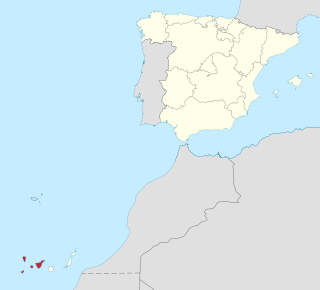
Province of Santa Cruz de Tenerife, also Province of Santa Cruz, is a province of Spain, consisting of the western part of the autonomous community of the Canary Islands. It consists of about half of the Atlantic archipelago: the islands of Tenerife, La Gomera, El Hierro, and La Palma. It occupies an area of 3,381 km2 (1,305 sq mi). It also includes a series of adjacent roques.

La Palma, also known as La isla bonita and historically San Miguel de La Palma, is the most northwesterly island of the Canary Islands, Spain, which is a Spanish autonomous community and archipelago in Macaronesia in the North Atlantic Ocean. La Palma has an area of 708.32 square kilometres (273.48 sq mi) making it the fifth largest of the eight main Canary Islands. The total population at the start of 2023 was 84,338, of which 15,522 lived in the capital, Santa Cruz de La Palma and 20,375 in Los Llanos de Aridane. Its highest mountain is the Roque de los Muchachos, at 2,426 metres (7,959 ft), being second among the peaks of the Canaries after the Teide massif on Tenerife.

Teide, or Mount Teide, is a volcano on Tenerife in the Canary Islands, Spain. Its summit is the highest point in Spain and the highest point above sea level in the islands of the Atlantic. If measured from the ocean floor, its height of 7,500 m (24,600 ft) makes Teide the third-highest volcano in the world, UNESCO and NASA rank it as Earth's third-tallest volcanic structure. Teide's elevation above sea level makes Tenerife the tenth highest island in the world.
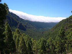
The Cumbre Vieja is an active volcanic ridge on the island of La Palma in the Canary Islands, Spain. The spine of Cumbre Vieja trends in an approximate north–south direction, comprising the southern half of La Palma, with both summit ridge and flanks pockmarked by dozens of craters and cones. The latest eruption began on 19 September 2021 in a forested area of Las Manchas locality known as Cabeza de Vaca. Voluminous lava flows quickly reached populated areas downslope, fanning out across settlements and banana plantations, destroying thousands of buildings and ultimately pouring over steep cliffs into the ocean to enlarge the island at several locations. The volcano went quiet on 13 December 2021, and on 25 December 2021, the local government declared the eruption to be over.

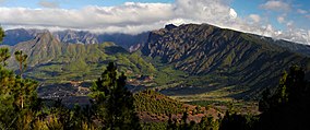
Roque de los Muchachos is a rocky mound at the highest point on the island of La Palma in the Canary Islands, Spain. The rocks are found at an elevation of 2,426 metres (7,959 ft) above sea level, not far from the Observatorio del Roque de los Muchachos, where some of the world's largest telescopes are situated; the altitude and the dryness of the climate here give rise to excellent observing conditions. The rocks are contained with the Parque Nacional de la Caldera de Taburiente.

Garafía is a municipality in the island of La Palma, Santa Cruz de Tenerife. Located in the northwest of the island, in the middle of two whims of nature: the ravines of Franceses bordering Barlovento and Izcagua by the South, bordering Punta Gorda. The administrative capital, home to the City Council, is called Santo Domingo; its parish church, Iglesia de Nuestra Señora de La Luz dates back to the 16th century. Garafía has a length of 25.50 km coastline.

Fuencaliente de La Palma, also Fuencaliente, is a municipality in the southern part of the island La Palma in the province of Santa Cruz de Tenerife of the Canary Islands, Spain. The seat of the municipality is the village Los Canarios. It has been the seat since 1837. The population of the municipality is 1,798 (2013) and the area is 56.42 km².

Tijarafe is a town and a municipality on the island of La Palma, Province of Santa Cruz de Tenerife, Canary Islands, Spain. It is situated in the northwestern part of the island. The population of the municipality is 2,776 (2013) and the area is 53.76 km². Tijarafe is 7 km northwest of Los Llanos de Aridane and 19 km west of the island capital Santa Cruz de La Palma.
El Paso, also known as Ciudad de El Paso, is a Spanish municipality located on the island of La Palma, province of Santa Cruz de Tenerife, Canary Islands.

Alonso Fernández de Lugo was a Spanish conquistador, city founder, and administrator. He conquered the islands of La Palma (1492–1493) and Tenerife (1494–1496) for the Castilian Crown; they were the last of the Canary Islands to be conquered by Europeans. He was also the founder of the towns of San Cristóbal de La Laguna, Santa Cruz de Tenerife and Santa Cruz de La Palma. One biographer has written that his personality was a “terrible mixture of cruelty and ambition or greed, on one part, and on the other a great capacity and sense for imposing order and government on conquered lands,” a trait found in the conquistadors of the New World.

Tanausu was the Guanche ruler of Aceró, on the island of La Palma, whose defeat by the Castilians marked the final conquest of that island. The island of Tenerife, conquered in 1495, was the last of the Canary Islands to fall under European control. His name has been translated as "The obstinate" or "He who has kidneys."
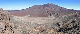
Teide National Park is a national park located in Tenerife, Canary Islands, Spain.
The 2011–2012 El Hierro eruption occurred just off the island of El Hierro, the second smallest and farthest south and west of the Canary Islands, in the Atlantic Ocean off the coast of Africa. The island is also the youngest in the volcanic chain. The October 2011 – March 2012 eruption was underwater, with a fissure of vents located approximately 2 kilometres to the south of the fishing village of La Restinga on the southern coast of the island. Increased seismicity in June 2012 to the north-west of the vent did not result in another phase of eruptive activity. Until the 2021 La Palma eruption, which started on 19 September 2021, this was the last volcanic eruption in Spain.

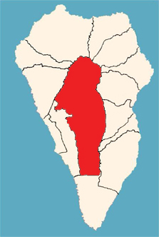
Idafe Rock is a natural stone pillar located in Caldera de Taburiente National Park on the island of La Palma in the Canary Islands.

The geology of the Canary Islands is dominated by volcanoes and volcanic rock. The Canary Islands are a group of volcanic islands in the North Atlantic Ocean, near the coast of Northwest Africa. The main islands are Lanzarote, Fuerteventura, Gran Canaria, Tenerife, La Gomera, La Palma, and El Hierro. There are also some minor islands and islets. The Canary Islands are on the African tectonic plate but they are far from the plate's edges; this controls the type of volcanic activity, known as intraplate volcanism, that has formed the islands.
The Canary Islands dry woodlands and forests is a Mediterranean forests, woodlands, and scrub ecoregion in the Canary Islands. It encompasses the western group of the Canary Islands – La Palma, El Hierro, La Gomera, Tenerife, and Gran Canaria – in the Atlantic Ocean. These volcanic islands are an autonomous community of Spain, and lie southwest of the Spanish mainland and west of the North African coast.
The island of La Palma in the Canary Islands is at risk of undergoing a large landslide, which could cause a tsunami in the Atlantic Ocean. Volcanic islands and volcanoes on land frequently undergo large landslides/collapses, which have been documented in Hawaii for example. A recent example is Anak Krakatau, which collapsed to cause the 2018 Sunda Strait tsunami.

An eruption at the Cumbre Vieja volcanic ridge, comprising the southern half of the Spanish island of La Palma in the Canary Islands, took place between 19 September and 13 December 2021. It was the first volcanic eruption on the island since the eruption of Teneguía in 1971. At 85 days, it is the longest known and the most damaging volcanic eruption on La Palma since records began. The total damage caused by the volcano amounts up to 843 million euros.