Sierra de las Nieves National Park

Last updated
Sierra de las Nieves National Park
Parque Nacional de la Sierra de las Nieves
Sierra de las Nieves.jpg
Sierra de las Nieves National Park
Location of Sierra de las Nieves
Location Province of Málaga, Spain
Nearest city Tolox
Coordinates 36°41′00″N05°00′00″W / 36.68333°N 5.00000°W / 36.68333; -5.00000
Area93,930 ha (362.7 sq mi)
EstablishedJuly 28, 1989 (1989-07-28)
Visitors100,000

The Sierra de las Nieves National Park (Spanish : Parque Nacional de la Sierra de las Nieves) is a national park in the Sierra de las Nieves range, Andalusia, southern Spain. It is located behind Marbella and to the east of the road to Ronda from the Costa del Sol. In 2019, the Council of Ministers proposed to Parliament the transformation of the Natural Park into a National Park. [1] On 1 July 2021, King Felipe VI gave royal assent to the Sierra de las Nieves National Park Act, which declares it as a National Park. [2]

Contents

Sierra de las Nieves stands out for the great variety of landscapes and ecosystems it boasts and this is due to the complex geology and geomorphology it presents, as well as the special climatic conditions to which it is exposed.

The true hallmark of this territory are the Spanish fir forests, a botanical relic of the Tertiary conifer forests, endemic to the mountain ranges of Malaga and Cadiz, and which have in this protected natural area their largest area of distribution in the world with nearly 2,000 hectares. [3]

Caves

There are a considerable number of large caves in the park, several taking the traditional form of horizontal caverns. Three are of particular interest,[ according to whom? ] namely Hoyos del Pilar, Hoyos de Lifa and Cuevas del Moro.

The area is known for its shafts. One of these, GESM, is one of the deepest in Europe and was named after the Grupo de Exploraciones Subterráneas de Málaga (GESM) which explored it in September 1978. The entrance to this shaft is located at 1670 m and descends 1098 m with a few large drops. The Gran Pozo drops 115 m and the Pozo Paco de la Torre has a vertical fall of 194 m. At a depth of 900 m there are some interesting rock formations in the Sala de Maravillas, and Lake Ere is located almost at the bottom. It has still[ when? ] not been fully explored.

Sima de la Tinaja is located in the area of the Tajo de la Caina at an altitude of 760 m. It is 54 m deep. It can be reached from Tolox. Many prehistoric artefacts have been recovered from this cave and many are to be found in the Málaga Museum.

Some of the other shafts are mentioned here. The list is by no means exclusive and many are surely yet to be discovered.

Tourism

There is a network of accommodation and tourist services that allow it to be visited comfortably and enjoy its beauty.

The national park has an extensive network of paths and trails that allow hiking, although the scarcity of water sources in the area should be taken into account. There are two main accesses that lead to the heart of the park: one from the Ronda road to San Pedro de Alcántara, along a forest track that leads to the Los Quejigales recreational area, and another from Yunquera along a forest track that reaches the Pº Saucillo viewpoints, and Caucón or Luis Ceballos. There are also accesses through the town of Tolox, Istán and El Burgo. The main routes of the national park are Quejigales-Torrecilla and Pº Saucillo-Torrecilla which lead to the highest peak in western Andalusia. Another popular path is the Mirador Ceballos-Tajo de la Caína, which leads to the Pinsapar de Caucón and allows you to observe the impressive landscapes that exist from the Tajo de la Caína. [4]

The towns of the region also have many places to visit and stand out for their historical heritage and for their unique festivals, such as the Polvos and the Cohetá de Tolox, the Alozaina Flour Carnival, the Siete Ramales Soup and the Quema de Judas in El Burgo or Corpus Christi in Yunquera.

Threats

Overgrazing has been one of the main causes that has hindered the regeneration of many areas, a threat that has decreased with the regulation of livestock use. It is widely accepted that moderate loads do not reduce, and even stimulate, pasture productivity, maintain high levels of biological diversity, and reduce fire risk. However, the overload of livestock in the mountains leads to the reduction of plant cover and the simplification of its structure and composition, seriously damaging the natural regeneration of tree and shrub species. In fact, overgrazing is responsible for the strong erosion suffered by the highest areas of the sierra, preventing the regeneration of the high mountain gall oak. [5]

Another important threat factor is derived from climate change. High temperatures and prolonged droughts will enhance the negative effects of forest fires, pests and diseases in the future and consequently increase the risk of soil erosion. The latter can be seen equally intensified as a result of the increase in the irregularity and torrentiality of precipitation and the topography of the area. In addition, studies carried out reflect a reduction in the potential habitat of the Spanish fir at the end of the 21st century. [6]

In relation to forest pests and diseases, the fungi Heterobasidium annosum and Armillaria mellea, together with the lepidoptera Dioryctria aulloi and the borer Cryphalus numidicus have caused numerous damages to the Spanish fir during the last decades. It is considered likely that its expansion has been favored by the weakening of plant formations as a result, among other things, of periods of drought, although currently the phytosanitary status of the Spanish firs has reached an “ecological balance”. The Ministry of Agriculture, Livestock, Fisheries and Sustainable Development is carrying out a Pinsapo Recovery Plan9 through which conservation actions are being carried out, which began in the mid-20th century and culminated in 2011 with the approval of said plan, consisting of the protection and improvement of the existing populations, as well as the restoration of their habitat, attempting to regenerate and reforest the areas in which they have disappeared as a result of the forest fires. [7]

Related Research Articles

<span class="mw-page-title-main">Province of Cádiz</span> Province of Spain

Cádiz is a province of southern Spain, in the southwestern part of the autonomous community of Andalusia. It is the southernmost part of mainland Spain, as well as the southernmost part of continental Europe.

<span class="mw-page-title-main">Baetic System</span>

The Baetic System or Betic System is one of the main systems of mountain ranges in Spain. Located in the southern and eastern Iberian Peninsula, it is also known as the Cordilleras Béticas or Baetic Mountains. The name of the mountain system derives from the ancient Roman region of Baetica, one of the Imperial Roman provinces of ancient Hispania.

<i>Abies pinsapo</i> Species of plant in the family Pinaceae

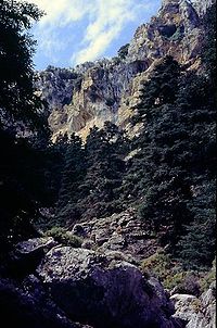
Abies pinsapo, Spanish fir, is a species of tree in the family Pinaceae, native to southern Spain and northern Morocco. Related to other species of Mediterranean firs, it appears at altitudes of 900–1,800 metres (3,000–5,900 ft) in the Sierra de Grazalema in the Province of Cádiz and the Sierra de las Nieves and Sierra Bermeja, both near Ronda in the province of Málaga. In Morocco, it is limited to the Rif Mountains at altitudes of 1,400–2,100 metres (4,600–6,900 ft) on Jebel Tissouka and Jebel Tazaot.

<span class="mw-page-title-main">Álora</span> Municipality in Andalusia, Spain

Álora is a town and municipality in southern Spain in the province of Málaga, in the autonomous community of Andalusia. Located c. 40 km from Málaga, on the right bank of the river Guadalhorce and on the Córdoba-Málaga railway, within the comarca of Valle del Guadalhorce. It is a typical pueblo blanco, a whitewashed village nestled between three rocky spurs topped by the ruins of the castle.

<span class="mw-page-title-main">Sierra de las Nieves</span>

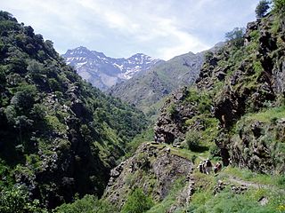
Sierra de las Nieves is a mountain range of the Penibaetic System in Málaga Province, Andalusia, Spain with its highest point being La Torrecilla

<span class="mw-page-title-main">Tolox</span> Place in Andalusia, Spain


Tolox is a town and municipality in the province of Málaga in the autonomous community of Andalusia in southern Spain. The municipality has a population of 2,317 (2006). It is situated in the centre of the Sierra de las Nieves Nature Park at the foot of the Sierra Blanca and the Sierra Parda. In addition to La Torrecilla peak, there are ancient woodlands of Spanish Fir and gall oak. The municipality covers 94 km2, has a mean elevation of 285 m. and mean geographical coordinates of 36° 41' 11" N, 4° 54' 16" E. The channel of the Rio Grande flows through the town from northeast to south.

<span class="mw-page-title-main">Los Alcornocales Natural Park</span>

Los Alcornocales Natural Park is a natural park located in the south of Spain, in the autonomous community of Andalusia; it is shared between the Province of Cádiz and Málaga. The natural park occupies a territory spanning seventeen municipalities with a total population of about 380,000. Los Alcornocales means "the cork oak groves".

<span class="mw-page-title-main">Sierra de Grazalema Natural Park</span>

The Sierra de Grazalema Natural Park is a natural park in the northeastern part of the province of Cádiz in southern Spain. The park encompasses, within its 51,695 hectares, a complex of mountain ranges, known collectively as the Sierra de Grazalema, which, in turn, are part of the Cordillera Subbética. Other ranges within the park, comprising the Sierra de Grazalema, include the Sierra de Zafalgar, the Sierra del Pinar, and the Sierra de Endrinal. Pinar, 1,654 metres (5,427 ft) in elevation, is the tallest peak.

<span class="mw-page-title-main">Monda</span> Place in Andalusia, Spain

Monda is a town and municipality in the province of Málaga, part of the autonomous community of Andalusia in southern Spain. It is located near Sierra Blanca and Sierra de las Nieves in the comarca of Sierra de las Nieves. The municipality is situated approximately 44 kilometres from the provincial capital of Málaga and 10 from Coín. Monda has an altitude of 427 metres. It has a population of approximately 2,000 residents. The natives are called Mondeños.

<span class="mw-page-title-main">Guadalevín</span> River in Spain

The Guadalevín is a tributary of the river Guadiaro in Málaga, Andalusia, Spain. Its gorge divides the city of Ronda where it is spanned by three bridges, Puente Nuevo, Puente Viejo and Puente Romano.

<span class="mw-page-title-main">Sierra de San Pedro</span>

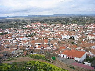
Sierra de San Pedro is a mountain range in the greater Montes de Toledo range, Spain. It is named after Saint Peter the apostle and rises in the limits of Cáceres and Badajoz Provinces, in the western part of the autonomous community of Extremadura close to its border with Portugal. This range gives its name to the Sierra de San Pedro - Los Baldíos comarca.

<span class="mw-page-title-main">Sierra de Huétor and la Alfaguara Natural Park</span> Natural park in Andalusia, Spain

The Sierra de Huétor and la Alfaguara Natural Park is a natural park in Andalusia, Spain. It is located near Granada city and was established in 1989.

Sierra Blanca is a mountain range of the Penibaetic System in Málaga Province, Andalusia, Spain. Its highest point is the 1,275 m high Pico del Lastonar. It is the closest mountain to Marbella.

<span class="mw-page-title-main">Sierra de Gredos Regional Park</span>

Sierra de Gredos Regional Park is a protected natural area in Spain, covering 86,397 hectares. The estimated population within the socio-economic influence area is 21,182. The law that declared the status of the park was published in the BOE on July 22, 1996.

<span class="mw-page-title-main">El Chico National Park</span> National park in Hidalgo State, Mexico

El Chico National Park is a protected area in the State of Hidalgo, Mexico. It is one of the oldest protected areas in Mexico, as its foundation dates to 1898 when the then president of the republic, General Porfirio Díaz, by decree, created "Monte Vedado del Mineral del Chico". Since this date, the ancient conifer forests have been protected from the deforestation suffered in other parts of the country. Another decree followed in 1915 and still another by Presidential Agreement on 13 September 1922, which declared Monte Vedado to be cataloged as a forest reservation.

<span class="mw-page-title-main">Iberian conifer forests</span> Mediterranean forests, woodlands and scrub ecoregion in southwestern Europe

The Iberian conifer forests is a Mediterranean forests, woodlands, and scrub ecoregion in southwestern Europe. It includes the mountain forests of southern and central Spain.

<span class="mw-page-title-main">Cuenca Alta del Manzanares Regional Park</span>

The Cuenca Alta del Manzanares Regional Park, created in 1985, is the natural space protected area with the largest extension in the Community of Madrid (Spain) and one of the most ecologically and scenically valuable. It is located in the northwest of the region and extends around the upper course of the Manzanares River, along 42 583 ha. Its main municipalities of reference are Manzanares el Real and Hoyo de Manzanares. Unesco declared it a Biosphere Reserve in 1992.

<span class="mw-page-title-main">Sierra de Hoyo de Manzanares</span> Mountain chain in Spain

The Sierra de Hoyo or Sierra de Hoyo de Manzanares is a mountain chain located in the northwest of the Community of Madrid (Spain), near the Sierra de Guadarrama. Geologically it belongs to this mountainous formation, but there is a flat separation of about ten kilometers between the two. Its main municipality of reference is Hoyo de Manzanares, located on its southern slope, from which it takes its name.

References

  1. "El BOE publica la aprobación de la propuesta de declaración del Parque Nacional de la Sierra de las Nieves". Diario Sur (in Spanish). 8 January 2019. Retrieved 17 July 2020.
  2. "Ley 9/2021, de 1 de julio, de declaración del Parque Nacional de la Sierra de las Nieves". boe.es (in Spanish). 3 July 2021.
  3. "Decreto 162/2018, de 4 de septiembre, por el que se aprueban el Plan de Ordenación de los Recursos Naturales del ámbito de Sierra de las Nieves y el Plan Rector de Uso y Gestión del Parque Natural Sierra de las Nieves".
  4. Sánchez, Nacho (2019-01-30). "Bosques prehistóricos y pueblos blancos en la sierra de las Nieves". EL PAÍS (in Spanish). Retrieved 2022-05-15.
  5. Alvarez Calvente (1996). "Repoblaciones y trabajos de regeneración en el Pinsapar de la Sierra de las Nieves".
  6. J. C. Linares • J. A. Carreira • V. Ochoa (2011). "Human impacts drive forest structure and diversity. Insights from Mediterranean mountain forest dominated by Abies pinsapo (Boiss.)".{{cite journal}}: Cite journal requires |journal= (help)
  7. Plan de Recuperación del Pinsapo