List of national parks of Finland

Last updated

There are 41 national parks in Finland. They are all managed by the Metsähallitus. The national parks cover a total area of 9,892 square kilometres (3,819 sq mi) – 2.7% of Finland's total land area.

Contents

A total of 3.2 million people visited the parks in 2018. [1] During the COVID-19 pandemic, the number of national park visitors strongly increased, with a total of 8.5 million people visiting the parks in 2021. [2]

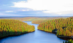
Lake Pielinen seen from a hill in Koli National Park. Koli rotated.jpg
Lake Pielinen seen from a hill in Koli National Park.

List of national parks

National parkPhotoRegionLand area (km2)EstablishedVisitation (2021) [3] Coordinates
Archipelago Gullkrona-overblick.jpg Southwest Finland 500198284,000 59°54′53″N21°52′39″E / 59.91472°N 21.87750°E / 59.91472; 21.87750 (Archipelago National Park)
Bothnian Bay Bothnian Bay Kemi.jpg Lapland 2.519916,300 65°37′N024°19′E / 65.617°N 24.317°E / 65.617; 24.317 (Perämeri National Park)
Teijo Matildanjarvi Mathildedal Pernio Salo Finland January 2015.jpg Southwest Finland 33.852015104,700 60°13′26″N022°57′37″E / 60.22389°N 22.96028°E / 60.22389; 22.96028 (Teijo National Park)
Salla Old Sallatunturit, Airistunturi and Vitarinne in Russia behind Tunturilammit as seen from the lower Peak of Sallatunturit in Salla, Lapland, Finland.jpg Lapland 99.832022
Bothnian Sea Sapin satama.JPG Southwest Finland & Satakunta 913201195,300 61°32′06″N21°33′50″E / 61.53500°N 21.56389°E / 61.53500; 21.56389 (Bothnian Sea National Park)
Eastern Gulf of Finland Ulko-Tammio.jpg Kymenlaakso 6.7198216,300 60°17′5″N27°16′26″E / 60.28472°N 27.27389°E / 60.28472; 27.27389 (Eastern Gulf of Finland National Park)
Ekenäs Archipelago Sundharu Jussaro.jpg Uusimaa 52198959,400 59°49′22″N23°27′15″E / 59.82278°N 23.45417°E / 59.82278; 23.45417 (Ekenäs Archipelago National Park)
Helvetinjärvi Helvetinkolu.jpg Pirkanmaa 49.8198267,000 62°2′N23°51′E / 62.033°N 23.850°E / 62.033; 23.850 (Helvetinjärvi National Park)
Hiidenportti Hiidenportin kansallispuisto.jpg Kainuu 45198215,000 63°52′22″N29°3′31″E / 63.87278°N 29.05861°E / 63.87278; 29.05861 (Hiidenportti National Park)
Hossa Housivirta.jpg Kainuu 112017112,900 65°29′23″N29°19′25″E / 65.48972°N 29.32361°E / 65.48972; 29.32361 (Hossa National Park)
Isojärvi Isojarvi Isojarven kansallispuisto 2.jpg Central Finland 19198230,200 61°41′54″N25°0′39″E / 61.69833°N 25.01083°E / 61.69833; 25.01083 (Isojärvi National Park)
Kauhaneva-Pohjankangas Kauhaneva.jpg Southern Ostrobothnia / Satakunta 57198229,700 62°10′45″N22°24′23″E / 62.17917°N 22.40639°E / 62.17917; 22.40639 (Kauhaneva-Pohjankangas National Park)
Koli Koli hill view.jpg North Karelia 301991256,900 63°3′27″N29°53′14″E / 63.05750°N 29.88722°E / 63.05750; 29.88722 (Koli National Park)
Kolovesi KolovesiRocks.jpg Southern Savonia 23199017,200 62°15′27″N28°49′0″E / 62.25750°N 28.81667°E / 62.25750; 28.81667 (Kolovesi National Park)
Southern Konnevesi Lake Konnevesi Mustalahti.jpg Central Finland / Northern Savonia 15.44201438,600 62°33′30″N26°38′50″E / 62.55833°N 26.64722°E / 62.55833; 26.64722 (Southern Konnevesi National Park)
Kurjenrahka Savojarvi near Kurjenpesa.jpg Southwest Finland 29199877,600 60°43′14″N22°23′1″E / 60.72056°N 22.38361°E / 60.72056; 22.38361 (Kurjenrahka National Park)
Lauhanvuori Lauhanvuori 5.jpg Southern Ostrobothnia 53198220,500 62°09′7″N22°10′30″E / 62.15194°N 22.17500°E / 62.15194; 22.17500 (Lauhanvuori National Park)
Leivonmäki Leivonmaki National Park I.jpg Central Finland 29200333,400 61°56′N26°2′E / 61.933°N 26.033°E / 61.933; 26.033 (Leivonmäki National Park)
Lemmenjoki River at Lemmenjoki national park, Finland IMG 0330.JPG Lapland 2,850195629,500 68°30′N25°30′E / 68.500°N 25.500°E / 68.500; 25.500 (Lemmenjoki National Park)
Liesjärvi Saruwine - Faery Tale Forest (by-sa).jpg Tavastia Proper 22195660,100 60°40′50″N23°51′30″E / 60.68056°N 23.85833°E / 60.68056; 23.85833 (Liesjärvi National Park)
Linnansaari Linnansaari1.jpg Southern Savonia / Northern Savonia 38195636,000 62°6′38″N28°30′34″E / 62.11056°N 28.50944°E / 62.11056; 28.50944 (Linnansaari National Park)
Nuuksio Mustalampi Lake in Nuuksio.jpg Uusimaa 451994314,500 60°18′27″N24°29′57″E / 60.30750°N 24.49917°E / 60.30750; 24.49917 (Nuuksio National Park)
Oulanka FI-Oulanka NP1.jpg Northern Ostrobothnia / Lapland 2701956253,300 66°22′32″N29°20′19″E / 66.37556°N 29.33861°E / 66.37556; 29.33861 (Oulanka National Park)
Päijänne Paijanne and paijatsalo.jpg Päijänne Tavastia 14199315,000 61°23′12″N25°23′36″E / 61.38667°N 25.39333°E / 61.38667; 25.39333 (Päijänne National Park)
Pallas-Yllästunturi Pallastunturi Finland.jpg Lapland 1,0202005699,200 68°9′32″N24°2′25″E / 68.15889°N 24.04028°E / 68.15889; 24.04028 (Pallas-Yllästunturi National Park)
Patvinsuo Patvinsuo kohosuota.jpg North Karelia 105198220,200 63°6′41″N30°42′16″E / 63.11139°N 30.70444°E / 63.11139; 30.70444 (Patvinsuo National Park)
Petkeljärvi Kuikan kierros.jpg North Karelia 6195629,800 62°35′N31°11′E / 62.583°N 31.183°E / 62.583; 31.183 (Petkeljärvi National Park)
Puurijärvi-Isosuo Isosuo mire at Puurijarvi-Isosuo NP.jpg Pirkanmaa / Satakunta 27199321,700 61°14′57″N22°34′1″E / 61.24917°N 22.56694°E / 61.24917; 22.56694 (Puurijärvi-Isosuo National Park)
Pyhä-Häkki Pyha-Hakki National Park 5.jpg Central Finland 13195621,400 62°50′44″N25°28′21″E / 62.84556°N 25.47250°E / 62.84556; 25.47250 (Pyhä-Häkki National Park)
Pyhä-Luosto Isokuru.JPG Lapland 1422005232,700 67°3′59″N26°58′25″E / 67.06639°N 26.97361°E / 67.06639; 26.97361 (Pyhä-Luosto National Park)
Repovesi Repoveden Kansallispuisto Kesayonauringossa.jpg Kymenlaakso / Southern Savonia 152003172,900 61°11′N26°53′E / 61.183°N 26.883°E / 61.183; 26.883 (Repovesi National Park)
Riisitunturi Noukavaara - Riisitunturi - Posio - Finland.jpg Lapland 77198289,900 66°14′N28°30′E / 66.233°N 28.500°E / 66.233; 28.500 (Riisitunturi National Park)
Rokua Rokuan kansallispuisto.JPG Northern Ostrobothnia / Kainuu 4.3195662,600 64°33′22″N26°30′36″E / 64.55611°N 26.51000°E / 64.55611; 26.51000 (Rokua National Park)
Salamajärvi Salamajarvi national park.jpg Central Ostrobothnia / Central Finland 62198222,400 63°16′N24°45′E / 63.267°N 24.750°E / 63.267; 24.750 (Salamajärvi National Park)
Seitseminen Seitseminen-mylly.jpg Pirkanmaa 45.5198248,200 61°56′N23°26′E / 61.933°N 23.433°E / 61.933; 23.433 (Seitseminen National Park)
Sipoonkorpi Sipoonkorpi.jpg Uusimaa 18.62011146,400 60°18′54″N25°13′8″E / 60.31500°N 25.21889°E / 60.31500; 25.21889 (Sipoonkorpi National Park)
Syöte Syote National Park.jpg Northern Ostrobothnia / Lapland 2992000117,800 65°44′51″N27°54′43″E / 65.74750°N 27.91194°E / 65.74750; 27.91194 (Syöte National Park)
Tiilikkajärvi Tiilikkajarven kansallispuisto Venajanhiekka.jpg Northern Savonia / Kainuu 34198225,300 63°40′N28°18′E / 63.667°N 28.300°E / 63.667; 28.300 (Tiilikkajärvi National Park)
Torronsuo Torronsuo National Park.jpg Tavastia Proper 25.5199055,500 60°44′N23°37′E / 60.733°N 23.617°E / 60.733; 23.617 (Torronsuo National Park)
Urho Kekkonen Paratiisikuru waterfall.JPG Lapland 2,5501983446,300 68°13′5″N28°8′25″E / 68.21806°N 28.14028°E / 68.21806; 28.14028 (Urho Kekkonen National Park)
Valkmusa Valkmusan suolahde.jpg Kymenlaakso 17199625,400 60°34′N26°44′E / 60.567°N 26.733°E / 60.567; 26.733 (Valkmusa National Park)

See also

Other references on Wikipedia:

Related Research Articles

<span class="mw-page-title-main">Nuuksio National Park</span> National park in Uusimaa, Finland

Nuuksio National Park is one of Finland's 40 national parks. Established in 1994, the park spreads over an area of forests and lakes in Espoo, Kirkkonummi and Vihti. North-west from Helsinki, it is the second-closest national park to the capital behind the recently established Sipoonkorpi National Park. The name is derived from the Nuuksio district of Espoo.

Metsähallitus is a state-owned enterprise in Finland.

<span class="mw-page-title-main">Urho Kekkonen National Park</span> National park in Lapland, Finland

Urho Kekkonen National Park is a national park in Lapland, Finland, situated in area of municipalities of Savukoski, Sodankylä and Inari. Established in 1983 and covering 2,550 square kilometres (985 sq mi), it is one of Finland's largest protected areas. It is named after Urho Kekkonen, late President and Prime Minister of Finland.

<span class="mw-page-title-main">Rokua National Park</span> National park in Northern Ostrobothnia, Finland

Rokua National Park is a UNESCO Global Geopark in the Northern Ostrobothnia region of Finland.

<span class="mw-page-title-main">Hiidenportti National Park</span> National Park of Finland

Hiidenportti National Park is a national park in Sotkamo in the Kainuu region of Finland. Hiidenportti National Park was established in 1982 to preserve the region's wilderness. A mosaic mix of mires and dry forests is typical landscape in this national park. The park covers 45 square kilometres (17 sq mi).

<span class="mw-page-title-main">Koli National Park</span> National park in North Karelia region, Finland

Koli National Park is a national park in the municipalities of Joensuu, Lieksa and Kontiolahti in the North Karelia region of Finland. It covers 30 square kilometres (12 sq mi) of forested hills on the western shore of Lake Pielinen. The park was established in 1991 and is currently governed by the Metsähallitus. It was originally governed by the Finnish Forest Research Institute, which is also called the Metla.

<span class="mw-page-title-main">Linnansaari National Park</span> National park in Finland

Linnansaari National Park is a national park in the Southern Savonia and Northern Savonia regions of Finland. It lies in the middle of the lake Haukivesi, a part of greater Saimaa. The National Park was established to conserve the valuable natural features of the Finnish lakeland.

<span class="mw-page-title-main">Salamajärvi National Park</span> National park in Finland

Salamajärvi National Park is a national park in the Central Ostrobothnia and Central Finland regions of Finland, in the municipalities of Perho, Kivijärvi and Kinnula. Salamajärvi is located in the rugged watershed region of Suomenselkä. This large, uninhabited area is especially known for its diverse mire ecosystems and its set of wilderness animals.

<span class="mw-page-title-main">Ekenäs Archipelago National Park</span> National park in Finland

Ekenäs Archipelago National Park is situated in the Ekenäs archipelago, in the Uusimaa region of Finland. It was established in 1989 and covers 52 square kilometres (20 sq mi). The park is maintained by Metsähallitus.

<span class="mw-page-title-main">Päijänne National Park</span> National park in Finland

Päijänne National Park is a national park in Finland, in the southern parts of Lake Päijänne. It consists of 50 unbuilt islands and parts of inhabited islands. The national park was established in 1993 and has an area of 14 square kilometres (5.4 sq mi).

<span class="mw-page-title-main">Kolovesi National Park</span> National park in North Karelia and South Savo region in Finland

Kolovesi National Park is a national park in the Etelä-Savo region of Finland. It was established in 1990 and covers 23 km2 (8.9 sq mi). It protects e.g. the habitat of the critically endangered Saimaa Ringed Seal. Typical of the rugged scenery of Kolovesi, formed by the ice age, are craggy cliffs rising from the water. Cave paintings have been discovered in the area. Motor boats are prohibited in the area. Kayaking, canoeing, and rowing and facilitated, and there are also several marked hiking paths in the area.

<span class="mw-page-title-main">Kurjenrahka National Park</span> National park in Finland Proper region, Finland

Kurjenrahka National Park is a national park in Southwest Finland. It was established in 1998 and covers 29 square kilometres (11 sq mi). The area consists mainly of bog but also includes primeval forests, some of which have been unmanaged for over 150 years. The Eurasian lynx is a permanent resident of Kurjenrahka, but brown bears and gray wolves have also been observed and are known to reside in areas within or close to the park. Marked trails in the general area extend to over 300 km. It includes several lakes, such as Mynäjärvi.

<span class="mw-page-title-main">Lauhanvuori National Park</span> National park in Southern Ostrobothnia, Finland

Lauhanvuori National Park is a national park in the Southern Ostrobothnia region of Finland, on the border of Kauhajoki and Isojoki. It was established in 1982 and covers 53 square kilometres (20 sq mi).

<span class="mw-page-title-main">Kauhaneva–Pohjankangas National Park</span> National park in Finland

Kauhaneva–Pohjankangas National Park is a national park in the municipalities of Kauhajoki and Karvia in the Southern Ostrobothnia and Satakunta regions of Finland. Established in 1982, the park covers 57 square kilometres (22 sq mi). It consists of swamp areas, mainly bogs such as the 16.3-square-kilometre (6.3 sq mi) Kauhaneva bog, scattered around it.

<span class="mw-page-title-main">Riisitunturi National Park</span> National park in Lapland, Finland

Riisitunturi National Park is a national park in Posio, Finnish Lapland. It was established in 1982 and covers 77 square kilometres (30 sq mi). The park is in a mountainous area, and there are also many swamps, especially hillside swamps.

<span class="mw-page-title-main">Tiilikkajärvi National Park</span> National park in Finland

Tiilikkajärvi National Park is a national park in Finland, located both in Rautavaara, North Savonia and Sotkamo, Kainuu. It was established in 1982 and covers 34 square kilometres (13 sq mi).

<span class="mw-page-title-main">Patvinsuo National Park</span> National park in North Karelia region, Finland

Patvinsuo National Park is a national park in the North Karelia region of Finland, in the municipalities of Lieksa and Ilomantsi. It was established in 1982 and covers 105 square kilometres (41 sq mi). There are 80 kilometres (50 mi) of marked walking trails in the area. The park has bogs, former managed forest and slash-and-burn areas and some old-growth forests. Suomujärvi lake is located in the northeast area in the park.

<span class="mw-page-title-main">Archipelago National Park</span> National park in Finland

Archipelago National Park is a national park in Southwest Finland. It was established in 1983 and includes 500 km2 (190 sq mi) of land area. Most of the land is on islands smaller than 1 km2 (0.39 sq mi). The park encompasses about 2,000 of the 8,400 islets and skerries within the cooperative area. The larger islands are mainly owned by their inhabitants. Archipelago National Park is part of the UNESCO biosphere reserves and received a PAN Parks certificate in 2007.

<span class="mw-page-title-main">Eastern Gulf of Finland National Park</span> National park in Finland

The Eastern Gulf of Finland National Park is a national park in the Kymenlaakso region of Finland. It was established in 1982 and has a total land area of 6.7 square kilometres (2.6 sq mi).

The Vätsäri Wilderness Area is located along the northeastern shore of Lake Inari in Inari, northern Finland, stretching all the way to the Finland–Norway border. The landscape is dominated by taiga forests of Scots pine, bog and bodies of water. The northeastern part rises as a treeless fell ridge. Vätsäri is one of twelve wilderness areas in Lapland and covers an area of 1,550 square kilometers (600 sq mi). The wilderness has one marked trail and a few cabins. The reserve is under the management of Metsähallitus and was established with the other wilderness reserves in 1991. It is part of Pasvik–Inari Trilateral Park along with Øvre Pasvik National Park and Øvre Pasvik Landscape Protection Area in Norway, and the joint Norwegian–Russian Pasvik Nature Reserve.

References

  1. "The economic and health impacts of Finnish national parks increased in 2018 – positive development at risk without increase in funding". Metsähallitus. 2019-01-31. Archived from the original on 2019-04-22. Retrieved January 31, 2019.
  2. "Käyntimäärät Maastossa". metsa.fi (in Finnish). Archived from the original on 16 December 2021. Retrieved 23 June 2022.
  3. "Käyntimäärät Maastossa". metsa.fi (in Finnish). Archived from the original on 16 December 2021. Retrieved 23 June 2022.