National landscapes of Finland

Last updated

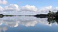
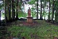
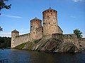
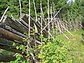
National landscapes of Finland were selected by the Finnish Ministry of the Environment in 1992 as a part of the 75th anniversary of the Independence of Finland. The 27 selected landscapes represent the special environmental and cultural features of Finland. They have great symbolic value and significance in cultural or historical terms. [1]

Contents

National landscapes

LandscapeMunicipalitiesHistorical
province
Modern
province
ImageCoordinates
Helsinki seascape Helsinki Uusimaa Uusimaa Helsinkimerelta--GFDL--.jpg 60°09′58″N24°57′21″E / 60.16605°N 24.955788°E / 60.16605; 24.955788
Tapiola Espoo Uusimaa Uusimaa Espoon Tapiola kesalla.jpg 60°10′35″N24°48′31″E / 60.176449°N 24.808494°E / 60.176449; 24.808494
Snappertuna River, Raseborg Castle and Fagervik Ironworks Raseborg, Ingå Uusimaa Uusimaa Fagervik church and manor by BruksTrasket.jpg 59°59′50″N23°39′05″E / 59.997175°N 23.651446°E / 59.997175; 23.651446
Ironworks of Fiskars, Billnäs, Antskog and Åminnefors Raseborg Uusimaa Uusimaa Fiskars04.jpg 60°07′47″N23°32′32″E / 60.129627°N 23.542236°E / 60.129627; 23.542236
Porvoonjoki Valley and Old Porvoo Porvoo Uusimaa Uusimaa Porvoo riverside.jpg 60°23′46″N25°39′21″E / 60.39616°N 25.655737°E / 60.39616; 25.655737
Aura River Valley Oripää, Pöytyä, Aura, Lieto, Turku Finland Proper Southwest Finland Ruissalo ja Karin.JPG 60°27′55″N22°17′31″E / 60.46539°N 22.291818°E / 60.46539; 22.291818
Archipelago Sea Finland Proper, Åland Southwest Finland, Åland Hiittinen.jpg 59°49′31″N21°49′32″E / 59.825213°N 21.825578°E / 59.825213; 21.825578
Sund Sund Åland Åland Kastelholms slott, den 4 augusti 2012, bild 19.JPG 60°13′57″N20°04′52″E / 60.23255°N 20.081044°E / 60.23255; 20.081044
Lake Köyliö Köyliö Satakunta Satakunta Kirkkokari.JPG 61°07′15″N22°21′01″E / 61.120962°N 22.35014°E / 61.120962; 22.35014
Rautavesi Lake Sastamala Satakunta Pirkanmaa Tyrvaan Pyhan Olavin Kirkko, Sastamala.jpg 61°21′04″N22°56′28″E / 61.351003°N 22.941084°E / 61.351003; 22.941084
Hämeenkyrö Hämeenkyrö Satakunta Pirkanmaa Myllykolu.jpg 61°37′31″N23°11′33″E / 61.625267°N 23.192482°E / 61.625267; 23.192482
Tammerkoski Tampere Satakunta, Tavastia Pirkanmaa Tammerkoski.JPG 61°29′53″N23°45′50″E / 61.498056°N 23.763889°E / 61.498056; 23.763889
Vanajavesi Valley Hämeenlinna, Valkeakoski, Akaa, Lempäälä, Hattula, Janakkala Tavastia Kanta-Häme, Pirkanmaa Hameenlinna lake vanajavesi.jpg 61°09′38″N24°15′03″E / 61.160615°N 24.250764°E / 61.160615; 24.250764
Olavinlinna Castle and Pihlajavesi Lake Savonlinna, Sulkava, Puumala Savonia Etelä-Savo Savonlinna heinakuu 2002 IMG 1635.JPG 61°51′50″N28°54′04″E / 61.863939°N 28.901069°E / 61.863939; 28.901069
Punkaharju Ridge Punkaharju Savonia Etelä-Savo Punkaharju ridge.JPG 61°46′12″N29°21′31″E / 61.769916°N 29.358559°E / 61.769916; 29.358559
Heinävesi Route Savonia Etelä-Savo Varistaipale Canal.jpg 62°30′52″N28°38′30″E / 62.514343°N 28.641787°E / 62.514343; 28.641787
Väisälänmäki Village Lapinlahti Savonia Pohjois-Savo Pisteaitaa Vaisalanmaella.jpg 63°20′32″N27°14′05″E / 63.342339°N 27.23467°E / 63.342339; 27.23467
Imatrankoski Imatra Karelia South Karelia ImatraExpress.jpg 61°10′10″N28°46′26″E / 61.169409°N 28.773837°E / 61.169409; 28.773837
Koli Lieksa Karelia North Karelia Koli 14052011 01.JPG 63°05′36″N29°48′40″E / 63.093457°N 29.81123°E / 63.093457; 29.81123
Villages of North Karelian hillside Karelia North Karelia ParppeinvaaraHutsFromMateli1.jpg 62°22′35″N30°45′34″E / 62.376268°N 30.759538°E / 62.376268; 30.759538
Kyrönjoki Valley and agricultural area of Southern Ostrobothnia Ostrobothnia Southern Ostrobothnia Koskutjarvi.20070704.ojp.JPG 62°48′07″N22°49′08″E / 62.801968°N 22.818947°E / 62.801968; 22.818947
Kvarken Korsnäs, Malax, Korsholm, Vaasa, Vörå Ostrobothnia Ostrobothnia View from Norrskar lighthouse.jpg 63°24′35″N20°56′56″E / 63.409615°N 20.948981°E / 63.409615; 20.948981
Hailuoto Island Hailuoto Ostrobothnia Northern Ostrobothnia Hailuoto ferry 201008.jpg 65°02′00″N24°42′00″E / 65.033333°N 24.7°E / 65.033333; 24.7
Oulankajoki River Salla, Kuusamo Ostrobothnia Lapland Vid na goru Kivakka s vodopada Kivakkakoski.JPG 66°17′50″N29°35′59″E / 66.297227°N 29.599733°E / 66.297227; 29.599733
Aavasaksa and Torne Valley Tornio, Ylitornio, Pello, Kolari, Muonio, Enontekiö Ostrobothnia, Laponia Lapland Aavasaksa 1.jpg 66°24′00″N23°44′00″E / 66.4°N 23.733333°E / 66.4; 23.733333
Pallastunturi Muonio, Enontekiö Laponia Lapland Pallakset.jpg 68°04′21″N24°03′36″E / 68.072439°N 24.060059°E / 68.072439; 24.060059
Utsjoki Valley Utsjoki Laponia Lapland Utsjoki kirkko ja kirkkotuvat.JPG 69°54′12″N27°01′21″E / 69.903332°N 27.022591°E / 69.903332; 27.022591

Related Research Articles

<span class="mw-page-title-main">Espoo</span> Second-most populous city in Finland

Espoo is a city and municipality in the region of Uusimaa in Finland. Espoo is situated on the northern shore of the Gulf of Finland and borders Helsinki, Vantaa, Kirkkonummi, Vihti and Nurmijärvi. The city also includes the enclave of Kauniainen. The city of Espoo covers an area of 528.03 square kilometres (203.9 sq mi) with a population of 311,888, placing it as Finland's second most populous city. Espoo is part of the Helsinki Metropolitan Area, where more than 1.5 million people reside.

<span class="mw-page-title-main">Kangasala</span> City in Pirkanmaa, Finland

Kangasala is a city in Finland, located about 16 kilometres east of Tampere. The city was founded in 1865 and had a population of 33,324 people as of 30 September 2023. Kangasala covers an area of 870.86 km2 (336.24 sq mi) of which 212.83 km2 (82.17 sq mi) is water. The population density is 50.64 inhabitants per square kilometre (131.2/sq mi).

As of 2019, Norway ranks 22nd in the World Economic Forum's Travel and Tourism Competitiveness Report. Tourism in Norway contributed 4.2% of the gross domestic product as reported in 2018. Every seven in a hundred people throughout the country work in the tourism industry. Tourism is seasonal in Norway, with more than half of total tourists visiting between the months of May and August.

Environmental design is the process of addressing surrounding environmental parameters when devising plans, programs, policies, buildings, or products. It seeks to create spaces that will enhance the natural, social, cultural and physical environment of particular areas. Classical prudent design may have always considered environmental factors; however, the environmental movement beginning in the 1940s has made the concept more explicit.

<span class="mw-page-title-main">Päijät-Häme</span> Region of Finland

Päijät-Häme is a region in Southern Finland south of the lake Päijänne. It borders the regions of Uusimaa, Kanta-Häme, Pirkanmaa, Central Finland, South Savo and Kymenlaakso. The biggest city in the region is Lahti.

<span class="mw-page-title-main">Cultural landscape</span> Landscape, which is permanently embossed by humans

Cultural landscape is a term used in the fields of geography, ecology, and heritage studies, to describe a symbiosis of human activity and environment. As defined by the World Heritage Committee, it is the "cultural properties [that] represent the combined works of nature and of man" and falls into three main categories:

  1. "a landscape designed and created intentionally by man"
  2. an "organically evolved landscape" which may be a "relict landscape" or a "continuing landscape"
  3. an "associative cultural landscape" which may be valued because of the "religious, artistic or cultural associations of the natural element."
<span class="mw-page-title-main">Cultural geography</span> Subfield within human geography

Cultural geography is a subfield within human geography. Though the first traces of the study of different nations and cultures on Earth can be dated back to ancient geographers such as Ptolemy or Strabo, cultural geography as academic study firstly emerged as an alternative to the environmental determinist theories of the early 20th century, which had believed that people and societies are controlled by the environment in which they develop. Rather than studying pre-determined regions based upon environmental classifications, cultural geography became interested in cultural landscapes. This was led by the "father of cultural geography" Carl O. Sauer of the University of California, Berkeley. As a result, cultural geography was long dominated by American writers.

<span class="mw-page-title-main">World Heritage Sites by country</span>

As of September 2023, there are a total of 1,199 World Heritage Sites located across 168 countries, of which 933 are cultural, 227 are natural, and 39 are mixed properties. The countries have been divided by the World Heritage Committee into five geographic zones: Africa, Arab States, Asia and the Pacific, Europe and North America, and Latin America and the Caribbean. With 59 selected areas, Italy is the country with the most sites; followed by China with 57, then France and Germany with 52 each.

<span class="mw-page-title-main">Sustainable landscape architecture</span> Category of sustainable design

Sustainable landscape architecture is a category of sustainable design concerned with the planning and design of the built and natural environments.

<span class="mw-page-title-main">Protected areas of the Czech Republic</span>

There are several types of protected areas of the Czech Republic. The main form of landscape protection is delimitation of special protected areas. All the types of protected areas are determined by law.

<span class="mw-page-title-main">University of Eastern Finland</span> University in Finland

The University of Eastern Finland is a university in Finland founded in 2010 with campuses in Joensuu and Kuopio.

<span class="mw-page-title-main">Bioforsk</span>

Norwegian Institute for Agricultural and Environmental Research (Bioforsk) is a national Norwegian R&D institute specialising in the fields of agriculture and food production, environmental protection and natural resource management. Furthermore, Bioforsk focuses on research-based innovation, value creation and sustainable resource utilisation. Bioforsk aims to be a regionally, nationally and internationally competitive knowledge producer and service provider.

<span class="mw-page-title-main">Saami Council</span> Non-governmental organization of the Saami people

The Saami Council is a voluntary, non-governmental organization of the Sámi people made up of nine Sámi member organizations from Finland, Norway, Russia, and Sweden. Since the founding of the Nordic Saami Council in 1956, among the first indigenous peoples' organizations, the Saami Council has actively dealt with Sámi public policy tasks. In 1992, when Russian Sámi groups joined the council, "Nordic" was removed from the council's name. The secretary was previously sited in both Helsinki and Utsjoki, Finland, but is now in Kárášjohka, Norway. The Saami Council is funded by a range of grants, and its engagements are based on decisions, statements, declarations, and political programs from the Saami Conference held every four years.

<span class="mw-page-title-main">Sustainable gardening</span>

Sustainable gardening includes the more specific sustainable landscapes, sustainable landscape design, sustainable landscaping, sustainable landscape architecture, resulting in sustainable sites. It comprises a disparate group of horticultural interests that can share the aims and objectives associated with the international post-1980s sustainable development and sustainability programs developed to address that humans are now using natural biophysical resources faster than they can be replenished by nature.

<span class="mw-page-title-main">IUCN protected area categories</span> International classification for protected areas

IUCN protected area categories, or IUCN protected area management categories, are categories used to classify protected areas in a system developed by the International Union for Conservation of Nature (IUCN).

The Finnish Association for Nature Conservation (FANC) (in Finnish: Suomen luonnonsuojeluliitto (SLL) is the largest non-governmental organization for environmental protection and nature conservation in Finland with over 34,000 members. It was established in 1938, but the oldest local member association, The Kuopio Nature Friends Association, is over 110 years old (founded in 1896).

<span class="mw-page-title-main">Little Finland</span> Red rock area in Nevada, United States

Little Finland is a scenic red rock area, located in a remote section of Clark County, Nevada, south of Mesquite, known for its red rock scenery and strangely-shaped, delicate rock formations. The landscape is similar to Valley of Fire State Park, which is about 20 miles (32 km) to the west, across Lake Mead. The rock formations are composed of red Aztec Sandstone, fossil sand dunes. Many of the features are small erosional fins, hence the name.

References

  1. National landscapes Finland's Environmental Administration. Retrieved 7 March 2014.