Muonio

Last updated • 3 min readFrom Wikipedia, The Free Encyclopedia

Muonio
Muonio (Finnish)
Muoná (Northern Sami)
Municipality
Muonion kunta (Finnish)
Muonio kommun (Swedish)
Muonio Church corrected.jpg
Muonio.vaakuna.svg
Muonio sijainti Suomi.svg
Location of Muonio in Finland
Coordinates: 67°57.5′N023°41′E / 67.9583°N 23.683°E / 67.9583; 23.683
CountryFlag of Finland.svg  Finland
Region Lapland
Sub-region Fell Lapland
Charter 1868
Government
  Municipal managerLaura Enbuska-Mäki
Area
 (2018-01-01) [1]
  Total2,039.97 km2 (787.64 sq mi)
  Land1,904.05 km2 (735.16 sq mi)
  Water133.91 km2 (51.70 sq mi)
  Rank 31st largest in Finland
Population
 (2023-12-31) [2]
  Total2,325
  Rank 243rd largest in Finland
  Density1.22/km2 (3.2/sq mi)
Population by native language
[2]
   Finnish 94.5% (official)
   Swedish 0.5%
   Sami 0.4%
  Others4.6%
Population by age
[3]
  0 to 1414.9%
  15 to 6456.7%
  65 or older28.3%
Time zone UTC+02:00 (EET)
  Summer (DST) UTC+03:00 (EEST)
Website www.muonio.fi

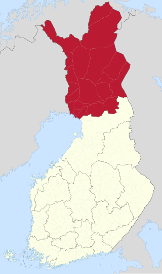
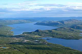
Muonio (previously called Muonionniska, Northern Sami : Muoná) is a municipality of Finland. The town is located in fell-region of far northern Finland above the Arctic Circle on the country's western border with Sweden, the Muonio River. It lies within the area of the former Lappi (Lapland) province in the Fell Lapland subregion. [4] The next closest Finnish municipalities are Enontekiö to the north, Kittilä on the east, and Kolari to the south. Southwest of the town, a road bridge crosses the Muonio River, across the river, in Sweden, lies the nearby hamlet of Muoniovaara ("Muonio hill") in northern Pajala Municipality in Norrbotten County.

Contents

The area has been occupied by humans for at least 10,000 years; their arrival is thought to have coincided with deglaciation at the end of the Younger Dryas. They likely arrived from the south or east, since the Scandinavian Mountains rise 2,100 metres on the west, and over 1,300 metres to the north - both form a significant barrier to migration. Remains of eight dwellings from the Middle Stone Age have been excavated on the shore of Lake Akajarvi (fifteen miles from the center of the present-day village). [5]

Prior to the historical period (c.1500 AD) archeological findings in the area are consistent with those known to be of Sámi peoples. Muonio (then called Muonionniska) first appears in written records in the mid-1500s in records of fishing-rights claims and disputes between Sámi indigenes and Finnish pioneer-hunters and fishermen. [6]

The municipality today has a population of 2,325 (31 December 2023) [2] and covers an area of 2,039.97 square kilometres (787.64 sq mi) of which 133.91 km2 (51.70 sq mi) is water. [1] The population density is 1.22 inhabitants per square kilometre (3.2/sq mi). The municipality is unilingually Finnish, unlike many towns on the Finland–Sweden border.

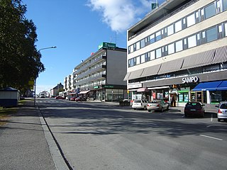
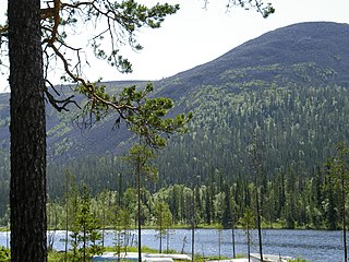
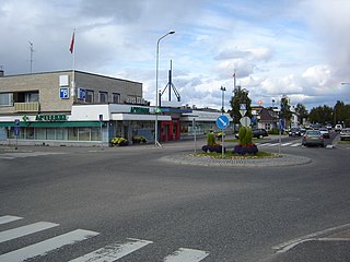
Muonio is good base for exploring the many things to do in the area; [7] it offers a variety of accommodations and commercial supply establishments and is on the E8 highway which goes north to Kilpisjärvi. [8] International air flights and train service terminate at Kittilä; local bus service connects to Muonio. Other busses will take you to Rovaniemi, Helsinki, or even to Tromsø, Norway. [9] Pallas-Yllästunturi National Park is nearby and offers year-round activities. [10]

Muonio is known as the municipality with the longest snow season in Finland. For that reason its vocational college has a top ski class that attracts aspiring cross-country ski champions from all over Finland. The "midnight sun" is above the horizon from 27 May to 17 July (52 days), and the period with continuous daylight is during this time. The period of continuous night, polar night, lasts from 10 December to 2 January (24 days).

Villages

The villages in Muonio include:

Politics

Results of the 2011 Finnish parliamentary election in Muonio:

Climate

Climate data for Muonio Kirkonkylä (1991-2020 normals)
MonthJanFebMarAprMayJunJulAugSepOctNovDecYear
Mean daily maximum °C (°F)−9.0
(15.8)
−8.5
(16.7)
−2.4
(27.7)
3.5
(38.3)
9.9
(49.8)
16.0
(60.8)
19.2
(66.6)
16.6
(61.9)
10.5
(50.9)
2.1
(35.8)
−4.1
(24.6)
−6.9
(19.6)
3.9
(39.0)
Daily mean °C (°F)−13.7
(7.3)
−13.2
(8.2)
−7.8
(18.0)
−1.4
(29.5)
5.1
(41.2)
11.2
(52.2)
14.3
(57.7)
11.8
(53.2)
6.4
(43.5)
−1.0
(30.2)
−7.4
(18.7)
−11.1
(12.0)
−0.6
(31.0)
Mean daily minimum °C (°F)−18.1
(−0.6)
−17.5
(0.5)
−13.1
(8.4)
−6.3
(20.7)
0.4
(32.7)
6.5
(43.7)
9.7
(49.5)
7.3
(45.1)
2.7
(36.9)
−4.0
(24.8)
−10.9
(12.4)
−15.3
(4.5)
−4.9
(23.2)
Average precipitation mm (inches)32
(1.3)
27
(1.1)
26
(1.0)
28
(1.1)
41
(1.6)
66
(2.6)
75
(3.0)
69
(2.7)
50
(2.0)
43
(1.7)
39
(1.5)
35
(1.4)
532
(20.9)
Source: FMI [11] [12]

See also

Related Research Articles

<span class="mw-page-title-main">Laponia (historical province)</span> Historical Swedish province or landscape

Laponia was a historical Swedish province, or landscape, in the north of Sweden. It evolved from Lappmarken. In 1809, Sweden ceded the eastern part, along with Finland, to the Russian Empire, which in effect created a Swedish Lapland and Finnish Lapland.

The 21 municipalities of the Lapland Region in Finland are divided on six sub-regions:

<span class="mw-page-title-main">Kittilä</span> Municipality in Lapland, Finland

Kittilä is a municipality of Finland and a popular holiday resort.

<span class="mw-page-title-main">Lapland (Finland)</span> Region of Finland

Lapland is the largest and northernmost region of Finland. The 21 municipalities in the region cooperate in a Regional Council. Lapland borders the Finnish region of North Ostrobothnia in the south. It also borders the Gulf of Bothnia, Norrbotten County in Sweden, Finnmark County and Troms County in Norway, and Murmansk Oblast and the Republic of Karelia in Russia. The topography of Lapland varies from vast mires and forests in the south to fells in the north. The Arctic Circle crosses Lapland, so polar phenomena such as the midnight sun and polar night can be viewed in this region.

<span class="mw-page-title-main">Enontekiö</span> Municipality in Lapland, Finland

Enontekiö is a municipality in the Finnish part of Lapland with approx. 1,800 inhabitants. It is situated in the outermost northwest of the country and occupies a large and very sparsely populated area of about 8,400 square kilometres (3,200 sq mi) between the Swedish and Norwegian border. Finland's highest point, the Halti fell, with a height of 1,324 metres (4,344 ft) above the mean sea level, is situated in the north of Enontekiö. The municipality shares borders with regions of Sweden and Norway that encompass the Scandinavian Mountains. The administrative centre of Enontekiö is the village of Hetta. About one fifth of the community's population are Sami people. Enontekiö's main industries are tourism and reindeer husbandry.

<span class="mw-page-title-main">Kemi</span> Town in Lapland, Finland

Kemi is a town and municipality of Finland. It is located very near the city of Tornio and the Swedish border. The distance to Oulu is 105 kilometres (65 mi) to the south and to Rovaniemi is 117 kilometres (73 mi) to the northeast. It was founded in 1869 by a decree of the Emperor Alexander II of Russia because of its proximity to a deepwater port.

<span class="mw-page-title-main">Tornio</span> Town in Lapland, Finland

Tornio is a city and municipality in Lapland, Finland. The city forms a cross-border twin city together with Haparanda on the Swedish side. The municipality covers an area of 1,348.83 square kilometres (520.79 sq mi), of which 161.59 km2 (62.39 sq mi) is water. The population density is 17.68 inhabitants per square kilometre (45.8/sq mi), with a total population of 21,018.

<span class="mw-page-title-main">Ylitornio</span> Municipality in Lapland, Finland

Ylitornio is a municipality of Finland.

<span class="mw-page-title-main">Inari, Finland</span> Municipality in Lapland, Finland

Inari is Finland's largest municipality by area, with four official languages, more than any other in the country. Its major sources of income are tourism, service industry, and cold climate testing. With the Siida museum in the village of Inari, it is a center of Sámi culture, widely known as the "capital of Sámi culture".

<span class="mw-page-title-main">Kolari</span> Municipality in Lapland, Finland

Kolari is a municipality of Finland at the Swedish border, which follows the Torne River, the longest free-flowing river in Europe.

<span class="mw-page-title-main">Kuusamo</span> Town and municipality in North Ostrobothnia, Finland

Kuusamo is a town and municipality in Finland. It is located in Koillismaa, the northeastern part of the Northern Ostrobothnia region. The municipality has a population of 15,019 and covers an area of 5,808.92 square kilometres (2,242.84 sq mi) of which 830.81 km2 (320.78 sq mi) is water. The population density is 3.02 inhabitants per square kilometre (7.8/sq mi).

<span class="mw-page-title-main">Sodankylä</span> Municipality in Lapland, Finland

Sodankylä is a municipality of Finland. It is located in the region of Lapland, and lies at the northern end of Highway 5 (E63) and along Highway 4 (E75). The Kitinen River flows near the center of Sodankylä. Its neighbouring municipalities are Inari, Kemijärvi, Kittilä, Pelkosenniemi, Rovaniemi, and Savukoski. The municipality has two official languages: Finnish and Northern Sami.

<span class="mw-page-title-main">Kilpisjärvi</span> Village in Lapland, Finland

Kilpisjärvi is a village in the municipality of Enontekiö, Lapland, Finland. It is located in Finland's northwestern "arm" near the northwesternmost point of Finland.

<span class="mw-page-title-main">Lapland (Sweden)</span> Historical province of Sweden

Lapland, also known by its Swedish name Lappland, is a province in northernmost Sweden. It borders the Swedish provinces of Jämtland, Ångermanland, Västerbotten, and Norrbotten, as well as Norway and Finland. Nearly a quarter of Sweden's land area is in Lappland.

<span class="mw-page-title-main">Pallas-Yllästunturi National Park</span> National park in Lapland region, Finland

Pallas-Yllästunturi National Park is Finland's third largest national park and it covers an area of 1,020 square kilometres. The national park is located in Western Lapland in the municipalities of Enontekiö, Kittilä, Kolari and Muonio. The landscape of Pallas-Yllästunturi National Park is dominated by a chain of fells stretching for approximately 100 km and the taiga forests in the boreal forest zone. In terms of visits, Pallas-Yllästunturi National Park is Finland's most popular national park. In 2019, the visitor counters recorded 561,200 visits.

<span class="mw-page-title-main">Karesuvanto</span> Place in Enontekiö, Finland

Karesuvanto or Kaaresuvanto is a village in Enontekiö municipality, located in Finnish Lapland, the largest and northernmost region in Finland. It is located on the Muonio River, which follows Finland's western border with Sweden.

<span class="mw-page-title-main">Hetta</span> Village in Lapland, Finland

Hetta is the main village in the municipality of Enontekiö in the north-west part of Finnish Lapland. It is also the municipality's administrative centre and the start or end point of the standard trekking / skiing route across the Pallas-Yllastunturi National Park.

Jerisjärvi is a medium-sized lake of Finland in Muonio and Kittilä. It belongs to Tornionjoki main catchment area in Lapland. in the southern side of the Pallas-Yllästunturi National Park.

<span class="mw-page-title-main">Pallastunturi</span> Group of fells in Lapland, Finland

Pallastunturi is a group of seven fells in the municipalities of Muonio and Enontekiö in Lapland, Finland. The highest peak is 809-metre (2,654 ft) Taivaskero, which is also highest peak of Pallas-Yllästunturi National Park and whole Lapland excluding Käsivarsi area.

<span class="mw-page-title-main">Hotel Pallas</span> Hotel in Muonio, Finland

Hotel Pallas is a wilderness hotel located in the Pallastunturi Ski Center in Muonio, Finland. The hotel was designed by architect Jouko Ylihannu and was opened in 1948.

References

  1. 1 2 "Area of Finnish Municipalities 1.1.2018" (PDF). National Land Survey of Finland. Retrieved 30 January 2018.
  2. 1 2 3 "Population growth biggest in nearly 70 years". Population structure. Statistics Finland. 26 April 2024. ISSN   1797-5395 . Retrieved 29 April 2024.
  3. "Population according to age (1-year) and sex by area and the regional division of each statistical reference year, 2003–2020". StatFin. Statistics Finland . Retrieved 2 May 2021.
  4. "New regional administration model abolishes provinces in 2010". Helsingin Sanomat International Edition. Sanoma Corporation. 31 December 2009. Archived from the original on 13 December 2011. Retrieved 1 January 2010.{{cite web}}: Check |archiveurl= value (help)
  5. Siv Rasmussen (January 2008). "Vellikaara Vettasia: Muonion ja Äkäslompolon alueen saamen historia (History of the Sámi of Muonio and the Äkäslompolo Region)" (PDF). Retrieved 12 August 2024.
  6. "Information about Muonio".
  7. Muonio Travel Guide
  8. Kilpisjärvi Travel Guide
  9. "Discover Muonio -". 25 May 2020.
  10. "Pallas-Yllästunturi National Park".
  11. "Lämpötilatilastot". Finnish Meteorological Institute . Retrieved 24 August 2023.
  12. "Sadetilastot". Finnish Meteorological Institute . Retrieved 24 August 2023.

Commons-logo.svg Media related to Muonio at Wikimedia Commons Wikivoyage-Logo-v3-icon.svg Muonio travel guide from Wikivoyage