Kemi

Last updated • 4 min readFrom Wikipedia, The Free Encyclopedia

Kemi
Giepma
Kiemâ
Ǩeeʹmm
Town
Kemin kaupunki
Kemi stad
Montage of Kemi 03.jpg
Clockwise, from top left: Kemi Railway Station, Kemi City Hall, Karihaara School, Café at the inner harbour, and Kemi Church
Kemi.vaakuna.svg
Nickname: 
Monaco of Finland
Kemi sijainti Suomi.svg
Location of Kemi in Finland
Coordinates: 65°44′10″N024°33′49″E / 65.73611°N 24.56361°E / 65.73611; 24.56361
CountryFlag of Finland.svg  Finland
Region Lapland
Sub-region Kemi–Tornio
Charter 1869
Government
   Town manager Matti Ruotsalainen
Area
 (2018-01-01) [1]
  Total
747.28 km2 (288.53 sq mi)
  Land95.38 km2 (36.83 sq mi)
  Water652.1 km2 (251.8 sq mi)
  Rank 300th largest in Finland
Elevation
4 m (13 ft)
Population
 (2024-10-31) [2]
  Total
19,424
  Rank 60th largest in Finland
  Density203.65/km2 (527.5/sq mi)
Population by native language
[2]
   Finnish 93.8% (official)
   Swedish 0.2%
  Others6%
Population by age
[3]
  0 to 1414.4%
  15 to 6457.2%
  65 or older28.4%
Time zone UTC+02:00 (EET)
  Summer (DST) UTC+03:00 (EEST)
Postal code
94100
Website www.kemi.fi/en/

Kemi (Finnish: [ˈkemi] ; Northern Sami : Giepma [ˈkie̯pma] ; Inari Sami : Kiemâ; Skolt Sami : Ǩeeʹmm) is a town and municipality of Finland. It is located very near the city of Tornio and the Swedish border. The distance to Oulu is 105 kilometres (65 mi) to the south and to Rovaniemi is 117 kilometres (73 mi) to the northeast. It was founded in 1869 by a decree of the Emperor Alexander II of Russia because of its proximity to a deepwater port.

Contents

The town has a population of 19,424 (31 October 2024) [2] and covers an area of 747.28 km2 (288.53 sq mi) of which 652.1 square kilometers (251.8 sq mi) are water. [1] The population density is 203.65 inhabitants per square kilometre (527.5/sq mi).

History

World War II hostage crisis

During World War II, after Finland signed the Moscow Armistice and found itself involved in the Lapland War against its former German ally, German forces at the beginning of October 1944 captured 132 Finnish civilian hostages in Kemi (as well as 130 in Rovaniemi) and threatened to kill them unless the Finnish army released the German POWs captured in the Battle of Tornio. However, Finland refused to comply and threatened to retaliate by killing the German POWs. The hostages were released unharmed on October 11, 1944, near Rovaniemi.[ citation needed ]

Geography

Kemi is situated on the Bothnian Bay, at the mouth of the river Kemijoki, and it is part of the Lapland region.

Climate

The climate type of Kemi is a typical subarctic climate (Köppen Dfc). It is characterized by long, cold winters and warm, short summers; but because it is on the coast of the Gulf of Bothnia, the characteristics of its continental climate are not as pronounced as inland areas.

Climate data for Kemi (Kemi-Tornio Airport, 1991–2020 normals, records 1959–present)
MonthJanFebMarAprMayJunJulAugSepOctNovDecYear
Record high °C (°F)8.8
(47.8)
7.7
(45.9)
9.6
(49.3)
18.3
(64.9)
28.1
(82.6)
31.4
(88.5)
32.9
(91.2)
29.2
(84.6)
23.7
(74.7)
15.9
(60.6)
10.0
(50.0)
6.8
(44.2)
32.9
(91.2)
Mean maximum °C (°F)2.8
(37.0)
3.1
(37.6)
5.9
(42.6)
11.8
(53.2)
21.1
(70.0)
24.7
(76.5)
26.5
(79.7)
24.3
(75.7)
18.1
(64.6)
11.4
(52.5)
6.2
(43.2)
3.5
(38.3)
27.3
(81.1)
Mean daily maximum °C (°F)−5.7
(21.7)
−5.7
(21.7)
−0.9
(30.4)
4.4
(39.9)
11.4
(52.5)
17.2
(63.0)
20.6
(69.1)
18.0
(64.4)
12.6
(54.7)
5.2
(41.4)
0.3
(32.5)
−3.0
(26.6)
6.2
(43.2)
Daily mean °C (°F)−9.6
(14.7)
−9.7
(14.5)
−5.4
(22.3)
0.4
(32.7)
6.8
(44.2)
12.8
(55.0)
16.0
(60.8)
13.9
(57.0)
8.8
(47.8)
2.4
(36.3)
−2.6
(27.3)
−6.6
(20.1)
2.3
(36.1)
Mean daily minimum °C (°F)−14.1
(6.6)
−14.4
(6.1)
−10.3
(13.5)
−3.9
(25.0)
1.5
(34.7)
7.3
(45.1)
11.0
(51.8)
9.1
(48.4)
4.7
(40.5)
−1.0
(30.2)
−5.5
(22.1)
−10.4
(13.3)
−2.2
(28.1)
Mean minimum °C (°F)−28.1
(−18.6)
−28.1
(−18.6)
−23.2
(−9.8)
−13.7
(7.3)
−4.4
(24.1)
0.8
(33.4)
4.6
(40.3)
1.0
(33.8)
−3.3
(26.1)
−11.8
(10.8)
−16.8
(1.8)
−23.6
(−10.5)
−30.5
(−22.9)
Record low °C (°F)−37.1
(−34.8)
−43.2
(−45.8)
−34.0
(−29.2)
−25.4
(−13.7)
−9.3
(15.3)
−3.4
(25.9)
1.4
(34.5)
−2.2
(28.0)
−9.8
(14.4)
−24.8
(−12.6)
−31.3
(−24.3)
−36.7
(−34.1)
−43.2
(−45.8)
Average precipitation mm (inches)32.3
(1.27)
25.8
(1.02)
28.7
(1.13)
26.4
(1.04)
30.3
(1.19)
39.2
(1.54)
52.2
(2.06)
63.4
(2.50)
58.1
(2.29)
59.9
(2.36)
44.8
(1.76)
33.0
(1.30)
494.1
(19.46)
Average precipitation days (≥ 0.1 mm)252221161415151617212424230
Average relative humidity (%)88878172636369768288929079
Source: FMI [a]
Climate data for Kemi Ajos (1991–2020 normals, records 1993–present)
MonthJanFebMarAprMayJunJulAugSepOctNovDecYear
Record high °C (°F)4.7
(40.5)
5.4
(41.7)
7.1
(44.8)
16.5
(61.7)
27.4
(81.3)
28.7
(83.7)
31.2
(88.2)
30.1
(86.2)
24.0
(75.2)
16.0
(60.8)
8.5
(47.3)
5.3
(41.5)
31.2
(88.2)
Mean daily maximum °C (°F)−5.5
(22.1)
−5.9
(21.4)
−1.9
(28.6)
3.3
(37.9)
9.5
(49.1)
15.9
(60.6)
19.7
(67.5)
17.6
(63.7)
12.5
(54.5)
5.9
(42.6)
1.0
(33.8)
−2.7
(27.1)
5.8
(42.4)
Daily mean °C (°F)−8.6
(16.5)
−9.2
(15.4)
−5.6
(21.9)
−0.3
(31.5)
5.7
(42.3)
12.7
(54.9)
16.4
(61.5)
14.9
(58.8)
10.1
(50.2)
3.8
(38.8)
−1.3
(29.7)
−5.1
(22.8)
2.8
(37.0)
Mean daily minimum °C (°F)−12.5
(9.5)
−13.2
(8.2)
−9.8
(14.4)
−3.5
(25.7)
2.8
(37.0)
9.9
(49.8)
13.8
(56.8)
12.5
(54.5)
7.9
(46.2)
2.1
(35.8)
−3.3
(26.1)
−8.3
(17.1)
−0.1
(31.8)
Record low °C (°F)−37.1
(−34.8)
−33.8
(−28.8)
−28.5
(−19.3)
−19.6
(−3.3)
−9.3
(15.3)
1.9
(35.4)
6.2
(43.2)
3.3
(37.9)
−1.8
(28.8)
−12.9
(8.8)
−23.3
(−9.9)
−30.2
(−22.4)
−37.1
(−34.8)
Source 1: https://www.ilmatieteenlaitos.fi/ilmastollinen-vertailukausi
Source 2: https://kilotavu.com/asema-taulukko.php?asema=101846

Note

  1. Climatological normals for Finland 19912020, [4] Record highs and lows, [5] Precipitation 19611990, [6] Precipitation days [7]

Economy

Valtakatu street seen from Kemi City Hall. Kemi City Hall view 4.jpg
Valtakatu street seen from Kemi City Hall.

The main economic activity in Kemi is centered on two large paper and woodpulp mills and on the only chromium mine in Europe (which supplies the Outokumpu ferrochrome plant in Tornio).

In April 2007, the city of Kemi laid off all of its municipal workers for two weeks due to the failing economy of the city. Spiraling specialist healthcare costs and a fleeing industry tax base are stated as the cause for the firing. [8] These are the most drastic temporary dismissals to take place in Finland since 2000.

Sights

Kemi SnowCastle LumiLinna.jpg
Kemi SnowCastle

Kemi has a claim to fame as the home of the world's largest snow castle [9] (reconstructed every year to a different design). The SnowCastle of Kemi is usually built in the inner harbor of the city.

A model of The Crown of Finland (the original was never made for the King of Finland) is kept in the town's gemstone gallery. It also houses replicas of the Imperial State Crown of Great Britain, the scepter of the Czar of Russia, the Orbs of Denmark, and the diamond necklace of Marie Antoinette, among other items.

Additional attractions include:

Culture

Kemi is the hometown of the power metal band Sonata Arctica.[ citation needed ]

Politics

Results of the 2019 Finnish parliamentary election in Kemi: [10]

Town manager

Town managerTerm
Olli Nylander 1930-1956
Risto Hölttä 1956-1966
Taisto Jokelainen 1967-1980
Juhani Leino 1980-2000
Kalervo Ukkola 2000-2005
Ossi Repo 2006-2012
Tero Nissinen 2012-2021
Matti Ruotsalainen 2021-

Transportation

The Karihaaranvayla street and bridge over the National road 4 in Kemi Karihaaranvayla Kemi 20150228.jpg
The Karihaaranväylä street and bridge over the National road 4 in Kemi

Kemi railway station is an intermediate station on the railway between Lapland and Helsinki. It is operated by VR. The junction of the Kolari and Rovaniemi lines lies to the north of Kemi station.

Finnish national road 4 and European routes E8 and E75 run through the town.

Kemi-Tornio Airport is located 4.5 kilometers (2.8 mi) north of Kemi city center.

The Port of Kemi is a cargo port handling containerised and bulk cargo as well as oil and petrochemical products. [11]

Education

A polytechnic university of applied sciences is situated in Kemi.

Notable residents

International relations

Twin towns – sister cities

Kemi is twinned with:

See also

Related Research Articles

<span class="mw-page-title-main">Helsinki</span> Capital and most populous city of Finland

Helsinki is the capital and most populous city in Finland. It is on the shore of the Gulf of Finland and is the seat of southern Finland's Uusimaa region. About 684,000 people live in the municipality, with 1.3 million in the capital region and 1.6 million in the metropolitan area. As the most populous urban area in Finland, it is the country's most significant centre for politics, education, finance, culture, and research. Helsinki is 80 kilometres (50 mi) north of Tallinn, Estonia, 400 kilometres (250 mi) east of Stockholm, Sweden, and 300 kilometres (190 mi) west of Saint Petersburg, Russia. Helsinki has significant historical connections with these three cities.

<span class="mw-page-title-main">Rovaniemi</span> Municipality in Lapland, Finland

Rovaniemi is a city in Finland and the regional capital of Lapland. It is located near the Arctic Circle in the northern interior of the country. The population of Rovaniemi is approximately 66,000, while the sub-region has a population of approximately 69,000. It is the 17th most populous municipality in Finland, and the 12th most populous urban area in the country. Rovaniemi is also the largest city in Europe by land area.

<span class="mw-page-title-main">Lapland (Finland)</span> Region of Finland

Lapland is the largest and northernmost region of Finland. The 21 municipalities in the region cooperate in a Regional Council. Lapland borders the Finnish region of North Ostrobothnia in the south. It also borders the Gulf of Bothnia, Norrbotten County in Sweden, Finnmark County and Troms County in Norway, and Murmansk Oblast and the Republic of Karelia in Russia. The topography of Lapland varies from vast mires and forests in the south to fells in the north. The Arctic Circle crosses Lapland, so polar phenomena such as the midnight sun and polar night can be viewed in this region.

<span class="mw-page-title-main">Tornio</span> Town in Lapland, Finland

Tornio is a city and municipality in Lapland, Finland. The city forms a cross-border twin city together with Haparanda on the Swedish side. The municipality covers an area of 1,348.83 square kilometres (520.79 sq mi), of which 161.59 km2 (62.39 sq mi) is water. The population density is 17.66 inhabitants per square kilometre (45.7/sq mi), with a total population of 20,989.

<span class="mw-page-title-main">Kemijärvi</span> Town in Lapland, Finland

Kemijärvi is a town and municipality of Finland. It is located in the sub-region of Eastern Lapland.

<span class="mw-page-title-main">Keminmaa</span> Municipality in Lapland, Finland

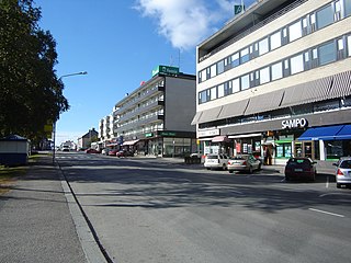
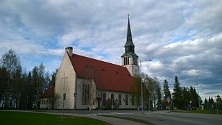
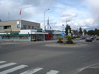
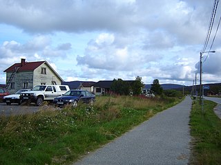
Keminmaa is a municipality of Finland. It is located near the towns of Kemi and Tornio in the Lapland region.

<span class="mw-page-title-main">Muonio</span> Municipality in Lapland, Finland

Muonio is a municipality of Finland. The town is located in fell-region of far northern Finland above the Arctic Circle on the country's western border with Sweden, the Muonio River. It lies within the area of the former Lappi (Lapland) province in the Fell Lapland subregion. The next closest Finnish municipalities are Enontekiö to the north, Kittilä on the east, and Kolari to the south. Southwest of the town, a road bridge crosses the Muonio River, across the river, in Sweden, lies the nearby hamlet of Muoniovaara in northern Pajala Municipality in Norrbotten County.

<span class="mw-page-title-main">Pelkosenniemi</span> Municipality in Lapland, Finland

Pelkosenniemi is a municipality of Finland. It is located in the province of Lapland. The municipality has a population of 916 (31 October 2024), which make it the smallest municipality in Lapland in terms of population. It covers an area of 1,881.58 square kilometres (726.48 sq mi) of which 45.4 km2 (17.5 sq mi) is water. The population density is 0.5 inhabitants per square kilometre (1.3/sq mi). Neighbour municipalities are Kemijärvi, Rovaniemi, Salla, Savukoski and Sodankylä.

<span class="mw-page-title-main">Kuusamo</span> Town and municipality in North Ostrobothnia, Finland

Kuusamo is a town and municipality in Finland. It is located in Koillismaa, the northeastern part of the Northern Ostrobothnia region. The municipality has a population of 14,783 and covers an area of 5,808.92 square kilometres (2,242.84 sq mi) of which 830.81 km2 (320.78 sq mi) is water. The population density is 2.97 inhabitants per square kilometre (7.7/sq mi).

<span class="mw-page-title-main">Sodankylä</span> Municipality in Lapland, Finland

Sodankylä is a municipality of Finland. It is located in the region of Lapland, and lies at the northern end of Highway 5 (E63) and along Highway 4 (E75). The Kitinen River flows near the center of Sodankylä. Its neighbouring municipalities are Inari, Kemijärvi, Kittilä, Pelkosenniemi, Rovaniemi, and Savukoski. The municipality has two official languages: Finnish and Northern Sami.

<span class="mw-page-title-main">Nuorgam</span> Village in Lapland, Finland

Nuorgam is a village in the Utsjoki municipality in the region of Lapland, Finland. It has approximately 200 inhabitants. It is the northernmost point of Finland and the northernmost point of the European Union. It is situated on the Deatnu river, which is very popular for salmon fishing. Nuorgam is located near the villages of Utsjoki and Tana bru. The nearest cities are Murmansk, Rovaniemi, Hammerfest, Alta and Tromsø.

<span class="mw-page-title-main">Battle of Tornio</span> 1944 Finnish-German battle

The Battle of Tornio was the first major engagement between Nazi Germany and Finland in the Lapland War; although hostilities had already begun elsewhere.

<span class="mw-page-title-main">Battle of Rovaniemi</span> Battle in the Lapland War

The Battle of Rovaniemi was an event during the 1944 Lapland War. The actual fighting between the components of the Finnish Armoured Division and Finnish 3rd Division against the troops of the German Twentieth Mountain Army took place at the vicinity of the town of Rovaniemi. The notoriety of the encounter derives from the near-total destruction of the town.

<span class="mw-page-title-main">Bothnian Bay</span> Bay in the northern Bothnian Sea

The Bothnian Bay or Bay of Bothnia is the northernmost part of the Gulf of Bothnia, which is in turn the northern part of the Baltic Sea. The land holding the bay is still rising after the weight of ice-age glaciers has been removed, and within 2,000 years the bay will be a large freshwater lake since its link to the south Kvarken is mostly less than 20 metres (66 ft) deep. The bay today is fed by several large rivers, and is relatively unaffected by tides, so has low salinity. It freezes over each year for up to six months. Compared to other parts of the Baltic, it has little plant or animal life.

<span class="mw-page-title-main">Kemi railway station</span> Railway station in Kemi, Finland

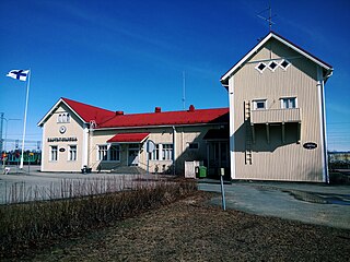
Kemi railway station is located in the town of Kemi in the Lapland Region of Finland. It is operated by VR. The distance to the Helsinki Central railway station, via Haapamäki and Oulu stations is 858.3 kilometres.

<span class="mw-page-title-main">Lappmarken</span> Old Swedish name for a region in northern Sweden and Finland

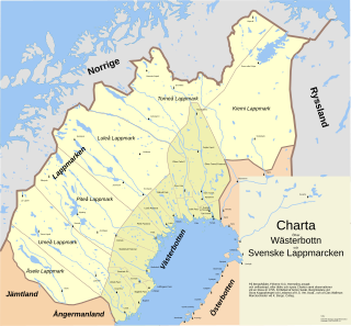
Lappmarken was an earlier Swedish name for the northern part of the old Kingdom of Sweden inhabited by the Sami people. In addition to the present-day Swedish Lapland, it also covered Västerbotten, Jämtland and Härjedalen, as well as the Finnish Lapland. As a name, it is related to Finnmark, an old Norwegian name for the Sami area. "Finn" and "Lapp" are mutually exchangeable old names for the Sami people, although the latter is sometimes deemed offensive.

<span class="mw-page-title-main">Lapland War</span> 1944–1945 war between Finland and Germany

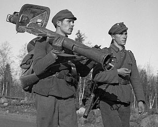
During World War II, the Lapland War saw fighting between Finland and Nazi Germany – effectively from September to November 1944 – in Finland's northernmost region, Lapland. Though the Finns and the Germans had been fighting together against the Soviet Union since 1941 during the Continuation War (1941–1944), peace negotiations between the Finnish government and the Allies of World War II had been conducted intermittently during 1943–1944, but no agreement had been reached. The Moscow Armistice, signed on 19 September 1944, demanded that Finland break diplomatic ties with Germany and expel or disarm any German soldiers remaining in Finland.

Lapland University of Applied Sciences, in short Lapland UAS, is a Finnish polytechnic university located in the cities of Kemi, Tornio and Rovaniemi. It was founded on January 1, 2014 as a merger between Rovaniemi University of Applied Sciences and Kemi-Tornio University of Applied Sciences. The merger carried over all the features of the previous organizations in an expanded organization form.

<span class="mw-page-title-main">Ensio Seppänen</span> Finnish sculptor and professor

Kauko Ensio Seppänen was a Finnish sculptor, professor (1978) and sculpture pioneer in Lapland. He created a total of 127 public sculptures. On the occasion of his crafting more public sculptures than any other artist in Finland, the 7 September 1984 issue of Finnish newspaper Helsingin Sanomat bore the headline "Sculptor Ensio Seppänen, is a Finnish record man".

<span class="mw-page-title-main">Arctic Railway</span> Planned railway connection from Northern Finland to the Arctic Ocean

The Arctic Railway is a planned railway line linking the Norwegian Arctic port of Kirkenes with the Finnish railway network.

References

  1. 1 2 "Area of Finnish Municipalities 1.1.2018" (PDF). National Land Survey of Finland. Retrieved 30 January 2018.
  2. 1 2 3 "Finland's preliminary population figure was 5,635,560 at the end of October 2024". Population structure. Statistics Finland. 19 November 2024. ISSN   1797-5395 . Retrieved 22 November 2024.
  3. "Population according to age (1-year) and sex by area and the regional division of each statistical reference year, 2003–2020". StatFin. Statistics Finland . Retrieved 2 May 2021.
  4. "FMI normals 1991-2020" (in Finnish). fmi.fi. Retrieved 11 April 2023.
  5. "FMI normals 1991-2020" (in Finnish). FMI. Retrieved 11 April 2023.
  6. "FMI normals 1991-2020" (in Finnish). FMI. Retrieved 11 April 2023.
  7. "Weatherbase: Historical Weather for Kemi, Finland". Weatherbase. 2013. Retrieved on April 18, 2013.
  8. "Northern city of Kemi to lay off all municipal workers for two weeks". Helsingin Sanomat – International Edition. Helsinki: Helsingin Sanomat Oy. 24 April 2007. Retrieved 7 January 2009.
  9. "Pictures of the day: 4 February 2011". The Telegraph. 4 February 2011. Retrieved 25 March 2018.
  10. "Eduskuntavaalit 2019, Kemi". Oikeusministerö - Tieto- ja tulospalvelu. 23 April 2019. Retrieved 27 April 2019.
  11. "Port of Kemi". PortOfKemi.fi. Retrieved 3 October 2020.
  12. Bozsoki, Agnes. "Partnervárosok Névsora Partner és Testvérvárosok Névsora" [Partner and Twin Cities List]. City of Székesfehérvár (in Hungarian). Archived from the original on 8 December 2012. Retrieved 5 August 2013.