Imatra

Last updated
Imatra
Town
Imatran kaupunki
Imatra stad
Imatrankoski Valtionhotelli ilma.jpg
Imatran Valtionhotelli
Imatra.vaakuna.svg
Imatra sijainti Suomi.svg
Coordinates: 61°11′N028°46′E / 61.183°N 28.767°E / 61.183; 28.767
CountryFlag of Finland.svg  Finland
Region Etela-Karjala.vaakuna.svg South Karelia
Sub-region Imatra sub-region
Charter 1948
Government
   Town manager Matias Hildén
Area
 (2018-01-01) [1]
  Total191.28 km2 (73.85 sq mi)
  Land154.99 km2 (59.84 sq mi)
  Water36.29 km2 (14.01 sq mi)
  Rank 274th largest in Finland
Population
 (2023-12-31) [2]
  Total24,919
  Rank 41st largest in Finland
  Density160.78/km2 (416.4/sq mi)
Population by native language
[3]
   Finnish 91.3% (official)
   Swedish 0.1%
  Others8.6%
Population by age
[4]
  0 to 1412.1%
  15 to 6456.8%
  65 or older31.2%
Time zone UTC+02:00 (EET)
  Summer (DST) UTC+03:00 (EEST)
Climate Dfc
Website www.imatra.fi/en/

Imatra is a town in Finland, located in the southeastern interior of the country. Imatra is located in the region of South Karelia, on Lake Saimaa, the River Vuoksi. The population of Imatra is approximately 25,000, while the sub-region has a population of approximately 37,000. It is the 41st most populous municipality in Finland.

Contents

Imatra lies on the border with Russia. On the other side of the border, seven kilometres (4.3 mi) away from the centre of Imatra, lies the Russian town of Svetogorsk. The city of St. Petersburg is situated 210 km (130 mi) to the southeast, the Finnish capital Helsinki is 230 km (140 mi) away and Lappeenranta, the nearest Finnish town, is 37 km (23 mi) away.

The main employers are the pulp and paper manufacturer Stora Enso Oyj, the town of Imatra, the engineering steel manufacturer Ovako Bar Oy Ab and the Finnish Border Guard. As of October 2003, the total number of employees was 12,423. [5] As of December 2004, 1,868 people were employed by the City of Imatra. The town's nicknames include Imis, Ibiza and Nahkalippis City (leather baseball cap city). Due to its location close to the border, Russian tourists are a common sight in the town, and Russian tourism is a boon to the local economy. Most people shop in Imatra, and Imatra's tax-free sales are the third largest among Finnish cities (only Helsinki and Lappeenranta are ahead). [6]

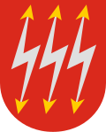
The name of Imatra is thought to derive from a pre-Finno-Ugric language. The lightning symbols on Imatra's coat of arms refer to the power plants that were built in the early 1920s at the Tainionskoski and Imatrankoski rapids. The coat of arms was designed by Olof Eriksson  [ fi ] and approved by the Imatra Town Council on 9 August 1950. The Ministry of the Interior approved the coat of arms for use on 25 October of the same year. [7] [8]
History

An Art Nouveau or Jugend style castle, currently known as Imatran Valtionhotelli (Imatra State Hotel), was built near the rapids in 1903 as a hotel for tourists from the Russian Imperial capital Saint Petersburg.

During the Continuation War, Carl Gustaf Emil Mannerheim met with Adolf Hitler in secrecy near the town for the former's 75th birthday.

Imatra was founded in 1948 on the territory of three municipalities – Jääski, Ruokolahti and Joutseno. Finland ceded 9% of its territory to the Soviet Union after the Winter War. Jääski lost 85% of its territory and it was decided that a new municipality, Imatra, should be established on the remaining 15% of Jääski and some areas of Ruokolahti and Joutseno. This is why the Imatra coat of arms has three flashes – in honour of those previous municipalities that granted areas to it. It gained its municipal charter in 1971.

Sport

PaSa Bandy is a bandy club in Imatra.

The men's pesäpallo club Imatran Pallo-Veikot competes in the Superpesis national league, playing at Ukonniemi Stadium.

Imatra is the birthplace of National Hockey League players Jussi Markkanen and Petteri Nokelainen.

In motorsport history, Imatra is best known for its road races (former TT-race) from 1963 to 1986. From 1962 to 1982 it was the home of the Finnish motorcycle Grand Prix. Racing on the Imatra road circuit ended after fatal accident during the 1986 European Championship event. [9] Racing resumed in 2016 as an International Road Racing Championship event.

There is an annual indoor rowing race at Imatra, which attracts competitors from across Finland. [10]

Culture

The Black & White Theatre has produced more than 20 performances, the movie "Murderer" and organized from 2004 Black & White Theatre Festival in Imatra. More information https://blackandwhitetheatre.fi/.

Transport

National Road 6 Vt6 Imatra.JPG
National Road 6

The national road 6, running from Koskenkylä in Loviisa to Kajaani via Kouvola, Lappeenranta, and Joensuu passes through Imatra. Also in Imatra is a crossing point over the Russian border, which is also the ending point of primary road 62 from Mikkeli.

The Kouvola–Joensuu railway passes through Imatra, and the Imatra railway station serves both passenger and freight transport. From the rail yard of this station is a fork onto the railway towards Kamennogorsk via Vyborg. The planning of the initiation of regular international passenger traffic between Imatra and Saint Petersburg has stopped due to Russia's war against Ukraine. [11]

The closest airport to Imatra is the Lappeenranta Airport, which is used by Ryanair on several routes as well as irregular passenger flights to the Canary Islands and cargo flights to Russia. The Immola Airfield is also present, serving the Finnish Border Guard as well as hobbyist aviation activities.

Notable people

International relations

Twin towns:


Sister cities:


Co-operation cities:

See also

Related Research Articles

<span class="mw-page-title-main">Karelian Isthmus</span> Isthmus in North-Western Russia

The Karelian Isthmus is the approximately 45–110-kilometre-wide (30–70 mi) stretch of land situated between the Gulf of Finland and Lake Ladoga in northwestern Russia, to the north of the River Neva. Its northwestern boundary is a line from the Bay of Vyborg to the westernmost point of Lake Ladoga, Pekonlahti. If the Karelian Isthmus is defined as the entire territory of present-day Saint Petersburg and Leningrad Oblast to the north of the Neva and also a tiny part of the Republic of Karelia, the area of the isthmus is about 15,000 km2 (5,800 sq mi).

<span class="mw-page-title-main">Southern Finland Province</span> Place in Finland

Southern Finland was a province of Finland from 1997 to 2009. It bordered the provinces of Western Finland and Eastern Finland. It also bordered the Gulf of Finland and Russia.

<span class="mw-page-title-main">Lappeenranta</span> City in South Karelia, Finland

Lappeenranta is a city in Finland and the regional capital of South Karelia. It is located in the southeastern interior of the country and in the Finnish Lakeland. The population of Lappeenranta is approximately 73,000, while the sub-region has a population of approximately 88,000. It is the 13th most populous municipality in Finland, and the 11th most populous urban area in the country.

<span class="mw-page-title-main">Saimaa</span> Largest lake in Finland and the fourth largest in Europe

Saimaa is a lake located in the Finnish Lakeland area in southeastern Finland. With a surface area of approximately 4,279 square kilometres (1,652 sq mi), it is the largest lake in Finland, and the fourth-largest natural freshwater lake in Europe.

<span class="mw-page-title-main">Joensuu</span> City in North Karelia, Finland

Joensuu is a city in Finland and the regional capital of North Karelia. It is located in the eastern interior of the country and in the Finnish Lakeland. The population of Joensuu is approximately 78,000, while the sub-region has a population of approximately 127,000. It is the 12th most populous municipality in Finland, and the ninth most populous urban area in the country.

The former Province of Southern Finland in Finland was divided into six regions, 16 sub-regions, and 88 municipalities.

<span class="mw-page-title-main">South Karelia</span> Region of Finland

South Karelia is a region of Finland. It borders the regions of Kymenlaakso, South Savo and North Karelia, as well as Russia.

<span class="mw-page-title-main">Karelia</span> Area of northern Europe

Karelia is an area in Northern Europe of historical significance for Russia, Finland, and Sweden. It is currently divided between northwestern Russia and Finland.

<span class="mw-page-title-main">SaiPa</span> Ice hockey club from Lappeenranta, Finland

Saimaan Pallo (SaiPa) is an ice hockey team in the Finnish Liiga. They play their home games at Kisapuisto in Lappeenranta, Finland. SaiPa has many nicknames, such as "The Sputniks", "Sputnik", "Miracle of the East" and "Eastern Giant."

<span class="mw-page-title-main">Joutseno</span> Former municipality in Southern Finland Province, Finland

Joutseno is a former town and municipality of Finland. It is located in the province of Southern Finland and is part of the South Karelia region.

<span class="mw-page-title-main">Parikkala</span> Municipality in South Karelia, Finland

Parikkala is a municipality of Finland located in the province of Southern Finland and is part of the South Karelia region, 97 kilometres (60 mi) from Lappeenranta and 139 kilometres (86 mi) from Joensuu. The town center of Parikkala is about 10 kilometres (6.2 mi) from the Russian border. The municipality has a population of 4,366 and covers an area of 760.71 square kilometres (293.71 sq mi) of which 167.78 km2 (64.78 sq mi) is water. The population density is 7.38 inhabitants per square kilometre (19.1/sq mi).

<span class="mw-page-title-main">Svetogorsk</span> Town in Leningrad Oblast, Russia

Svetogorsk is an industrial town in Vyborgsky District of Leningrad Oblast, Russia, located on the Karelian Isthmus, on the Vuoksi River. It is located one kilometre (0.62 mi) from the border with Finland, five kilometres (3.1 mi) from the Finnish town of Imatra, and 207 kilometers (129 mi) from St. Petersburg. Population: 15,981 (2010 Census); 15,698 (2002 Census); 15,594 (1989 Soviet census).

<span class="mw-page-title-main">Viipuri–Joensuu railroad</span> Railway line in Finland

The old Karelian railroad between Viipuri and Joensuu was a 1,524 mm broad gauge line that used to link Joensuu, Sortavala, Hiitola, Antrea and Viipuri. Originally built in 1892-1894 by Finnish State Railways in the Grand Duchy of Finland, in the 1940s most of the railway up to Niirala was ceded by Finland to the Soviet Union in the Moscow Peace Treaty, Moscow Armistice and Paris Peace Treaty as a result of the Winter War and Continuation War. Now the track is located in Leningrad Oblast, Republic of Karelia and North Karelia. The Sortavala–Joensuu link across the border was abolished after the Continuation War, but was since restored and is currently in use for cargo traffic.

<span class="mw-page-title-main">Lesogorsky</span> Urban-type settlement in Leningrad Oblast, Russia

Lesogorsky is an urban locality in Vyborgsky District of Leningrad Oblast, located on the left bank of the Vuoksi River, on the Karelian Isthmus, near the Russia–Finland border, and a station of the Kamennogorsk–Svetogorsk–Imatra railway. Population: 3,273 (2010 Census); 3,004 (2002 Census); 3,744 (1989 Soviet census).

<span class="mw-page-title-main">Viipuri Province</span> Former Finnish province (1812 - 1945)

Viipuri Province was a historical province of Finland from 1812 to 1945.

<span class="mw-page-title-main">Kymi Province</span> Former province in Finland

The Kymi Province was a province of Finland from 1945 to 1997.

<span class="mw-page-title-main">Imatran Ketterä</span> Ice hockey team in Imatra

Imatran Ketterä is an ice hockey club based in Imatra, Finland. Ketterä plays in the Finnish second-tier league, Mestis, during the 2022–23 season.

<span class="mw-page-title-main">Joutseno railway station</span> Railway station in Lappeenranta, Finland

The Joutseno railway station is located in the town of Lappeenranta, Finland, in the district of Joutseno. It is located along the Kouvola–Joensuu railway, and its neighboring stations are Lappeenranta in the west and Imatra in the east.

<span class="mw-page-title-main">Imatra railway station</span> Railway station in Imatra, Finland

The Imatra railway station is located in the town of Imatra, Finland, in the district of Mansikkala. It is located along the Kouvola–Joensuu railway, and its neighboring stations are Joutseno in the west and Simpele in the east.

<span class="mw-page-title-main">Lappee</span> Former municipality in Kymi Province, Finland

Lappee is an old parish and a former municipality of Finland in the South Karelia region, originally in the Viipuri Province and after the Second World War, the Kymi Province. It was consolidated with Lappeenranta in 1967 together with Lauritsala.

References

  1. "Area of Finnish Municipalities 1.1.2018" (PDF). National Land Survey of Finland. Retrieved 30 January 2018.
  2. "Population growth biggest in nearly 70 years". Population structure. Statistics Finland. 2024-04-26. ISSN   1797-5395 . Retrieved 2024-04-29.
  3. "Population growth biggest in nearly 70 years". Population structure. Statistics Finland. 2024-04-26. ISSN   1797-5395 . Retrieved 2024-04-29.
  4. "Population according to age (1-year) and sex by area and the regional division of each statistical reference year, 2003–2020". StatFin. Statistics Finland . Retrieved 2 May 2021.
  5. "Imatra". Imatra. Retrieved 24 December 2017.
  6. Tiilikainen, Tenho: Tax free -kauppa käy kiivaana Archived 2016-10-13 at the Wayback Machine . Etelä-Saimaa , 9 December 2006. (in Finnish)
  7. Suomen kunnallisvaakunat (in Finnish). Suomen Kunnallisliitto. 1982. p. 123. ISBN   951-773-085-3.
  8. "Imatran vaakunan vahvistaminen". Digitaaliarkisto: Heraldica I, vaakunat (in Finnish). Kansallisarkisto. Retrieved July 26, 2022.
  9. "Imatra (Finland): love and death in a cold GP climate" (in Italian). Retrieved 2017-07-16.
  10. "Concept FinnRowing Oy Race Results" (in Finnish). 8 March 2020. Retrieved 8 March 2020.
  11. "Kannakselle uusi junarata - Venäjä turvaa Suomenlahden öljysatamien kuljetukset".