List of national parks of Norway

Last updated

Map of national parks in 2018 Norske nasjonalparker kart.jpg
Map of national parks in 2018
National parks (green), nature reserves (purple), geotope protection areas (orange) and bird sanctuaries of Svalbard Svalbard protected areas map with names.svg
National parks (green), nature reserves (purple), geotope protection areas (orange) and bird sanctuaries of Svalbard

Norway has 48 national parks, of which 41 are on the mainland and 7 on Svalbard. National parks in Norway are stricter than many other countries, and nearly all motorized vehicles are prohibited. The Right to roam applies, thus hiking, skiing and camping throughout the park are permitted, given that consideration to nature is taken. Roads, accommodation and national park centers are located outside the national parks. The parks are under the management of the Norwegian Environment Agency and the local county governor. [1]

Contents

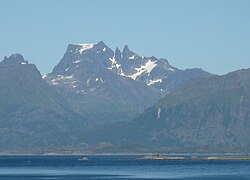
Ytre Hvaler is a marine park and all parks in Svalbard also contain marine areas. Sør-Spitsbergen is the largest park, covering an area of 13,286 km2 (5,130 sq mi), although only 5,141 km2 (1,985 sq mi) is land. [2] The newest national park assigned in Norway is Østmarka established in 2023. The largest park on the mainland is Hardangervidda, which covers an area of 3,422 km2 (1,321 sq mi). Gutulia is the smallest, covering 23 km2 (8.9 sq mi). [1]

Geography and history

At least 60% of Norway's area is mountainous, lakes or bogs (non-arable land, some of it is used as pastures); 37% is forest of various kinds; and only 3% arable land. It is estimated that between 1900 and 2003 areas more than 5 km from intense construction activity have decreased from 48% to 12% in Norway.

Until about one hundred years ago there was relatively little threat to ecosystems in Norway. The first initiatives to protect land were voiced in 1904, by Yngvar Nielsen, leader of the Norwegian Mountain Touring Association (DNT). The association continued to lobby cases in 1923 and 1938. The natural protection act of 1954 prepared a legal basis for establishing protection areas, and the two first national parks were established in 1962 and 1963. The act of 1954 also established Statens naturvernråd ("Governmental Natural protection council") as an advisory body for the government. The council presented a draft for further natural protecting in 1964, suggesting 16 national parks. These suggestions were approved by Stortinget. It took 25 years, until 1989, before 15 of their suggestions were fulfilled. The 16th suggestion became a naturreservat. The council presented another suggestion in 1986, [3] and this was approved by Stortinget in April 1993. Following this approval, a "second generation" of national parks, as well as expanding borders for the elder, were established from 2001.

The post-industrial era that started in the last 1960s saw areas being protected as national parks or other protected status as a means to regulate the construction of vacation homes, roads, fishing, hunting, and gathering plants. This trend has accelerated in the last 10 years. In addition to preserving rare plant and animal life, areas are protected to maintain reference points for environmental research, recreational resources for Norwegians, and as an inheritance for future generations. The Directorate for Nature Management maintains indicators for the health of nature in Norway, including such measures as biological diversity, erosion, signs of pollution.

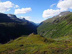
For the most part, national parks are open to hiking, cross-country skiing and camping. Most have a limited number of overnight cabins.

In addition to national parks, the Norwegian government has designated larger areas for protection. Included in these areas are 153 landscapes covering 14071 km2; 1,701 nature reserves covering 3,418 km2; 24 national parks covering 21,650 km2; 102 natural memorials, and 98 smaller protected areas. This accounts for 12.1% of Norway's mainland area.

The Norwegian government's goal is to increase this area over time to at least 15%. They have signalled an interest in preserving marine ecosystems, including the fjords of the western parts of Norway, and the archipelago southwest from Oslo.

Current

ImageNameCounty(s)Est.AreaDescriptionRef
Arctic sunset.jpg Anárjohka Finnmark 19751,390 km2 (540 sq mi) [1]
Auroral-band-over-Senja.jpg Ånderdalen Troms 1970134 km2 (52 sq mi) [1]
Skjaekerhatten.jpg Blåfjella–Skjækerfjella Nord-Trøndelag 20041,924 km2 (743 sq mi) [1]
P1000154Gamle Strynefjellsvegen.JPG Breheimen Oppland, Sogn og Fjordane 20091,671 km2 (645 sq mi)
VM.JPG Børgefjell Nord-Trøndelag, Nordland 19631,447 km2 (559 sq mi) [1]
Grimsdalen Panorama4718.jpg Dovre Oppland 2003289 km2 (112 sq mi) [1]
Dovrefjell.jpg Dovrefjell–Sunndalsfjella Møre og Romsdal, Oppland, Sør-Trøndelag 19741,693 km2 (654 sq mi) [1]
Faerder.jpg Færder Vestfold 2013350 km2 (140 sq mi) [1]
Engerdal Femunden.jpg Femundsmarka Hedmark, Sør-Trøndelag 1971573 km2 (221 sq mi) [1]
Lake Bondhus Norway 2862.jpg Folgefonna Hordaland 2005545 km2 (210 sq mi) [1]
Morsy1 (js).jpg Forlandet Svalbard 19734,647 km2 (1,794 sq mi)The park covers the uninhabited island of Prins Karls Forland and the surrounding waters. Forlandet is long and narrow with tall peaks, separated in two by the low Forlandsletta. It is the northernmost habitat of harbor seal and a nesting place for common guillemot. Wetland birds nest at Plankeholmane and Forlandsøyane, and the west coast is an overwintering site for seabirds. [2]
ForollhognaView.jpg Forollhogna Sør-Trøndelag, Hedmark 20011,062 km2 (410 sq mi) [1]
Fulufjellet nasjonalpark 007.JPG Fulufjellet Hedmark 201283 km2 (32 sq mi) [4]
Gutulia 08-0003.jpg Gutulia Hedmark 196823 km2 (8.9 sq mi) [1]
Eastern part of Hallingskarvet.jpg Hallingskarvet Buskerud, Hordaland 2006450 km2 (170 sq mi)
Hardangervidda 1986.jpg Hardangervidda Buskerud, Hordaland, Telemark 19813,422 km2 (1,321 sq mi) [1]
Indre Wijdefjorden National Park map.svg Indre Wijdefjorden Svalbard 20051,127 km2 (435 sq mi)Located in a steep fjord landscape in northern Spitsbergen, the park covers the inner part of Wijdefjorden—the longest fjord on Svalbard. On both sides of Wijdefjorden there is High Arctic steppe vegetation, dominated by grasses and extremely dry, basic earth. Along with vegetation found on nesting cliffs, it is the most exclusive flora in Svalbard. Of the larger fjords on Svalbard, Wijdefjorden is the least affected by humans. [2]
Jomfruland fyrvokterbolig.jpg Jomfruland Telemark 2016117 km2 (45 sq mi)
Briksdalsbreen.JPG Jostedalsbreen Sogn og Fjordane 19911,310 km2 (510 sq mi) [1]
Jotunheimen - view from Galdhopiggen.JPG Jotunheimen Oppland, Sogn og Fjordane 19801,151 km2 (444 sq mi) [1]
Sjurfjellet.jpg Junkerdal Nordland 2004682 km2 (263 sq mi) [1]
Utsikt mot Lahku nasjonalpark fra Skavldalen.jpg Làhku Nordland 2012188 km2 (73 sq mi)
Rossjokollbua.jpg Langsua Oppland 2011537 km2 (207 sq mi)
Lierne Nordland 2004333 km2 (129 sq mi) [1]
Lofotodden in Moskenes, Lofoten.jpg Lofotodden Nordland 201899 km2 (38 sq mi)
Lomsdalen.jpg Lomsdal–Visten Nordland 2009682 km2 (263 sq mi)
Moysalen 2.jpg Møysalen Nordland 200351 km2 (20 sq mi)
Daudmannsodden Lexfjellet IMG 2538.JPG Nordre Isfjorden Svalbard 20032,954 km2 (1,141 sq mi)Protecting the northern shore of Isfjorden on Spitsbergen, the park consists of a long shoreline with lush vegetation serving as breeding grounds for birds. The landscape varies from the barren and lunar-like to sandy plains and several meter-thick layers of deposits. [2]
Lilliehookbreen1.jpg Nordvest-Spitsbergen Svalbard 19739,914 km2 (3,828 sq mi)The northwestern part of Spitsbergen has the archipelago's most varied nature and features some of the most important cultural heritage sites from whaling and Arctic exploration, such as Smeerenburg and Virgohamna. The park is habitat for Arctic fox, reindeer and Arctic char. Moffen Nature Reserve and three bird sanctuaries (Guissezholmen, Moseøya and Skorpa) are important breeding grounds for birds, especially eider and geese. The warm springs of Bockfjorden give a unique local flora. [2]
Østmarka Oslo, Viken 202354 km2 (21 sq mi)
Ovre dividal anjajohka.jpg Øvre Dividal Troms 1971750 km2 (290 sq mi) [1]
Russia-Norway-Finland border.jpg Øvre Pasvik Finnmark 1970119 km2 (46 sq mi)Part of Pasvik–Inari Trilateral Park, the area is dominated by Siberian-like taiga consisting of old-growth Scots pine, shallow lakes and bog. The traditional Skolts area is still used for reindeer husbandry. The park located in Pasvikdalen and is a habitat for brown bear and moose. [5]
Arendal Tromoy Spornes b.JPG Raet Aust-Agder 2016607 km2 (234 sq mi)
Rago001.jpg Rago Nordland 1971171 km2 (66 sq mi) [1]
Karitinden.jpg Reinheimen Oppland, Møre og Romsdal 20061,969 km2 (760 sq mi)
Mollisfossen.jpg Reisa Troms 1986803 km2 (310 sq mi) [1]
Canyon in Rohkunborri National Park.jpg Rohkunborri Troms 2011571 km2 (220 sq mi)
Rondane haust.jpg Rondane Hedmark, Oppland 1962963 km2 (372 sq mi) [1]
Bjellavasstua.jpg Saltfjellet–Svartisen Nordland 19892,192 km2 (846 sq mi) [1]
Sassenfjorden.jpg Sassen–Bünsow Land Svalbard 20031,230 km2 (470 sq mi)The park covers Tempelfjorden, Bünsow Land and the vast fluvial plain of Sassendalen, located at the head of Isfjorden. Tempelfjorden is an important breeding ground for ringed seals, while Sassendalen and Gipsdalen are important breeding grounds for geese. Bünsow Land has the only European occurrence of polar mouse-ear ( Cerastium regelii ) and broad-sepal saxifrage ( Saxifraga platysepala ). [2]
Seiland2b.jpg Seiland Finnmark 2006316 km2 (122 sq mi)
Towards Sjunkhatten National Park.jpg Sjunkhatten Nordland 2010417 km2 (161 sq mi)
Skarvan 1.jpg Skarvan and Roltdalen Nord-Trøndelag, Sør-Trøndelag 2004441 km2 (170 sq mi) [1]
Polar Bear (js) 2.jpg Sør-Spitsbergen Svalbard 197313,286 km2 (5,130 sq mi)Covering the southern part of Spitsbergen (Wedel Jarlsberg Land, Torell Land and Sørkapp Land), the western part has jagged mountains while the eastern part is more rounded. Hornsund is an important migration area for polar bears, while four bird sanctuaries (Olsholmen, Isøyane, Dunøyane and Sørkapp) are vital nesting grounds for migratory seabirds. [2]
Stabbursfossen .JPG Stabbursdalen Finnmark 1970747 km2 (288 sq mi) [1]
Tundra1 (js).jpg Van Mijenfjorden Svalbard 20214,251 km2 (1,641 sq mi) [2]
E75-Varanger-Vardo-2012-07-07-16-30-03.jpg Varangerhalvøya Finnmark 20061,804 km2 (697 sq mi)
Ytre Hvaler, Landfasten vegetation.jpg Ytre Hvaler Østfold 2009354 km2 (137 sq mi)

Former

NameCountyEstablishedDisestablishedArea
(land, km2)
Area
(land, sq mi)
Replaced byRef
Gressåmoen Nord-Trøndelag 1970200418270 Blåfjella–Skjækerfjella
Ormtjernkampen Oppland 1968201193 Langsua [1]
Nordenskiöld Land Svalbard 200320211,362526 Van Mijenfjorden

Planned

National parkCountySize km2Outdoor recreational facilities providedStatus
Dåapma [6] Nord-Trøndelag 261Cancelled in 2013 after municipalities and reindeer herders pulled out of the process.
Muvrrešáhpi [7] Finnmark 291NoCancelled in 2015 after strong local opposition.
Preikestolen [8] Rogaland 215Marked trailsUnder consideration in 2019.
Treriksrøysa [9] Troms  ?Unmarked trails and a hut.Cancelled in 2015 after strong local opposition. Reproposed in 2019.
Tysfjord–Hellemobotn [10] Nordland ~1000Boat to HellemobotnCancelled in 2015 after strong local opposition.

There are also several national park proposals by many different parties: Solværøyene, Storheia; [11] Melkevatn–Hjertvatn–Børsvatn, Okstindan; [12] Frafjordheiene; [13] Oksøy-Ryvingen; [14] Setesdal Vesthei, Trollheimen, Lyngsalpan; [15] Mølen. [16]

Storheia has since been covered in a wind farm and would no longer qualify for protection as a national park, and parts of Melkevatn–Hjertvatn–Børsvatn were protected as a nature reserve rather than a national park.

After being tasked by the Ministry of Climate and Environment in 2018 to find areas that should be protected, in 2019 the Environment Agency made a number of suggestions for new national parks as well as expansions of existing ones, after looking through suggestions from the county governors. [17] In 2021, after meetings with the affected municipalities, they made a final list of suggestions for national parks that should get further consideration. The proposed new protections are: Sunnmørsalpane, Hornelen, Masfjordfjella and Øystesefjella. Additionally, they proposed some protected areas to be changed to national park: Lyngsalpan, Sylan, Trollheimen and Innerdalen, Ålfotbreen, Oksøy-Ryvingen, and Flekkefjord and Listastrendene. Many other proposals were cancelled due to local opposition: Kvænangsvidda-Nabar, Treriksrøysa, Preikestolen, Kvitladalen-Bjordalen, Viglesdalen; as well as some proposed changes of type of protection: Naustdal-Gjengedal and Setesdal Vesthei Ryfylkeheiane. [18]

Related Research Articles

<span class="mw-page-title-main">Møysalen National Park</span> National park in Nordland, Norway

Møysalen National Park is a national park located on the island of Hinnøya in Nordland county, Norway. The park was established in 2003 to preserve undisturbed coastal alpine landscape. The scenery is characterized by peaks jutting out of the ocean and fjords, the highest point is the 1,262-metre (4,140 ft) tall Møysalen mountain. The park mostly lies in Lødingen Municipality, but the far northern part crosses over into Sortland Municipality.

<span class="mw-page-title-main">Øvre Pasvik National Park</span> National park in Finnmark, Norway

Øvre Pasvik National Park is located in the southeastern part of the Pasvikdalen valley in southern Sør-Varanger Municipality in Finnmark county, Norway. Covering an area of 119 square kilometers (46 sq mi), the national park is dominated by Siberian-like taiga consisting of old-growth forests of Scots pine, shallow lakes and bog. Proposals for a national park in Øvre Pasvik were first launched in 1936, but the park was not created until 6 February 1970. It originally covered 66 square kilometers (25 sq mi), but was expanded on 29 August 2003. Øvre Pasvik is part of Pasvik–Inari Trilateral Park along with the adjacent Øvre Pasvik Landscape Protection Area, the joint Norwegian and Russian Pasvik Nature Reserve, and Finland's Vätsäri Wilderness Area.

<span class="mw-page-title-main">Anárjohka National Park</span>

Anárjohka National Park is a national park that lies in Karasjok and Kautokeino municipalities in Finnmark county, Norway. The park was opened in 1976 and is 1,409 square kilometres (544 sq mi) in area. It borders on Lemmenjoki National Park in Finland. A process to expand the national park by an additional 624.6 km2 (241 sq mi) was started in 2009, however it was cancelled in 2015 after local opposition. Anárjohka national park is located on the interior of the Finnmarksvidda plateau and it includes extensive birch woods, pine barrens, bogs, and lakes.

<span class="mw-page-title-main">Indre Wijdefjorden National Park</span> National park in northern Spitsbergen, Svalbard, Norway

Indre Wijdefjorden National Park is located in a steep fjord landscape in northern Spitsbergen in Svalbard, Norway. It covers the inner part of Wijdefjorden—the longest fjord on Svalbard. The national park was established on 9 September 2005 and covers 1,127 km2 (435 sq mi), of which 745 km2 (288 sq mi) is on land and 382 km2 (147 sq mi) is sea. The marine environment changes vastly from the mouth of the fjord, through a still, cold, water basin, becoming deeper before reaching the glacier Mittag-Lefflerbreen at the inner-most sections of the fjord.

<span class="mw-page-title-main">Ytre Hvaler National Park</span> National park in Norway

Ytre Hvaler National Park is a national park located within the municipalities of Hvaler and Fredrikstad in Østfold, Norway. The park was established on 26 June 2009 and was the first national marine park in the country of Norway.

<span class="mw-page-title-main">Lomsdal–Visten National Park</span> National park in Norway

Lomsdal–Visten National Park is a Norwegian national park that was established on 26 June 2009. The park consists of a total protected area of 1,102 square kilometres (425 sq mi). It is located in Nordland county, Norway, and covers parts of the municipalities of Brønnøy, Vevelstad, Grane, and Vefsn.

Blomstrandhamna Bird Sanctuary is a bird reserve at Svalbard, Norway, established in 1973. It includes the skerry in Blomstrandhamna in Haakon VII Land. The protected area covers a total of 580,000 square metres.

Boheman Bird Sanctuary is a bird reserve in Svalbard, Norway, established in 1973. It includes islands south of Bohemanflya in Oscar II Land. The protected area covers a total of 2,076,000 square metres.

Dunøyane Bird Sanctuary is a bird reserve in Svalbard, Norway, established in 1973. It includes islands west of Dunøysundet in Wedel Jarlsberg Land. The protected area covers a total of around 11.9 km2.

Gåsøyane Bird Sanctuary is a bird reserve at Svalbard, Norway, established in 1973. It includes Gåsøyane in Bünsow Land. The protected area covers a total area of around 2,400,000 square metres.

Guissezholmen Bird Sanctuary is a bird reserve at Svalbard, Norway, established in 1973. It includes islets at Kapp Guissez in Haakon VII Land. The protected area covers a total area of around 400,000 square metres.

Hermansen Island Bird Sanctuary is a bird reserve at Svalbard, Norway, established in 1973. It includes Hermansen Island on the west coast of Oscar II Land. The protected area covers a total area of around 4,200,000 square metres.

Moseøya Bird Sanctuary is a bird reserve at Svalbard, Norway, established in 1973. It includes Moseøya, south of Danes Island, part of Albert I Land. The protected area covers a total area of around 1,400,000 square metres.

Olsholmen Bird Sanctuary is a bird reserve at Svalbard, Norway, established in 1973. It includes Olsholmen off Wedel Jarlsberg Land, Spitsbergen. The protected area covers a total area of around 461,000 square metres.

Plankeholmane Bird Sanctuary is a bird reserve at Svalbard, Norway, established in 1973. It includes Plankeholmane south of Prins Karls Forland, Spitsbergen. The protected area covers a total area of around 1,600,000 square metres.

<span class="mw-page-title-main">Færder National Park</span> National park in Norway

Færder National Park is a national park in Færder Municipality in Vestfold county, Norway. It is mostly a marine park, and includes some islands and coastal areas to the east of the larger islands of Nøtterøy and Tjøme. To the east, the national park borders to the Ytre Hvaler National Park. Færder covers an area of 340 km2 (130 sq mi), of which 325 km2 (125 sq mi) is sea and 15 km2 (6 sq mi) is land. The park was established on 23 August 2013. The park includes large parts of the archipelago of Bolærne, as well as the protected Færder Lighthouse and the ruins of Store Færder Lighthouse with its associated protected buildings.

<span class="mw-page-title-main">Jomfruland National Park</span> National park in Norway

Jomfruland National Park is a national park in Kragerø in Telemark, Norway. Jomfruland covers an area of 117 km2 (45 sq mi), including the islands of Jomfruland and Stråholmen. About 98% if the park area is sea. The park was established on 16 December 2016.

The Prestaksla Nature Reserve is located on the Prestneset headland in the municipality of Molde in Møre og Romsdal county, Norway.

The Stabbursnes Naturhus og Museum is a cultural and natural heritage institution located in the municipality of Porsanger in Finnmark county, Norway. Located on the banks of the Stabburselva River, the museum displays the history, nature, and cultural traditions of the surrounding region. It is in both the Stabbursdalen National Park and Stabbursnes Nature Reserve, the world's northernmost pine forest.

References

  1. 1 2 3 4 5 6 7 8 9 10 11 12 13 14 15 16 17 18 19 20 21 22 23 24 25 26 "Maps and information" (PDF). Norwegian Directorate for Nature Management. Archived from the original (PDF) on 26 September 2011. Retrieved 21 August 2011.
  2. 1 2 3 4 5 6 7 8 "Protected Areas in Svalbard". Norwegian Directorate for Nature Management. Archived from the original on 29 February 2012. Retrieved 14 May 2010.
  3. Ny landsplan for nasjonalparker / fra en arbeidsgruppe oppnevnt 3. September 1982 ; utredningen avgitt til Miljøverndepartementet April 1986. Oslo, 1986 (Norges offentlige utredninger ; NOU 1986: 13). ISBN   82-00-71038-6
  4. "Fulufjellet nasjonalpark er oppretta" (Norwegian). Miljøverndepartementet. Retrieved 22 May 2012.
  5. "Øvre Pasvik nasjonalpark" (in Norwegian). Norwegian Directorate for Nature Management. Archived from the original on 29 March 2012. Retrieved 24 August 2012.
  6. "Utredning Dåapma nasjonalpark". Fylkesmannen i Nord-Trøndelag. Archived from the original (Norwegian) on 1 October 2011. Retrieved 13 June 2011.
  7. "DN tilrår nasjonalpark og landskapsvernområde i Goahteluoppal". Fylkesmannen i Finnmark. Archived from the original (Norwegian) on 1 October 2011. Retrieved 7 January 2011.
  8. "Preikestolen nasjonalpark". Fylkesmannen i Rogaland. Archived from the original (Norwegian) on 1 October 2011. Retrieved 13 June 2011.
  9. "Knapt med tid for Treriksrøysa". lokalavisa.no. 2008. Archived from the original (Norwegian) on 24 July 2011. Retrieved 18 June 2009.
  10. "Milepæl for sikring av samiske- og miljøinteresser". Fylkesmannen i Nordland. Archived from the original (Norwegian) on 17 February 2012. Retrieved 18 June 2009.
  11. "Vindmølle- eller kystnasjonalpark?" (Norwegian). Naturvernforbundet. Retrieved 30 May 2012.
  12. "VERNEPLAN FOR SKOG PÅ STATSKOG OG OPPLYSNIGSVESENETS FONDS GRUNN" (Norwegian). DIREKTORATET FOR NATURFORVALTNING. Retrieved 30 May 2012.[ permanent dead link ]
  13. "Frafjordheiene: nasjonalpark i Rogaland" (Norwegian). Stavanger turistforening and Kjell Helle Olsen. Retrieved 23 July 2012.
  14. "Skrinla nasjonalpark-utredning" (Norwegian). Agder Flekkefjords Tidende. Retrieved 8 May 2014.
  15. "Nasjonalparkplanen ++" (Norwegian). Dirnat. Retrieved 27 November 2012.[ permanent dead link ]
  16. "Vil at Mølen blir nasjonalpark" (Norwegian). NRK. Retrieved 27 July 2021.
  17. "Supplerende vern – fase 1 Miljødirektoratets oversendelse til Klima- og miljødepartementet" (Norwegian). Miljødirektoratet. Retrieved 23 October 2020.
  18. "Nye nasjonalparker foreslås utredet" (Norwegian). Miljødirektoratet. Retrieved 10 April 2021.