
Nordland is a county in Norway in the Northern Norway region, bordering Troms in the north, Trøndelag in the south, Norrbotten County in Sweden to the east, Västerbotten County to the south-east, and the Atlantic Ocean to the west. The county was formerly known as Nordlandene amt. The county administration is in the town of Bodø. The remote Arctic island of Jan Mayen has been administered from Nordland since 1995. In the southern part of the county is Vega, listed on the UNESCO World Heritage Site list.

Troms is a county in northern Norway. On 1 January 2020 it was merged with the neighboring Finnmark county to create the new Troms og Finnmark county. This merger was reversed by the government resulting from the 2021 Norwegian parliamentary election on 1 January 2024.

Rondane National Park is the oldest national park in Norway, established on 21 December 1962. The park is located in Innlandet county, in the municipalities of Dovre, Folldal, Sel, Nord-Fron, Sør-Fron, Stor-Elvdal, and Ringebu. The park contains ten peaks above 2,000 metres (6,560 ft), with the highest being Rondeslottet at an altitude of 2,178 m (7,146 ft). The park is an important habitat for herds of wild reindeer.

Dovrefjell–Sunndalsfjella National Park is a National Park in Norway. It was established in 2002 to replace and enlarge the former Dovrefjell National Park which had been established in 1974. The park occupies 1,693 square kilometres (654 sq mi) and encompasses areas in three Norwegian counties: Innlandet, Trøndelag, and Møre og Romsdal and includes large parts of the mountain range of Dovrefjell along with the Sunndalsfjella mountains. Together with the National Park, there are eight landscape protected areas and two biotope protected areas that were established adjacent to the park in 2002, comprising a total protected area of 4,366 square kilometres (1,686 sq mi). The park itself lies within the municipalities of Dovre and Lesja, Oppdal municipality, and Sunndal and Molde municipalities.

Børgefjell National Park is an undeveloped national park in Norway, straddling the border between Trøndelag and Nordland counties, along the border with Sweden. The park is undeveloped with few trails or other facilities for visitors. Visitors can hike for extended periods without seeing another person. The 1,447-square-kilometre (559 sq mi) park was originally established in 1963, and it was enlarged in 1973 and 2003. It now includes land in the municipalities of Hattfjelldal, Grane, Namsskogan, and Røyrvik.
Forollhogna National Park is a national park in the counties of Trøndelag and Innlandet in Norway. Forollhogna park includes extensive plant life and is an important range for wild reindeer. The park lies in the municipalities of Tynset, Tolga, and Os in Innlandet and Holtålen, Midtre Gauldal, and Rennebu in Trøndelag.
Fulufjället National Park is a national park in central Sweden. Its total area is 385 km2 (149 sq mi), located entirely within Älvdalen Municipality in the province of Dalarna. It is named after the mountain Fulufjället, 1,044 m (3,425 ft) high. It covers the Swedish part of the Fulufjället massif, which is the southernmost part of the Scandes in Sweden. The Norwegian part of the massif is protected by Norway's Fulufjellet National Park.
Stabbursdalen National Park is a national park in North Norway. It contains the northernmost pine forest in the world. It is located in Porsanger Municipality in Finnmark county, Norway. The park surrounds the Stabburselva river and its surrounding valley, just west of the large Porsangerfjorden. A small corner of the park extends into neighboring Kvalsund Municipality.

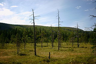
Ånderdalen National Park is located on the large island of Senja in Troms county, Norway. The 134-square-kilometre (52 sq mi) park lies within Senja Municipality. The park was established by royal decree on 6 February 1970 and it was enlarged in 2004. The national park preserves this Northern Norwegian coastal landscape. The bedrock consists of hard granite rocks and the landscape image gives exciting impressions of the glacial forces that have worked on Senja. The coastal pine forest in Ånderdalen has in some areas primeval forest with over 600 years old trees and countless marble pines and lower. Along the river there are many lush hawked birch forests and floodplain forests.

Øvre Dividal National Park is a national park in Målselv Municipality in Troms county, Norway. The park was opened in 1971 and has an area of 750 square kilometres (290 sq mi). The original intention was to preserve a very little disturbed inland valley and mountain area. The hiking trail Nordkalottruta passes through the national park.

Junkerdal National Park is a national park in the municipalities of Saltdal and Fauske in Nordland county, Norway, along its border with Sweden. The 682-square-kilometre (263 sq mi) park opened in 2004. It borders the Junkerdalsura nature reserve.
Anárjohka National Park is a national park that lies in Karasjok and Kautokeino municipalities in Finnmark county, Norway. The park was opened in 1976 and is 1,409 square kilometres (544 sq mi) in area. It borders on Lemmenjoki National Park in Finland. A process to expand the national park by an additional 624.6 km2 (241 sq mi) was started in 2009, however it was cancelled in 2015 after local opposition. Anárjohka national park is located on the interior of the Finnmarksvidda plateau and it includes extensive birch woods, pine barrens, bogs, and lakes.

Hardangervidda National Park, at 3,422 square kilometres (1,321 sq mi), is Norway's largest national park. It spans from Numedal and Uvdal in the east and Røvelseggi and Ullensvang in the west across the Hardanger mountain plateau (Hardangervidda). Designated as a national park in 1981, today it serves as a popular tourist destination for activities such as hiking, climbing, fishing, and cross-country skiing. The Norwegian Mountain Touring Association (DNT) maintains a comprehensive network of huts and paths across Hardangervidda. The Bergen Line and the main Highway 7 cross the plateau. The park lies in Buskerud, Vestland, and Telemark counties.
Nordenskiöld Land National Park is a national park in Spitsbergen island in the Svalbard archipelago, Norway.

The Scandinavian montane birch forests and grasslands is defined by the World Wildlife Fund (WWF) as a terrestrial tundra ecoregion in Norway, Sweden, and Finland.

Reinheimen National Park is a national park in Norway that was established in 2006. The park consists of a 1,969-square-kilometre (760 sq mi) continuous protected mountain area. It is located in Møre og Romsdal and Innlandet counties in Norway. The park includes parts of the municipalities of Lesja, Skjåk, Vågå, Lom, Fjord, and Rauma. The park consists of much of the Tafjordfjella mountain range as well as the reindeer habitat in the northern part of the Ottadalen valley.

Rohkunborri National Park is a national park in Troms county, Norway, that was established in 2011. The park consists of a 571-square-kilometre (220 sq mi) protected area, and is located in Bardu Municipality along the border with Sweden, about 30 kilometres (19 mi) southeast of the village of Setermoen and about 50 kilometres (31 mi) northeast of the town of Narvik.

Reisaelva or Reisa River is a river in Northern Norway, located in the county of Troms. It runs from the lake Reisavannet in the municipality of Nordreisa through the Reisa Valley and empties into the Reisafjorden in the municipality of Kåfjord.
Reisadalen or Reisa Valley is a valley in northern Norway stretching over 100 kilometres (62 mi) from the Finnish border to the Balsfjorden. Mountains, birch and pine forests, and rivers surround the valley. About 1700 people live in the valley.
Junkerdalen is a valley in Saltdal municipality in Nordland county. It is a side valley to Saltdalen and begins at Storfjord, from where it stretches in a south-easterly direction towards Graddis and the national border with Sweden. The beginning of Junkerdalen is a narrow gorge called Junkerdalsura, where Junkerdalselva flows into waterfalls and rapids before it joins with Lønselva and after this, it is called Saltdalselva. The side valleys Tjårrisdalen and Skaitidalen go out from Junkerdalen in a northerly direction. Up in the valley, Graddiselva and Skaitielva flow together, and from here the river is called Junkerdalselva. Between Tjårrisdalen and Junkerdalsura lies the village of Junkerdal.


