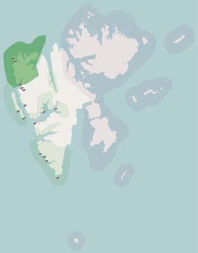
Svalbard, previously known as Spitsbergen or Spitzbergen, is a Norwegian archipelago in the Arctic Ocean. North of mainland Europe, it lies about midway between the northern coast of Norway and the North Pole. The islands of the group range from 74° to 81° north latitude, and from 10° to 35° east longitude. The largest island is Spitsbergen, followed in size by Nordaustlandet and Edgeøya. The largest settlement is Longyearbyen on the west coast of Spitsbergen.
Svalbard is an archipelago in the Arctic Ocean roughly centered on 78° north latitude and 20° east longitude. It constitutes the northernmost territory of the Kingdom of Norway. The three main islands in the group consist of Spitsbergen, Nordaustlandet and Edgeøya. There are also a number of smaller islands, such as Barents Island (Barentsøya), Kvitøya, Prins Karls Forland, Kongsøya, Bear Island, Svenskøya, Wilhelm Island and other smaller islands or skerries.

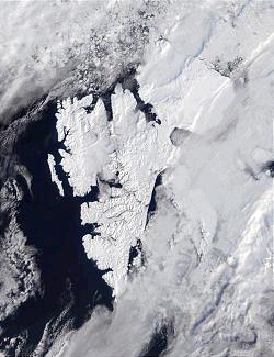
Spitsbergen, is the largest and the only permanently populated island of the Svalbard archipelago in northern Norway.

Bear Island is the southernmost island of the Norwegian Svalbard archipelago. The island is located at the limits of the Norwegian and Barents seas, approximately halfway between Spitsbergen and the North Cape. Bear Island was discovered by Dutch explorers Willem Barentsz and Jacob van Heemskerck on 10 June 1596. It was named after a polar bear that was seen swimming nearby. The island was considered terra nullius until the Spitsbergen Treaty of 1920 placed it under Norwegian sovereignty.

The Norwegian Polar Institute is Norway's central governmental institution for scientific research, mapping and environmental monitoring in the Arctic and the Antarctic. The NPI is a directorate under Norway's Ministry of Climate and Environment. The institute advises Norwegian authorities on matters concerning polar environmental management and is the official environmental management body for Norwegian activities in Antarctica.

Edgeøya, anglicised as Edge Island, is a Norwegian island located in southeast of the Svalbard archipelago; with an area of 5,073 square kilometres (1,960 sq mi), it is the third-largest island in this archipelago. An Arctic island, it forms part of the Søraust-Svalbard Nature Reserve, home to polar bears and reindeer. An ice field covers its eastern side. The island takes its name from Thomas Edge, an English merchant and whaler. It is seldom visited today and development of tourist facilities is forbidden by law because of its nature reserve status.

Danes Island is an island in Norway's Svalbard archipelago in the Arctic Ocean with an area of 40.6 km2 (15.7 sq mi). It lies just off the northwest coast of Spitsbergen, the largest island in the archipelago, near to Magdalenefjorden. Just to the north lies Amsterdam Island. Most of Svalbard's islands, including Danes Island, are uninhabited; only Spitsbergen, Bjørnøya and Hopen have settlements.
Nordenskiöld Land National Park is a national park in Spitsbergen island in the Svalbard archipelago, Norway.
Sør-Spitsbergen National Park encompasses the southern end of Spitsbergen island in the Svalbard archipelago, Norway. The park was opened in 1973 and includes Wedel Jarlsberg Land, Torell Land and Sørkapp Land. Over 65% of the region is ice cap, with much of the rest tundra.

Svalbard is a Norwegian archipelago in the Arctic Ocean. The climate of Svalbard is principally a result of its latitude, which is between 74° and 81° north. Climate is defined by the World Meteorological Organization as the average weather over a 30-year period. The North Atlantic Current moderates Svalbard's temperatures, particularly during winter, giving it up to 20 °C (36 °F) higher winter temperature than similar latitudes in continental Russia and Canada. This keeps the surrounding waters open and navigable most of the year. The interior fjord areas and valleys, sheltered by the mountains, have fewer temperature differences than the coast, with about 2 °C lower summer temperatures and 3 °C higher winter temperatures. On the south of the largest island, Spitsbergen, the temperature is slightly higher than further north and west. During winter, the temperature difference between south and north is typically 5 °C, and about 3 °C in summer. Bear Island (Bjørnøya) has average temperatures even higher than the rest of the archipelago.

The West Spitsbergen Current (WSC) is a warm, salty current that runs poleward just west of Spitsbergen,, in the Arctic Ocean. The WSC branches off the Norwegian Atlantic Current in the Norwegian Sea. The WSC is of importance because it drives warm and salty Atlantic Water into the interior Arctic. The warm and salty WSC flows north through the eastern side of Fram Strait, while the East Greenland Current (EGC) flows south through the western side of Fram Strait. The EGC is characterized by being very cold and low in salinity, but above all else it is a major exporter of Arctic sea ice. Thus, the EGC combined with the warm WSC makes the Fram Strait the northernmost ocean area having ice-free conditions throughout the year in all of the global ocean.

Indre Wijdefjorden National Park is located in a steep fjord landscape in northern Spitsbergen in Svalbard, Norway. It covers the inner part of Wijdefjorden—the longest fjord on Svalbard. The national park was established on 9 September 2005 and covers 1,127 km2 (435 sq mi), of which 745 km2 (288 sq mi) is on land and 382 km2 (147 sq mi) is sea. The marine environment changes vastly from the mouth of the fjord, through a still, cold, water basin, becoming deeper before reaching the glacier Mittag-Lefflerbreen at the inner-most sections of the fjord.

Nordaust-Svalbard Nature Reserve is located in the north-eastern part of the Svalbard archipelago in Norway. The nature reserve covers all of Nordaustlandet, Kong Karls Land, Kvitøya, Sjuøyane, Storøya, Lågøya, Wilhelm Island, Wahlbergøya and a small section of the north-east corner of Spitsbergen. The reserve is 55,354 square kilometres (21,372 sq mi), of which 18,663 square kilometres (7,206 sq mi) is on land and 36,691 square kilometres (14,166 sq mi) is on water—making it the largest preserved area in Norway. It includes the largest glacier in Norway, Austfonna, as well as Vestfonna and parts of Olav V Land. The reserve has been protected since 1 July 1973 and borders in the south to Søraust-Svalbard Nature Reserve.

Søraust-Svalbard Nature Reserve is located in the south-eastern part of the Svalbard archipelago in Norway. The nature reserve covers all of Edgeøya and Barentsøya in addition to a number of smaller islands, including Thousand Islands, Ryke Yseøyane and Halvmåneøya. The reserve is 21,825 square kilometres (8,427 sq mi), of which 6,400 square kilometres (2,500 sq mi) is on land and 15,426 square kilometres (5,956 sq mi) is on water—making it the second-largest preserved area in Norway. The reserve has been protected since 1 July 1973 and borders the Nordaust-Svalbard Nature Reserve to the north.
Svalbard is an Arctic, wilderness archipelago comprising the northernmost part of Norway. It is mostly uninhabited, with only about 3,000 people, yet covers an area of 61,020 square kilometres (23,560 sq mi).

Sverrefjellet is a mountain in Haakon VII Land at Spitsbergen, Svalbard, at the western side of Bockfjorden. It has a height of 507 m.a.s.l., and is an extinct volcano. Sverrefjellet is named after Sverre Sigurdsson.

The Arctic desert ecoregion is a terrestrial ecoregion that covers the island groups of Svalbard, Franz Josef Land, Severny Island and Severnaya Zemlya in the Arctic Ocean, above 75 degrees north latitude. The region is covered with glaciers, snow, and bare rock in a harshly cold environment. The temperature does rise above freezing for short periods in the summer, so some ice melt occurs, and the area supports colonies of sea birds and mammals. It has an area of 161,400 square kilometres (62,300 sq mi).

The wildlife of Norway includes the diverse flora and fauna of Norway. The habitats include high mountains, tundras, rivers, lakes, wetlands, sea coast and some lower cultivated land in the south. Mainland Norway has a long coastline, protected by skerries and much dissected by fjords, and the mostly-icebound archipelago of Svalbard lies further north. The flora is very varied and a large range of mammals, birds, fish and invertebrate species live here, as well as a few species of reptiles and amphibians.

Bjørlykkebreen is a glacier in Albert I Land, Spitsbergen, Svalbard. It is a tributary of Lillehöökbreen, and is debouching into the Lilliehöökfjorden. The glacier is named after Norwegian geologist Knut Olai Bjørlykke following a proposal in 1912 by Adolf Hoel who had traversed the glacier in 1909 together with Olaf Holtedahl.