
Rondane National Park is the oldest national park in Norway, established on 21 December 1962. The park is located in Innlandet county, in the municipalities of Dovre, Folldal, Sel, Nord-Fron, Sør-Fron, Stor-Elvdal, and Ringebu. The park contains ten peaks above 2,000 metres (6,560 ft), with the highest being Rondeslottet at an altitude of 2,178 m (7,146 ft). The park is an important habitat for herds of wild reindeer.

Dovre National Park is a national park in Innlandet county, Norway. The park was established in 2003. The park covers an area of 289 square kilometres (112 sq mi) and the altitude varies from the tree line at about 1,000 metres (3,300 ft) up to its highest point at Fokstuhøe at 1,716 metres (5,630 ft). The area consists of plateaus and weathered, rounded mountain peaks.

Dovrefjell–Sunndalsfjella National Park is a National Park in Norway. It was established in 2002 to replace and enlarge the former Dovrefjell National Park which had been established in 1974. The park occupies 1,693 square kilometres (654 sq mi) and encompasses areas in three Norwegian counties: Innlandet, Trøndelag, and Møre og Romsdal and includes large parts of the mountain range of Dovrefjell along with the Sunndalsfjella mountains. Together with the National Park, there are eight landscape protected areas and two biotope protected areas that were established adjacent to the park in 2002, comprising a total protected area of 4,366 square kilometres (1,686 sq mi). The park itself lies within the municipalities of Dovre and Lesja, Oppdal municipality, and Sunndal and Molde municipalities.
Hardangervidda is a mountain plateau in central southern Norway, covering parts of Vestland, Telemark, and Buskerud counties. It is the largest plateau of its kind in Europe, with a cold year-round alpine climate, and one of Norway's largest glaciers, Hardangerjøkulen, is situated here. Much of the plateau is protected as part of Hardangervidda National Park. Hardangervidda is a popular tourist and leisure destination, and it is ideal for many outdoor activities.

Børgefjell National Park is an undeveloped national park in Norway, straddling the border between Trøndelag and Nordland counties, along the border with Sweden. The park is undeveloped with few trails or other facilities for visitors. Visitors can hike for extended periods without seeing another person. The 1,447-square-kilometre (559 sq mi) park was originally established in 1963, and it was enlarged in 1973 and 2003. It now includes land in the municipalities of Hattfjelldal, Grane, Namsskogan, and Røyrvik.

Femundsmarka National Park is a national park in Innlandet and Trøndelag counties in Norway. The landscape is largely marshes and lakes. It is a popular destination for canoeing and fishing. The park was formed in 1971 to protect the lake and the forests stretching eastwards to Sweden. Indeed, the landscapes here are more Swedish in appearance than recognisably Norwegian. The forest is sparse and consists of craggy pine and birch.

Blåfjella–Skjækerfjella National Park lies in Trøndelag county, Norway. It is the third largest national park on the Norwegian mainland and one of the largest remaining true wilderness areas. It is located in the municipalities of Verdal, Snåsa, Grong, Lierne, and Steinkjer. The terrain is characterized by mountain plains, lakes, forested valleys, marshes, and a few mountain peaks. The Sami people have lived in and used the area for several centuries. There are many Sami cultural monuments here, such as settlements, gathering places, burial sites, and sacred places.
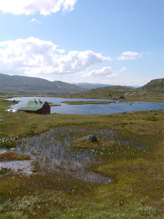
Forollhogna National Park is a national park in the counties of Trøndelag and Innlandet in Norway. Forollhogna park includes extensive plant life and is an important range for wild reindeer. The park lies in the municipalities of Tynset, Tolga, and Os in Innlandet and Holtålen, Midtre Gauldal, and Rennebu in Trøndelag.

Jotunheimen National Park is a national park in Norway, recognized as one of the country's premier hiking and fishing regions. The national park covers 1,151 square kilometres (444 sq mi) and is part of the larger area Jotunheimen. More than 250 peaks rise above an elevation of 1,900 metres (6,200 ft), including Northern Europe's three highest peaks: Galdhøpiggen at 2,469 metres (8,100 ft), Glittertind at 2,452 metres (8,045 ft) and Store Skagastølstind at 2,405 metres (7,890 ft).
Filefjell is a mountainous area in Norway. It is located between Lærdal in the Vestland county and Valdres in Innlandet county. It is the historical, as well as modern, main route, linking Western Norway and Eastern Norway. The European route E16 highway passes through Filefjell.
Stabbursdalen National Park is a national park in North Norway. It contains the northernmost pine forest in the world. It is located in Porsanger Municipality in Finnmark county, Norway. The park surrounds the Stabburselva river and its surrounding valley, just west of the large Porsangerfjorden. A small corner of the park extends into neighboring Hammerfest Municipality.

Ånderdalen National Park is located on the large island of Senja in Troms county, Norway. The 134-square-kilometre (52 sq mi) park lies within Senja Municipality. The park was established by royal decree on 6 February 1970 and it was enlarged in 2004. The national park preserves this Northern Norwegian coastal landscape. The bedrock consists of hard granite rocks and the landscape image gives exciting impressions of the glacial forces that have worked on Senja. The coastal pine forest in Ånderdalen has in some areas primeval forest with over 600 years old trees and countless marble pines and lower. Along the river there are many lush hawked birch forests and floodplain forests.

Øvre Dividal National Park is a national park in Målselv Municipality in Troms county, Norway. The park was opened in 1971 and has an area of 750 square kilometres (290 sq mi). The original intention was to preserve a largely undisturbed inland valley and mountain area. The hiking trail Nordkalottruta passes through the national park.
Øvre Pasvik National Park is located in the southeastern part of the Pasvikdalen valley in southern Sør-Varanger Municipality in Finnmark county, Norway. Covering an area of 119 square kilometers (46 sq mi), the national park is dominated by Siberian-like taiga consisting of old-growth forests of Scots pine, shallow lakes and bog. Proposals for a national park in Øvre Pasvik were first launched in 1936, but the park was not created until 6 February 1970. It originally covered 66 square kilometers (25 sq mi), but was expanded on 29 August 2003. Øvre Pasvik is part of Pasvik–Inari Trilateral Park along with the adjacent Øvre Pasvik Landscape Protection Area, the joint Norwegian and Russian Pasvik Nature Reserve, and Finland's Vätsäri Wilderness Area.

Junkerdal National Park is a national park in Saltdal Municipality and Fauske Municipality in Nordland county, Norway, along its border with Sweden. The 682-square-kilometre (263 sq mi) park opened in 2004. It borders the Junkerdalsura nature reserve.

Hardangervidda National Park, at 3,422 square kilometres (1,321 sq mi), is Norway's largest national park. It spans from Numedal and Uvdal in the east and Røvelseggi and Ullensvang in the west across the Hardanger mountain plateau (Hardangervidda). Designated as a national park in 1981, today it serves as a popular tourist destination for activities such as hiking, climbing, fishing, and cross-country skiing. The Norwegian Mountain Touring Association (DNT) maintains a comprehensive network of huts and paths across Hardangervidda. The Bergen Line and the main Highway 7 cross the plateau. The park lies in Buskerud, Vestland, and Telemark counties.

Reinheimen National Park is a national park in Norway that was established in 2006. The park consists of a 1,969-square-kilometre (760 sq mi) continuous protected mountain area. It is located in Møre og Romsdal and Innlandet counties in Norway. The park includes parts of the municipalities of Lesja, Skjåk, Vågå, Lom, Fjord, and Rauma. The park consists of much of the Tafjordfjella mountain range as well as the reindeer habitat in the northern part of the Ottadalen valley.

Rohkunborri National Park is a national park in Troms county, Norway, that was established in 2011. The park consists of a 571-square-kilometre (220 sq mi) protected area, and is located in Bardu Municipality along the border with Sweden, about 30 kilometres (19 mi) southeast of the village of Setermoen and about 50 kilometres (31 mi) northeast of the town of Narvik.
Lomsdal–Visten National Park is a Norwegian national park that was established on 26 June 2009. The park consists of a total protected area of 1,102 square kilometres (425 sq mi). It is located in Nordland county, Norway, and covers parts of Brønnøy Municipality, Vevelstad Municipality, Grane Municipality, and Vefsn Municipality.

Lofotodden National Park is a national park located in Moskenes Municipality and Flakstad Municipality in Nordland county, Norway. It is located not far from the Arctic Circle on the island of Moskenesøya in the Lofoten archipelago.


