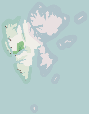
Svalbard, previously known as Spitsbergen or Spitzbergen, is a Norwegian archipelago in the Arctic Ocean. North of mainland Europe, it lies about midway between the northern coast of Norway and the North Pole. The islands of the group range from 74° to 81° north latitude, and from 10° to 35° east longitude. The largest island is Spitsbergen, followed in size by Nordaustlandet and Edgeøya. The largest settlement is Longyearbyen on the west coast of Spitsbergen.
Svalbard is an archipelago in the Arctic Ocean roughly centered on 78° north latitude and 20° east longitude. It constitutes the northernmost territory of the Kingdom of Norway. The three main islands in the group consist of Spitsbergen, Nordaustlandet and Edgeøya. There are also a number of smaller islands, such as Barents Island (Barentsøya), Kvitøya, Prins Karls Forland, Kongsøya, Bear Island, Svenskøya, Wilhelm Island and other smaller islands or skerries.

Norway is a country located in Northern Europe in the northern and western parts of the Scandinavian Peninsula. The majority of the country borders water, including the Skagerrak inlet to the south, the North Sea to the southwest, the North Atlantic Ocean to the west, and the Barents Sea to the north. It has a land border with Sweden to the east; to the northeast it has a shorter border with Finland and an even shorter border with Russia.

Isfjorden is the second longest fjord in the Norwegian archipelago of Svalbard. It lies on the west side of Spitsbergen, an island in the Arctic Ocean about midway between Norway and the North Pole, and the largest in the archipelago. The mountain of Alkhornet stands on the northern side of the entrance to the fjord, as does the coastal plain of Daudmannsøyra. A portion of Isfjorden is included in the national parks of Norway as Nordre Isfjorden Land National Park. Around the fjord lie many of the largest settlements in Svalbard: Barentsburg, Longyearbyen and Pyramiden.
Billefjorden is the central fjord of the three branching from the innermost part of the Isfjorden to the northeast, in Svalbard, Norway. It is 30 km long and 5–8 km wide. Billefjorden lies between Dickson Land to the northwest and Bünsow Land in the southeast. Located on its northwestern shore is the former Russian coal mining community of Pyramiden. To the northeast is Nordenskiöldbreen. At its northeastern extreme is Adolf Bay.
Adventfjorden is a 7 km long and 4 km wide bay running south-eastwards from the southern side of Isfjorden, on the west coast of Spitsbergen in Svalbard. The name represents a corruption of Adventure Bay - probably named after the Hull-built whaleship Adventure, which operated in Isfjorden in 1656. The fjord was originally known as Klass Billen Bay. At the head of Adventfjorden is Adventdalen.
Grønfjorden is a 16 km long fjord, separated from Isfjorden to the north by Festningsodden in the west and Heerodden in the east. It lies within the western portion of Nordenskiöld Land. On its eastern shore is the mining community of Barentsburg, the second largest settlement on Spitsbergen.
Ekmanfjorden is an 18 km (11 mi) long fjord branching north from inner Isfjorden. It is separated by Nordfjorden to the south by Sveaneset in the west and Kapp Wærn in the east. It lies within Nordre Isfjorden National Park.

Svalbard is a Norwegian archipelago in the Arctic Ocean. The climate of Svalbard is principally a result of its latitude, which is between 74° and 81° north. Climate is defined by the World Meteorological Organization as the average weather over a 30-year period. The North Atlantic Current moderates Svalbard's temperatures, particularly during winter, giving it up to 20 °C (36 °F) higher winter temperature than similar latitudes in continental Russia and Canada. This keeps the surrounding waters open and navigable most of the year. The interior fjord areas and valleys, sheltered by the mountains, have fewer temperature differences than the coast, with about 2 °C lower summer temperatures and 3 °C higher winter temperatures. On the south of the largest island, Spitsbergen, the temperature is slightly higher than further north and west. During winter, the temperature difference between south and north is typically 5 °C, and about 3 °C in summer. Bear Island (Bjørnøya) has average temperatures even higher than the rest of the archipelago.

Adventdalen is a 30-kilometre (19 mi) valley on the island Spitsbergen in Svalbard, Norway. The river that runs through the valley, Adventdalselva, flows into Adventfjorden just outside Longyearbyen. Adventfjorden is an arm of Isfjorden.

Indre Wijdefjorden National Park is located in a steep fjord landscape in northern Spitsbergen in Svalbard, Norway. It covers the inner part of Wijdefjorden—the longest fjord on Svalbard. The national park was established on 9 September 2005 and covers 1,127 km2 (435 sq mi), of which 745 km2 (288 sq mi) is on land and 382 km2 (147 sq mi) is sea. The marine environment changes vastly from the mouth of the fjord, through a still, cold, water basin, becoming deeper before reaching the glacier Mittag-Lefflerbreen at the inner-most sections of the fjord.
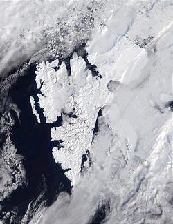
Svalbard is an Arctic, wilderness archipelago comprising the northernmost part of Norway. It is mostly uninhabited, with only about 3,000 people, yet covers an area of 61,020 square kilometres (23,560 sq mi).
Nordfjorden or Nordfjord may refer to:
Nordfjorden is a northern branch of the fjord Isfjorden at Spitsbergen, Svalbard. It is located between Bohemanneset and Kapp Thordsen, and branches further into the fjords Ekmanfjorden and Dicksonfjorden. The 30 kilometer long glacier Sveabreen debouches into the fjord.

Geologryggen is a mountain ridge in Oscar II Land at Spitsbergen, Svalbard. The ridge has a length of about four kilometers, and is located between Kjerulfbreen and Esmarkbreen. Geologryggen is included in the Nordre Isfjorden National Park.
Sefströmbreen is a glacier in James I Land at Spitsbergen, Svalbard. It is debouching into Ekmanfjorden at the northern side of Isfjorden. The glacier is named after Nils Gabriel Sefström. During a surge in 1896 the glacier deposited large moraine ridges in the inner part of the fjord, and these can be seen at the islands of Coraholmen and Flintholmen. Sefströmbreen is included in the Nordre Isfjorden National Park.
Coraholmen is an island in Ekmanfjorden in James I Land at Spitsbergen, Svalbard, at the northern side of Isfjorden. It has a length of 3.3 kilometers, and a width of 1.8 kilometers. The island is named after the fossil species Productus cora, which is common on the island. Part of the island is dominated by moraine ridges deposited by the glacier Sefströmbreen during a surge in 1896. Coraholmen is included in the Nordre Isfjorden National Park.

Flintholmen is a small island in Ekmanfjorden in James I Land at Spitsbergen, Svalbard, at the northern side of Isfjorden. Associated with the islet is a wide shoal area with depths between zero and three meters, with an extension of about one nautical mile. Part of Flintholmen and the nearby island of Coraholmen are dominated by moraine ridges deposited by the glacier Sefströmbreen during a surge in 1896. Ekmanfjorden and its islands are included in the Nordre Isfjorden National Park.

The Arctic desert ecoregion is a terrestrial ecoregion that covers the island groups of Svalbard, Franz Josef Land, Severny Island and Severnaya Zemlya in the Arctic Ocean, above 75 degrees north latitude. The region is covered with glaciers, snow, and bare rock in a harshly cold environment. The temperature does rise above freezing for short periods in the summer, so some ice melt occurs, and the area supports colonies of sea birds and mammals. It has an area of 161,400 square kilometres (62,300 sq mi).