
James I Land is a land area on the northwestern part of Spitsbergen, Svalbard. It is named after King James I of England and Scotland. [1] The 30 kilometer long glacier Sveabreen divides James I Land from Oscar II Land. [2]
James I Land is a land area on the northwestern part of Spitsbergen, Svalbard. It is named after King James I of England and Scotland. [1] The 30 kilometer long glacier Sveabreen divides James I Land from Oscar II Land. [2]

Oscar II Land is the land area between Isfjorden and Kongsfjorden on Spitsbergen, Svalbard. The 30 km (19 mi) long glacier Sveabreen divides Oscar II Land from James I Land.
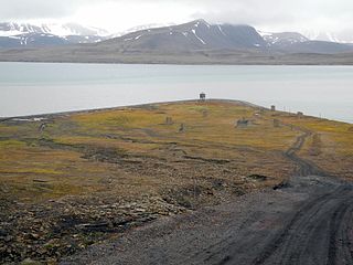
Finneset is a peninsula located on the east side of Grønfjorden on Spitsbergen in Svalbard, Norway. It is located 2 kilometers (1.2 mi) south of Barentsburg. A whaling station was located there until 1905. From 1911 it became the site of the first wireless station in the Arctic, named Svalbard Radio from 19 September 1925. It was also a meteorological station operated by the Norwegian Meteorological Institute. Both services moved to Longyearbyen on 1 September 1930. It is named for being a fine place to land a ship.
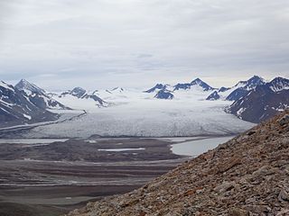
St. Jonsfjorden is a fjord in Oscar II Land at Spitsbergen, Svalbard. It has a length of 21 kilometer, and opens westwards into the strait of Forlandsundet. Several glaciers debouche into the fjord, including Gaffelbreen and Konowbreen from the north, a merge of Osbornebreen, Devikbreen, Vintervegen, Paulbreen and Bukkebreen at the bottom, and Vegardbreen, Charlesbreen and Bullbreen from the south.
Osbornebreen is a glacier in Oscar II Land at Spitsbergen, Svalbard, Norway. It has a length of 21 kilometers, merges with the glaciers Devikbreen, Klampebreen and Vintervegen, and debouches into St. Jonsfjorden. The mountain ridge Goldschmidtfjella forms a six kilometer long nunatak in the glacier.
Vintervegen is a glacier in Oscar II Land at Spitsbergen, Svalbard. It has a length of about 7.5 kilometers (4.7 mi). The glacier borders to the mountain of Klampen, merges with Osbornebreen and other glaciers, and the merged glacier stream debouches into the head of St. Jonsfjorden.
Nordfjorden is a northern branch of the fjord Isfjorden at Spitsbergen, Svalbard. It is located between Bohemanneset and Kapp Thordsen, and branches further into the fjords Ekmanfjorden and Dicksonfjorden. The 30 kilometer long glacier Sveabreen debouches into the fjord.

Sveabreen is a glacier between Oscar II Land and James I Land at Spitsbergen, Svalbard. It has a length of 30 kilometers (19 mi), stretching from Kongsvegpasset at an altitude about 750 meters (2,460 ft), and debouching into Nordfjorden.
Kongsvegpasset is a glaciated mountain pass at Spitsbergen, Svalbard, between Oscar II Land, Haakon VII Land and James I Land. It divides the three glaciers Sveabreen, Osbornebreen and Kongsvegen, at an altitude of about 750 meter. An aircraft beacon is installed at the site. Nearby mountains are the nunataks Vegvaktaren, Gjerstadfjellet and Centralen. North of the pass is the mountain Kongsvegsåta.
Jämtlandryggen is a mountain ridge in Oscar II Land at Spitsbergen, Svalbard. It has a length of 26 kilometer, and comprises a number of mountains with altitudes in the range roughly between 750 and 950 meters, including Årefjellet, Svenskane, Bydalsfjellet, Frösöfjellet, Ragundafjellet, Triryggtoppen and Gavltinden (Mediumfjellet). The ridge is located between the glaciers Sveabreen and Wahlenbergbreen.
Mediumfjellet is a mountain northwest of Yoldiabukta in Oscar II Land at Spitsbergen, Svalbard. It constitutes the southern part of the ridge Jämtlandryggen, and has several peaks and a length of 8 kilometers (5.0 mi). The highest peak is Gavltinden to the north. The mountain is located between the glaciers Sveabreen and Wahlenbergbreen.
Årefjellet is a mountain in Oscar II Land on the island of Spitsbergen, Svalbard. It has a maximum elevation of 882 m, and is located at the northern part of the ridge Jämtlandryggen. It borders to the glaciers Sveabreen and Wahlenbergbreen.
Muslingodden is a headland in Svalbard, Norway.
Rivalensundet is a strait in the Svalbard archipelago, separating Kongsøya from Svenskøya both in Kong Karls Land. It has a width of about 14 nautical miles. According to historical records, the strait was discovered in 1859, and first sailed in 1889. It is named after the vessel Rivalen.
Sefströmbreen is a glacier in James I Land at Spitsbergen, Svalbard. It is debouching into Ekmanfjorden at the northern side of Isfjorden. The glacier is named after Nils Gabriel Sefström. During a surge in 1896 the glacier deposited large moraine ridges in the inner part of the fjord, and these can be seen at the islands of Coraholmen and Flintholmen. Sefströmbreen is included in the Nordre Isfjorden National Park.
Coraholmen is an island in Ekmanfjorden in James I Land at Spitsbergen, Svalbard, at the northern side of Isfjorden. It has a length of 3.3 kilometers, and a width of 1.8 kilometers. The island is named after the fossil species Productus cora, which is common on the island. Part of the island is dominated by moraine ridges deposited by the glacier Sefströmbreen during a surge in 1896. Coraholmen is included in the Nordre Isfjorden National Park.

Flintholmen is a small island in Ekmanfjorden in James I Land at Spitsbergen, Svalbard, at the northern side of Isfjorden. Associated with the islet is a wide shoal area with depths between zero and three meters, with an extension of about one nautical mile. Part of Flintholmen and the nearby island of Coraholmen are dominated by moraine ridges deposited by the glacier Sefströmbreen during a surge in 1896. Ekmanfjorden and its islands are included in the Nordre Isfjorden National Park.
Comfortlessbreen is a glacier in Oscar II Land at Spitsbergen, Svalbard. It has a length of about fourteen kilometers, and a maximum width of three kilometers. The glacier debouches into Engelskbukta, after a merge with Uvêrsbreen. Comfortlessbreen is separated from Uvêrsbreen by the mountain range of Trondheimfjella.
Petuniabukta is a bay in Dickson Land at Spitsbergen, Svalbard. It constitutes the northern branch of Billefjorden. The bay is named after the Scottish vessel SS Petunia. Northwest of the bay is the valley of Hørbyedalen and the glacier of Hørbyebreen.
Trollheimen is a mountainous area in Oscar II Land at Spitsbergen, Svalbard, around the glacier of Eidembreen. Among the mountains of Trollheimen are Tussekallen, Runebomma, Heksefjellet, Huldrefjellet, Huldrehatten, Tomtegubben, and parts of Gunnar Knudsenfjella. North of Eidembreen is the glacier of Huldrebreen, and to the south are Heksebreen and Stallobreen.

Hayesbreen is a glacier in Sabine Land at Spitsbergen, Svalbard. It is named after American politician and Arctic explorer Isaac Israel Hayes. The glacier has a length of about eighteen kilometers, and debouches into the bay of Mohnbukta. Surrounding mountains are Aagaardfjellet to the north, Jebensfjellet to the south, and Panofskyfjellet where Hayesbreen joins the glacier of Königsbergbreen.
78°50′36″N14°18′06″E / 78.84333°N 14.30167°E
| | This Spitsbergen location article is a stub. You can help Wikipedia by expanding it. |