
West Alexander is a census-designated place in Donegal Township, Washington County, Pennsylvania, and formerly a borough in Washington County. Located less than a mile east of the border with West Virginia, the population was 604 at the 2010 census, just short of double the population of 320 recorded in the 2000 Census. The borough was dissolved into surrounding Donegal Township, effective January 1, 2009.

Lindale is a city in Smith County, Texas, United States. Located in East Texas, the population is currently around 6,711 in the 2023 census. It is part of the Tyler, Texas, metropolitan statistical area.

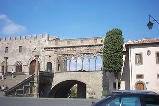
The province of Rieti is a province in the Lazio region of Italy. Its capital is the city of Rieti. Established in 1927, it has an area of 2,750.52 square kilometres (1,061.98 sq mi) with a total population of 157,887 people as of 2017. There are 73 comuni in the province.
The province of Viterbo is a province in the Lazio region of Italy. Its capital is the city of Viterbo.

Orvin is a municipality in the Jura bernois administrative district in the canton of Bern in Switzerland. It is located in the French-speaking Bernese Jura. Above it, there is a small year round resort, called les "Prés-d'Orvin".

Lakhta-Olgino Municipal Okrug is a municipal okrug of Primorsky District of the federal city of St. Petersburg, Russia, comprising that city's historical areas of Lakhta and Olgino. It is located just north of the Gulf of Finland. Population: 3,903 (2010 Census); 2,901 (2002 Census).

Salamina is a town and municipality in the Colombian department of Caldas. It is located north of the department and has a township called San Felix. It was declared a national monument and historic heritage of mankind.

Olav V Land is a peninsula in eastern Spitsbergen Island, Svalbard named after Olav V of Norway. It is covered by the Olav V Icefield, measuring about 4,150 square kilometres (1,600 sq mi).
Baranów is a village in the administrative district of Gmina Busko-Zdrój, within Busko County, Świętokrzyskie Voivodeship, in south-central Poland. It lies approximately 9 kilometres (6 mi) south-east of Busko-Zdrój and 55 km (34 mi) south of the regional capital Kielce.
Kików is a village in the administrative district of Gmina Solec-Zdrój, within Busko County, Świętokrzyskie Voivodeship, in south-central Poland. It lies approximately 5 kilometres (3 mi) north of Solec-Zdrój, 13 km (8 mi) south-east of Busko-Zdrój, and 56 km (35 mi) south of the regional capital Kielce.

Xigu District is one of 5 districts of the prefecture-level city of Lanzhou, the capital of Gansu Province, Northwest China. It is the westernmost part of the city of Lanzhou proper. Until 1952, Xigu was part of Gaolan County as a township and in 1953 it was established as the fifth district level division of Lanzhou. During this period, as part of China's first five-year plan, the petrochemical industry was developed in the area.

Vestfonna is an ice cap located on the western part Nordaustlandet in the Svalbard archipelago in Norway. The glacier covers an area of about 2,500 km2. It is the third largest ice cap in Svalbard and Norway by area, after Austfonna and Olav V Land.

Nordaust-Svalbard Nature Reserve is located in the north-eastern part of the Svalbard archipelago in Norway. The nature reserve covers all of Nordaustlandet, Kong Karls Land, Kvitøya, Sjuøyane, Storøya, Lågøya, Wilhelm Island, Wahlbergøya and a small section of the north-east corner of Spitsbergen. The reserve is 55,354 square kilometres (21,372 sq mi), of which 18,663 square kilometres (7,206 sq mi) is on land and 36,691 square kilometres (14,166 sq mi) is on water—making it the largest preserved area in Norway. It includes the largest glacier in Norway, Austfonna, as well as Vestfonna and parts of Olav V Land. The reserve has been protected since 1 July 1973 and borders in the south to Søraust-Svalbard Nature Reserve.
Mont Sutton is a ski area in the Eastern Townships located within the town of Sutton, Quebec, Canada, about 5 km directly east of its urban district.
Wedel Jarlsberg Land is the land area between Van Keulenfjorden and Hornsund on the southwestern part of Spitsbergen, Svalbard. The area is largely covered with glaciers, and is completely within the Sør-Spitsbergen National Park.
Prins Oscars Land is a land area constituting mainly Platenhalvøya, a peninsula between Rijpfjorden in the west and Duvefjorden with Fortherbyfjorden and Innvika on Nordaustlandet, Svalbard in Arctic Norway. Bordering Gustav V Land to the west, Gustav Adolf Land to the south, Orvin Land and Austfonna to the east. Limit over land through Rijpdalen and Flaumdalen in the west, to Winsnesbreen in the south, the lower part of Austfonna, through Fonndalen and Innvikdalen to the east.

Finn Malmgren Fjord is a fjord in Orvin Land at Nordaustlandet, Svalbard, between Glenhalvøya and Bergstrømodden. A land tongue of 0.5 kilometers separates the fjord from Adlersparrefjorden. Finn Malmgrenfjorden is named after Arctic explorer Finn Malmgren.
Bergströmodden is a headland in Orvin Land at Nordaustlandet, Svalbard. It is located north of the mountain Boydfjellet, at the mouth of Finn Malmgren Fjord, east of Alpini Island. The headland is named after Swedish politician Axel Bergström.
Palanderisen is a glaciated area in Gustav Adolf Land at Nordaustlandet, Svalbard. It has an extension of about 35 kilometers and is part of the ice cap of Austfonna, located west of the Sørdomen ice dome, between Etonbreen and Ericadalen. The area is named after Arctic explorer Louis Palander. It includes Sørfonna.
The Landstuhl Marsh or Landstuhl Bog is a region in West Palatinate in the German state of Rhineland-Palatinate.
