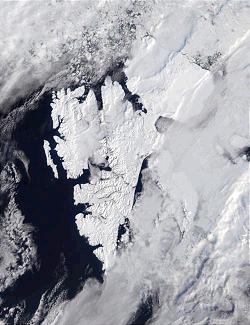
Svalbard is an archipelago in the Arctic Ocean roughly centered on 78° north latitude and 20° east longitude. It constitutes the northernmost territory of the Kingdom of Norway. The three main islands in the group consist of Spitsbergen, Nordaustlandet and Edgeøya. There are also a number of smaller islands, such as Barents Island (Barentsøya), Kvitøya, Prins Karls Forland, Kongsøya, Bear Island, Svenskøya, Wilhelm Island and other smaller islands or skerries.

Christian III reigned as King of Denmark from 1534 and King of Norway from 1537 until his death in 1559. During his reign, Christian formed close ties between the church and the crown. He established Lutheranism as the state religion within his realms as part of the Protestant Reformation, and was the first King of Denmark-Norway.
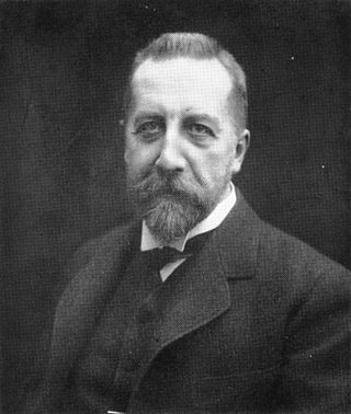
Peter Christian Hersleb Kjerschow Michelsen, better known as Christian Michelsen, was a Norwegian shipping magnate and statesman. He was the first prime minister of independent Norway and Norway's 9th prime minister from 1905 to 1907. Michelsen is most known for his central role in the dissolution of the union between Norway and Sweden in 1905, and was one of Norway's most influential politicians of his time.

Sverre Helge Hassel was a Norwegian polar explorer and one of the first five people to reach the South Pole.
Bjornesfjorden is a lake in the municipality of Nore og Uvdal in Buskerud county, Norway. It lies at 1,223 meters above sea level. It is drained by the Numedalslågen. Bjornesfjorden is situated in the Hardangervidda plateau and lies within the Hardangervidda National Park.
Events in the year 1954 in Norway.
Events in the year 1995 in Norway.
Events in the year 1872 in Norway.
Jonas Poole was an early 17th-century English explorer and sealer, and was significant in the history of whaling.
Events in the year 1920 in Norway.
Events in the year 1860 in Norway.

Amund Helland was a Norwegian geologist, politician and non-fiction writer. He is particularly known for his works on glacial erosion and the role of glaciers in the formation of valleys, fjords and lakes. He is also known for starting the series Norges Land og Folk, published in 20 volumes from 1885 to 1921.

Ytre Hvaler National Park is a national park located within the municipalities of Hvaler and Fredrikstad in Østfold, Norway. The park was established on 26 June 2009 and was the first national marine park in the country of Norway.

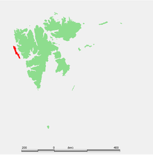
Karl XII-øya is an island north of the island of Nordaustlandet in Svalbard, Norway. Except for Sjuøyane, Karl XII-øya is the northernmost part of Svalbard, and thus also Norway.
Events in the year 1610 in Norway.

Poolepynten is a headland at the eastern coast of the Prins Karls Forland at Spitsbergen, Svalbard. It is located within the strait of Forlandsundet. The headland is named after British whaler Jonas Poole. It has a length of about 1.5 kilometers.
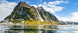
Monacofjellet is a mountain in Prins Karls Forland, Svalbard. It has a height of 1,084 m.a.s.l., and is the highest mountain of Forlandet. Monacofjellet is part of the Grampianfjella mountain ridge.

Færder National Park is a national park in Færder Municipality in Vestfold county, Norway. It is mostly a marine park, and includes some islands and coastal areas to the east of the larger islands of Nøtterøy and Tjøme. To the east, the national park borders to the Ytre Hvaler National Park. Færder covers an area of 340 km2 (130 sq mi), of which 325 km2 (125 sq mi) is sea and 15 km2 (6 sq mi) is land. The park was established on 23 August 2013. The park includes large parts of the archipelago of Bolærne, as well as the protected Færder Lighthouse and the ruins of Store Færder Lighthouse with its associated protected buildings.
Forlandsletta is a low-lying plain in the southern part of Prins Karls Forland in Svalbard, Norway. The plain is bounded by Bogtjørna, Methuenfjellet, Tjørnberget and Archibald Geikiebreen in the north to Vassdammen, the northernmost point on Persiskammen and further east to the coast. Forlandsletta is 19 km long, 5–7 km wide and up to 20 m above sea level.