Thousand Islands (Svalbard)

Last updated
Map of Thousand Islands NO-Tusenoyane.png
Map of Thousand Islands

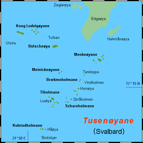
Thousand Islands [1] [2] [3] (Norwegian : Tusenøyane) is a group of small islands south of Edgeøya. They form part of the Svalbard archipelago. The group consists of over forty islands and islets, including Brotskjer, Kulstadholmane, Utsira, Tufsen, Kong Ludvigøyane, Bölscheøya, Hornøya, Tiholmane, Meinickeøyane, Sletteøya, Schareholmane, Skråholmen, Brækmoholmane, Tareloppa, Vindholmen, and Menkeøyane.

Norwegian language North Germanic language spoken in Norway

Norwegian is a North Germanic language spoken mainly in Norway, where it is the official language. Along with Swedish and Danish, Norwegian forms a dialect continuum of more or less mutually intelligible local and regional varieties, and some Norwegian and Swedish dialects, in particular, are very close. These Scandinavian languages, together with Faroese and Icelandic as well as some extinct languages, constitute the North Germanic languages. Faroese and Icelandic are hardly mutually intelligible with Norwegian in their spoken form because continental Scandinavian has diverged from them. While the two Germanic languages with the greatest numbers of speakers, English and German, have close similarities with Norwegian, neither is mutually intelligible with it. Norwegian is a descendant of Old Norse, the common language of the Germanic peoples living in Scandinavia during the Viking Era.

Edgeøya island

Edgeøya, occasionally anglicised as Edge Island, is a Norwegian island located in southeast of the Svalbard archipelago; with an area of 5,073 square kilometres (1,960 sq mi), it is the third largest island in this archipelago. An Arctic island, it forms part of the Søraust-Svalbard Nature Reserve, home to polar bears and reindeer. Its eastern side is covered by an ice field. The island is named after Thomas Edge, an English merchant and whaler. It is seldom visited today.

Svalbard Archipelago in the Arctic Ocean

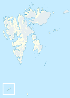
Svalbard is a Norwegian archipelago in the Arctic Ocean. Situated north of mainland Europe, it is about midway between continental Norway and the North Pole. The islands of the group range from 74° to 81° north latitude, and from 10° to 35° east longitude. The largest island is Spitsbergen, followed by Nordaustlandet and Edgeøya. Administratively, the archipelago is not part of any Norwegian county, but forms an unincorporated area administered by a governor appointed by the Norwegian government. Since 2002, Svalbard's main settlement, Longyearbyen, has had an elected local government, somewhat similar to mainland municipalities. Other settlements include the Russian mining community of Barentsburg, the research station of Ny-Ålesund, and the mining outpost of Sveagruva. Ny-Ålesund is the northernmost settlement in the world with a permanent civilian population. Other settlements are farther north, but are populated only by rotating groups of researchers.

Contents

History

The Dutchman Joris Carolus was the first to distinctly mark a group of small islands south of Edgeøya. The Muscovy Company's map (1625) showed a vague mass of islands as well, some labeled, such as Wester I., Beare Iland, Heling I., and the Hopeless Iles. (perhaps Kong Ludvigøyane). The cartographers Gerard Valck and Peter Schenk the Elder were the first to place a "great vague mass of islands stretching round the coast" south of Edgeøya. William Scoresby (1820) is thought to have been the first to label them with the popular name of Thousand Islands, the name they retain to this day.

Joris Carolus was a Dutch cartographer and explorer. He served for both the Noordsche Compagnie and the Vereenigde Oost-Indische Compagnie.

Muscovy Company 16th-century business enterprise

The Muscovy Company was an English trading company chartered in 1555. It was the first major chartered joint stock company, the precursor of the type of business that would soon flourish in England, and became closely associated with such famous names as Henry Hudson and William Baffin. The Muscovy Company had a monopoly on trade between England and Muscovy until 1698 and it survived as a trading company until the Russian Revolution of 1917. Since 1917 the company has operated as a charity, now working within Russia.

Gerard Valck was a Dutch engraver, publisher and cartographer.

Related Research Articles

Lågøya island in Svalbard

Lågøya is an island in Svalbard, Norway. It is situated north west of Nordaustlandet. The area is 103.5 km². The island has rarely been visited.

Storfjorden (Svalbard) fjord in Svalbard

Storfjorden is the body of water separating Spitsbergen in the west from Barentsøya and Edgeøya to the east. Its southern limits are Kikutodden in Sørkapp Land east to Håøya, Tiholmane, Brækmoholmane, and Menkeøyane in Thousand Islands and northeast to Negerpynten—the southeastern promontory of Edgeøya. Its limits on its eastern side are Sundneset on the northern side of Freemansundet south to Palibinramten on the northwest coast of Edgeøya. The northern part is called Ginevra Bay, which lies between Olav V Land and Barentsøya. It ends at Heleysundet.

Ryke Yseøyane is a group of several small islands off the east coast of the island of Edgeøya in Svalbard, Norway. The islands are named after the Dutch whaler Ryke Yse of Vlieland, who discovered them about 1640–1645. The group was first marked by Hendrick Doncker, of Amsterdam, in 1663. Two Norwegian polar bear hunters wintered on Ryke Yseøyane for two subsequent winters in 1967–1969. During the second winter, one of them was lost in drifting ice.

Halvmåneøya is a small, uninhabited Norwegian island off the southeastern coast of Edgeøya, part of the Svalbard archipelago. Halvmåneøya, as part of Edgeøya, has been a nature preserve since 1973, and visitation is strictly regulated.

Tjuvfjorden is a 45 km long and up to 30 km wide fjord separating Edgeøya’s two southern promontories, Kvalpynten and Negerpynten.

Menkeøyane island in Norway

Menkeøyane is a small Norwegian island group south of Halvmåneøya, an island off the southeast coast of Edgeøya. The group includes Havella, Alka, Gassen, Teisten, Islomen and Blåmåken. They comprise part of Thousand Islands. The islands are named after the German cartographer and historical geographer Heinrich Theodor Menke (1819–92). The islands appear on the Muscovy Company's map (1625), one of which is labeled Heling I.

Kong Ludvigøyane island in Norway

Kong Ludvigøyane is a small group of islands south of southwestern Edgeøya. The group includes Russebuholmane, Arendtsøya, Berentine Island, and Bruhnsøya. They form part of Thousand Islands. They are named after King Ludwig II (1845–86) of Bavaria, Germany. The islands may be the Hopeless Iles of the Muscovy Company's map (1625).

Meinickeøyane island in Norway

Meinickeøyane is an island group composed of two islets, Store Meinickeøya and Vesle Meinickeøya, that form part of Thousand Islands, an island group south of Edgeøya, part of the Svalbard archipelago. They were named after the German geographer Carl Eduard Meinicke (1803–76).

Brækmoholmane island group composed of three islands

Brækmoholmane is an island group composed of three islands, Store Brækmoholmen, Trønderen and Alkekongen. They form part of Thousand Islands, an archipelago south of Edgeøya. The islands are named after the Norwegian sailor and fisherman Sivert Brækmo (1853-1930), who visited Svalbard regularly between 1876 and 1895.

Tiholmane is a group of ten small islands that form part of Thousand Islands, an archipelago south of Edgeøya in Svalbard. The largest of the islands are Lurøya, Kalvøya, Langåra and Rugla. The group also includes the smaller Sperra, Spunset, Bommen, Proppen, Rullesteinøya and Røysholmen.

Lurøya is the largest island in Tiholmane, part of Thousand Islands, an island group south of Edgeøya.

Store Brækmoholmen is the largest island in Brækmoholmane, part of Thousand Islands, an island group south of Edgeøya. The island is named after Sivert Brækmo (1853-1930), a Norwegian sailor and fishermen who regularly visited Svalbard between 1876 and 1895.

Arendtsøya is a small island in Kong Ludvigøyane, part of Thousand Islands, an island group south of Edgeøya. The island is named after the German geographer Karl Arendts (1815–81).

Berentine Island

Berentine Island is the southernmost island in Kong Ludvigøyane, part of Thousand Islands, an island group south of Edgeøya in Svalbard, Norway.

Bruhnsøya is a small island in Kong Ludvigøyane, an island group in Thousand Islands, an archipelago south of Edgeøya. The island is named after the German astronomer Carl Christian Bruhns (1830–81).

Russebuholmane are the four westernmost islets in Kong Ludvigøyane, part of Thousand Islands, an archipelago south of Edgeøya. The largest is Ækongen. The other three comprise Russeholmane.

Russeholmane are the three outermost islets in Kong Ludvigøyane, part of Thousand Islands, an archipelago south of Edgeøya. Together with Ækongen they form Russebuholmane. They are named after a Russian trapper’s hut found on one of the islets.

Russeholmen is one of three islets that form part of Russeholmane, the westernmost group in Kong Ludvigøyane, part of Thousand Islands, an archipelago south of Edgeøya.

Søraust-Svalbard Nature Reserve

Søraust-Svalbard Nature Reserve is located in the south-eastern part of the Svalbard archipelago in Norway. The nature reserve covers all of Edgeøya and Barentsøya in addition to a number of smaller islands, including Thousand Islands, Ryke Yseøyane and Halvmåneøya. The reserve is 21,825 square kilometres (8,427 sq mi), of which 6,400 square kilometres (2,500 sq mi) is on land and 15,426 square kilometres (5,956 sq mi) is on water—making it the second-largest preserved area in Norway. The reserve has been protected since 1 July 1973 and borders in the north to Nordaust-Svalbard Nature Reserve.

References

  1. Vaughan, Richard. 1992. In Search of Arctic Birds. London: T & A D Poyser, p. 353.
  2. Reeves, Randall R. 1978. Atlantic Walrus (Odobenus rosmarus rosmarus): A Literature Survey and Status Report. Washington, DC: U.S. Dept. of the Interior, Fish and Wildlife Service, p. 9.
  3. Dodd, G. J., G. P. Benson, & D. T. Watts. 1996. Arctic Pilot, vol. 2. Taunton, UK: Hydrographer of the Navy, p. 225.
International Standard Book Number Unique numeric book identifier

The International Standard Book Number (ISBN) is a numeric commercial book identifier which is intended to be unique. Publishers purchase ISBNs from an affiliate of the International ISBN Agency.

Coordinates: 77°00′N21°30′E / 77.000°N 21.500°E / 77.000; 21.500

Geographic coordinate system Coordinate system

A geographic coordinate system is a coordinate system that enables every location on Earth to be specified by a set of numbers, letters or symbols. The coordinates are often chosen such that one of the numbers represents a vertical position and two or three of the numbers represent a horizontal position; alternatively, a geographic position may be expressed in a combined three-dimensional Cartesian vector. A common choice of coordinates is latitude, longitude and elevation. To specify a location on a plane requires a map projection.