The Arctic Archipelago, also known as the Canadian Arctic Archipelago, is a group of islands north of the Canadian mainland.
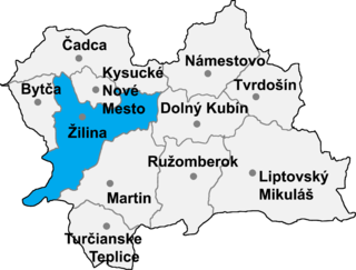
Veľká Čierna is a village and municipality in Žilina District in the Žilina Region of northern Slovakia.
Robleda-Cervantes is a municipality located in the province of Zamora, Castile and León, Spain. According to the 2004 census (INE), the municipality has a population of 476 inhabitants.

Piersno is a village in the administrative district of Gmina Kostomłoty, within Środa Śląska County, Lower Silesian Voivodeship, in south-western Poland. Prior to 1945 it was in Germany. It lies approximately 5 kilometres (3 mi) north-west of Kostomłoty, 8 km (5 mi) south of Środa Śląska, and 33 km (21 mi) west of the regional capital Wrocław.
Osina Wielka is a village in the administrative district of Gmina Ziębice, within Ząbkowice Śląskie County, Lower Silesian Voivodeship, in south-western Poland. Prior to 1945 it was in Germany.
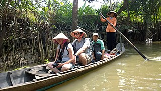
Cai Lậy is a Rural district of Tien Giang province in the Mekong Delta region of Vietnam. As of 2013 the district had a population of 186,583. The district covers an area of 296 km². The district capital lies at Bình Phú Commune. The town of Cai Lậy was separated from the district in 2013.
Balia, Bangladesh may refer to the following locations in Bangladesh:
Drogusza is a village in the administrative district of Gmina Bielawy, within Łowicz County, Łódź Voivodeship, in central Poland. It lies approximately 25 kilometres (16 mi) west of Łowicz and 35 km (22 mi) north of the regional capital Łódź.
The Findlay Group is a group of islands in the Canadian Arctic Archipelago in Qikiqtaaluk Region, Nunavut. This Arctic Ocean group consists of Lougheed Island, Stupart Island, Edmund Walker Island, Grosvenor Island and Patterson Island.
Pomocno is a village in the administrative district of Gmina Pakosław, within Rawicz County, Greater Poland Voivodeship, in west-central Poland. It lies approximately 16 kilometres (10 mi) east of Rawicz and 92 km (57 mi) south of the regional capital Poznań.
Olbrachtów is a village in the administrative district of Gmina Żary, within Żary County, Lubusz Voivodeship, in western Poland. It lies approximately 7 kilometres (4 mi) south-west of Żary and 50 km (31 mi) south-west of Zielona Góra.
Diankabou is a village and commune and seat of the Cercle of Koro in the Mopti Region of Mali. In 1998 the commune had a population of 14,760.
Ovchi is a town and jamoat in north-west Tajikistan. It is located in Ghonchi District in Sughd province. The jamoat has a total population of 23,407.
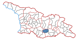
Tsalka is a district of Georgia, in the region of Kvemo Kartli. Its main town is Tsalka.
Chraštice is a village and municipality in Příbram District in the Central Bohemian Region of the Czech Republic.
Řeřichy is a village and municipality in Rakovník District in the Central Bohemian Region of the Czech Republic.

Thaba Chweu Local Municipality, is a municipality of South Africa, located in the Ehlanzeni District Municipality, Mpumalanga.
Umbusi is a village in Põltsamaa Parish, Jõgeva County in eastern Estonia.

Teshie-Nungua is a small town and is the capital of Ledzokuku-Krowor Municipal district, a district in the Greater Accra Region of Ghana.Teshie is a town on its own and different from Nungua. Nungua share boundaries with Sakumono, Lashibi and Team.